Coporaque District (Caylloma)
| Coporaque district | |
|---|---|
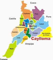
 The Coporaque district (marked purple) is centrally located in the Caylloma Province |
|
| Basic data | |
| Country | Peru |
| region | Arequipa |
| province | Caylloma |
| Seat | Coporaque |
| surface | 114 km² |
| Residents | 1089 (2017) |
| density | 9.6 inhabitants per km² |
| ISO 3166-2 | PE-ARE |
| politics | |
| Alcalde District | Fredy Terán Cacya (2019-2022) |
| Political party | Arequipa - Unidos por el Gran Cambio |
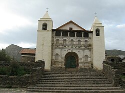
| Templo Santiago Apostol de Coporaque | |
Coordinates: 15 ° 38 ′ S , 71 ° 39 ′ W
The Coporaque district is located in the Caylloma Province in the Arequipa region in southwestern Peru . The district has an area of 114 km². The 2017 census counted 1089 inhabitants. In 1993 the population was 1232, in 2007 it was 1393. The district administration is located in the 3575 m high town of Coporaque with 760 inhabitants (as of 2017). Coporaque is just 5 km west-northwest of the provincial capital Chivay .
Geographical location
The Coporaque district is located in the Cordillera Volcánica on the north bank of the Río Colca flowing west . The maximum longitudinal extent in NNW-SSE direction is 16 km. In the far northwest of the district, the well-known volcano Nevado Mismi rises to a height of 5597 m .
The Coporaque district borders on the Ichupampa district in the west, the Lari district in the extreme northwest, the Tuti district in the north, the Chivay district in the southeast and the Yanque district in the south .
Individual evidence
- ↑ a b PERU: Arequipa region - provinces and districts . www.citypopulation.de. Retrieved May 8, 2020.
