Madrigal District
| Madrigal District | |
|---|---|
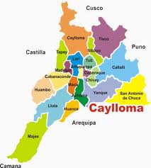
 The Madrigal District (marked purple) is located in the west of Caylloma Province |
|
| Basic data | |
| Country | Peru |
| region | Arequipa |
| province | Caylloma |
| Seat | madrigal |
| surface | 159 km² |
| Residents | 648 (2017) |
| density | 4.1 inhabitants per km² |
| ISO 3166-2 | PE-ARE |
| politics | |
| Alcalde District | Juan Yoni Tejada Castro (2019-2022) |
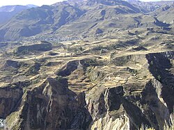
| Looking north over the Colca Gorge towards the Madrigal district | |
Coordinates: 15 ° 36 ′ S , 71 ° 48 ′ W
The Madrigal District is located in the Caylloma Province in the Arequipa region in southwestern Peru . The district has an area of 159 km². The 2017 census counted 648 residents. In 1993 the population was 1122, in 2007 it was 705. The district administration is located in the 3262 m high village of Madrigal with 641 inhabitants (as of 2017). Madrigal is 22 km west-northwest of the provincial capital Chivay .
Geographical location
The Madrigal district is located in the Cordillera Volcánica on the north bank of the west-flowing Río Colca . The lengthwise extension in north-south direction is about 15 km, the width is about 13 km. The 5432 m high Sepregina lies on the western border of the district.
The Madrigal district is bordered to the west by the district Tapay , to the east by the district Lari and the south by the district of Cabanaconde .
Individual evidence
- ↑ a b PERU: Arequipa region - provinces and districts . www.citypopulation.de. Retrieved May 8, 2020.
