Sibayo district
| Sibayo district | |
|---|---|
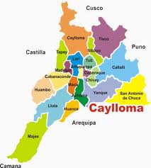
 The Sibayo District (marked in light green) is located in the northeast of the Caylloma Province |
|
| Basic data | |
| Country | Peru |
| region | Arequipa |
| province | Caylloma |
| Seat | Sibayo |
| surface | 284 km² |
| Residents | 669 (2017) |
| density | 2.4 inhabitants per km² |
| founding | January 25, 1943 |
| ISO 3166-2 | PE-ARE |
| politics | |
| Alcalde District | Isaac Samuel Noa Supo (2019-2022) |
| Across the Río Colca is Sibayo (top left in the picture) | |
Coordinates: 15 ° 29 ′ S , 71 ° 27 ′ W
The Sibayo District is located in the Caylloma Province in the Arequipa region in southwestern Peru . The district was established on January 25, 1943. It has an area of 284 km². The 2017 census counted 669 inhabitants. In 1993 the population was 919, in 2007 801. The district administration is located in the 3810 m high town of Sibayo (also San Juan Bautista de Sibayo) with 539 inhabitants (as of 2017). Sibayo is located 23 km northeast of the provincial capital Chivay .
Geographical location
The Sibayo District is located in the Cordillera Volcánica in the northeast of the Caylloma Province. The maximum length in north-south direction is 40 km. The Río Colca flows through the south of the district in a predominantly southwestern direction. Along the northwestern district boundary, the Río Hornillos flows north to the Río Apurímac .
The Sibayo district borders in the southwest on the Tuti district , in the northwest on the Caylloma district , in the east on the Tisco district , in the southeast on the Callalli district and in the extreme south on the Chivay district .
Individual evidence
- ↑ a b PERU: Arequipa region - provinces and districts . www.citypopulation.de. Retrieved May 8, 2020.
