Layo District
| Layo District | |
|---|---|
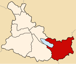
 Location of the district (marked in red) in the province of Canas |
|
| Basic data | |
| Country | Peru |
| region | Cusco |
| province | Canas |
| Seat | Layo |
| surface | 452.6 km² |
| Residents | 5171 (2017) |
| density | 11 inhabitants per km² |
| founding | January 2, 1857 |
| ISO 3166-2 | PE-CUS |
| Website | munilayo.gob.pe (Spanish) |
| politics | |
| Alcalde District | Aurelio Cáceres Huayta (2019-2022) |
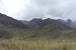
| Landscape in the northeast of the district | |
Coordinates: 14 ° 30 ′ S , 71 ° 9 ′ W
The Layo district is located in the Canas Province in the Cusco region in south-central Peru . The district was founded on January 2, 1857. It has an area of 452.56 km². The 2017 census counted 5171 inhabitants. In 1993 the population was 3399, in 2007 it was 2965. The district administration is located in Layo, at an altitude of 3978 m , with 671 inhabitants (as of 2017). Layo is located 45 km south-southeast of the provincial capital Yanaoca on the east bank of the Laguna Langui Layo lake .
Geographical location
The Layo district is located in the Andean highlands in the southeast of the Canas province. It includes the eastern part of the Lago Langui Layo lake and the associated catchment area . In the northeast of the district is the headwaters of the Río Vilcanota , the upper reaches of the Río Urubamba.
Layo district borders in the northwest on the Langui district , in the north on the Marangani district ( Canchis province ), in the east on the districts Santa Rosa and Macari (both in the province of Melgar ), in the southeast on the districts Alto Pichigua and Pichigua (both in the province of Espinar ) and in the west to the district of Kunturkanki .
Web links
- Municipalidad Distrital de Layo
- Peru: Region Cusco (provinces and districts) at www.citypopulation.de
- INEI Perú

