Dolle (Burgstall)
|
Oarlock
Burgstall municipality
|
||
|---|---|---|
| Coordinates: 52 ° 24 ′ 31 ″ N , 11 ° 37 ′ 31 ″ E | ||
| Height : | 69 m above sea level NHN | |
| Area : | 50.17 km² | |
| Residents : | 513 (Dec. 31, 2017) | |
| Population density : | 10 inhabitants / km² | |
| Incorporation : | January 1, 2010 | |
| Postal code : | 39517 | |
| Area code : | 039364 | |
|
Location in Saxony-Anhalt |
||
Dolle is a district of the municipality of Burgstall in the northeast of the Börde district in Saxony-Anhalt .
geography
The Dollgraben , one of the numerous Tangier spring brooks , rises near Dolle in the middle of the Colbitz-Letzlinger Heide . The extraordinarily wooded area north of Dolle rises to the northwest and reaches 130 m above sea level. NN . The village is located around 33 km north of the state capital Magdeburg . The district borders in the north on the district of Stendal and in the north-west on the Altmarkkreis Salzwedel .
history
The village was the ancestral seat of the noble family von der Dollen . The Heidedorf Dolle was until the dissolution of Prussia in 1947 in the province of Saxony of the Kingdom of Prussia and had a direct border with the Brunswick office of Calvörde .
On January 1, 2010 the previously independent municipalities of Dolle, Cröchern , Sandbeiendorf and Burgstall merged to form the new municipality of Burgstall.
The following were identified as living spaces in the municipality:
- Forestry settlement
- settlement
- Stone mountains
badges and flags
The coat of arms was approved on October 27, 1994 by the Magdeburg Regional Council.
Blazon : "In silver, a striding red stag on a tinned red wall in the base of the shield."
The church colors were red - silver (white).
The flag of the municipality of Dolle showed the colors red and white with the municipality's coat of arms.
Economy and Infrastructure
Dolle is a quiet heathland with tourist potential. In recent years, a wellness hotel and a senior citizens' residential complex have been built. The community is also known regionally for the motocross races that take place near Dolle .
The region immediately west of Dolle is still largely used by the Bundeswehr as a military training area. The military development began as early as 1934. From 1945 to 1994 the Colbitz-Letzlinger Heide - similar to the Lüneburg Heath by NATO - was used by the troops of the Soviet Army due to favorable military strategic conditions . Today, some citizens' initiatives advocate a tourist use of the Colbitz-Letzlinger Heide and thus for a withdrawal of the Bundeswehr.
Transport links
Dolle is on federal highway 189 , halfway between Magdeburg and Stendal . There are other road connections via Burgstall to Tangerhütte and Angern / Rogätz . The former road, which once led directly into the Altmark , has been blocked for decades by the large military training area in the Colbitz-Letzlinger Heide, so that the community of Letzlingen, 12 km away, could only be reached via the almost 50 km detour via Uchtspringe for a long time . A cross-connection from Colbitz (on the B 189) to Born (on the B 71 ) has been open to road traffic since 2004 , which shortens the detour to approx. 33 km. The next train stations are in Mahlwinkel and Tangerhütte on the Magdeburg – Wittenberge route . The Altmark motorway from Magdeburg to Schwerin (in the planning stage) will pass near Dolle.
Attractions
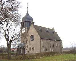
The Protestant village church in Dolle was built in 1907 in the local style.
In 1951 the memorial for the victims of the fascist terror was inaugurated at the northern entrance to the town.
Personalities
In Dolle, the pedagogue, writer and cultural politician Otto Bernhard Wendler worked briefly as a teacher around 1919/20 .


