
Dolomites high path 1
| Dolomites high path 1 Alta Via delle Dolomiti n.1 |
|
|---|---|
 Pragser Wildsee, starting point of the Dolomites High Trail 1 |
|
| Data | |
| length | 150 km |
| location | Italy |
| Markers |

|
| Starting point |
Pragser Wildsee 46 ° 41 ′ 51.8 ″ N , 12 ° 5 ′ 2.4 ″ E |
| Target point |
Belluno 46 ° 8 ′ 22.6 ″ N , 12 ° 13 ′ 1.2 ″ E |
| Type | Long-distance hiking trail |

The Dolomiten-Höhenweg 1 , called Alta Via delle Dolomiti n.1 in Italian , is a long-distance hiking trail in the Alps . As a classic route, it leads in 9 to 13 daily stages over a distance of 150 km from Lake Braies to Belluno .
Course and requirements
The Dolomiten-Höhenweg 1 runs along the main ridges of the eastern Dolomite groups towards the south. The route leads through the mountain groups of the Braies Dolomites , Fanes Group, Nuvolàu, Croda da Lago , Rochetta, Pelmo , Civetta , Moiazza , Prampèr-Dolomites and Schiara and moves at an altitude of between 1500 m and 2800 m through alpine terrain.
As the first to be laid out in the Dolomites high-altitude trail, Alta Via n.1 is also the easiest of them: Especially in the northern and central sections of the trail, so many huts offer accommodation and food that the distances between the huts and inns are relatively short. Depending on fitness and leisure, these sections can be combined into short stages of an average of 3.30-5.00 hours of walking or combined into longer day tours, but can generally also be mastered by hikers with normal fitness. This applies not only to the length of the sections, but also to their degree of difficulty and the orientation on the way. A blue triangle and the usual red and white signposts mark the well laid out and maintained route, which does not cross any glaciers and is well secured with wire ropes at the few exposed places. The paths, climbs and natural roads are generally easy to moderately difficult to walk and are therefore also suitable for those who are not experienced in the high mountains.
An exception, however, is the stage from Rifugio Pian de Fontana to Rifugio 7 ° Alpini (which can be bypassed if you don't trust yourself or if the weather forces you to avoid it). It leads over the Màrmol via ferrata , which is secured with wire ropes and ladders and requires surefootedness, a head for heights and climbing skills up to level II . Although this Via Ferrata is technically not particularly demanding, it requires a lot of endurance from the mountaineer due to its great length. In return, this stage is the crowning glory of the high path for experienced hikers and is an experience for the simple reason that when the visibility is good, the sea can be seen or at least smelled from the Schiara ridge in the profile.
Characteristic
Hiking guides and magazines praise the Alta via n. 1 as the most beautiful of the Dolomite high-altitude trails . From the smoothly polished and steeply sloping plates of the Seekofel to the salty breeze that blows in the Schiara ridge when the wind direction is right; From the quiet Federa mountain lake to the chamois colony in the Van de Zità de fòra - great impressions of the landscape and nature await on each of the stages. Ski lifts and slopes can only be seen from Passo Falzàrego to Rifugio Cinque Torri .
You can expect a lot of activity at easily accessible huts like the Faneshütte, at concentration points like the Pragser Wildsee and at passes like the Passo Falzàrego; Many of the sections of the trail are surprisingly lonely despite their low degree of difficulty on the one hand and their extraordinary scenic beauty on the other. Especially in the south, you will only meet a few hikers and mountaineers on the way, even in season.
The Dolomiten-Höhenweg 1 leads through three language areas and the cultures associated with them: Starting in the German-speaking Pustertal , it then runs through the Ladin Fanes area. The legends of the Ladins tell of peaks, places and names that hikers encounter during the first stages of the high trail. Finally, south of Passo Falzàrego, the Italian language dominates.
Rusty barbed wire and deep tunnels on the Little Lagazuòi bear witness to the bitter fighting over the border between these areas during the First World War . What visible traces the former so-called Alpine front left there can be seen today in an open-air museum.
overnight stay

The following overnight accommodations are located directly or close to the path:
- Graziani Lodge & Chalets
- Seekofelhütte / Rifugio Biella
- Sennes hut / Rifugio Sennes / Üćia de Senes
- Refuge Fodara Vedla / Ücia Fodara Vedla
- Mountain inn Pederü / Albergo Alpino Pederu '/ Üćia Pederü
- Fanes Hut / Rifugio Fanes / Üćia de Fanes
- Lavarella Hut / Rifugio Lavarella / Üćia Lavarela
- Great Fanesalm / Malga Fanes Grande / Üćia de Gran Fanes
- Rifugio Lagazuòi
- Rifugio Col Gallina 1 km east of Passo Falzàrego
- Rifugio Averau
- Rifugio Nuvolau
- Rifugio Scoiattoli
- Rifugio Cinque Torri
- Rifugio Croda da Lago
- Rifugio Città di Fiume
- Rifugio Passo Staulanza
- Rifugio Adolfo Sonino al Coldài
- Rifugio Attilio Tissi
- Rifugio Mario Vazzolèr
- Rifugio Bruto Carestiato
- Rifugio Cesare Tomè
- Rifugio San Sebastiano
- Rifugio Sommariva al Pramperét
- Rifugio Pian de Fontana
- Bivacco del Màrmol
- Rifugio 7º Alpini
Stages
The following classification is intended as a suggestion and, thanks to the numerous huts, can be divided into shorter sections as well as longer routes.
| stage | begin | target | Walking time (without breaks) | Ascent | descent | Characteristics and course |
|---|---|---|---|---|---|---|
| 1 day | Lake Braies | Seekofelhütte | 3.30 h - 4.00 h | 900 m | 70 m | Ascent from the lake through the high valley of the Nabigen Loch. Short point at the transition to the furnace cirque, well secured with wire ropes, which can be done even in bad weather. Easy on through the scree up to the furnace gap and a few meters down to the hut. Thanks to the short length of the stage, it is ideal for the day of arrival and to get used to. Ascent of the Seekofel from the hut is possible in about 2.30 hours and thanks to the view it is worthwhile. |
| 2 day | Seekofelhütte | Faneshütte / Lavarella Hut | 4.30 h - 5.00 h | 610 m | 870 m | Easy stage, which is mostly a bit monotonous on dirt roads. First over a plateau to the Senneshütte (orientation difficulties with fresh snow and fog), then on a steep mountain road in tight bends down to the Pederü mountain inn . From there again on the natural road into the barren high valley and on to the alpine landscape around the Fanes and Lavarella hut. For those who are sure-footed, a more scenic variant avoids the long descent: From the Fodara Vedla refuge, cross the scree slopes of the Banch dal Sé in a south-westerly direction (danger of falling rocks, sometimes impassable due to mudslides). |
| 3rd day | Faneshütte / Lavarella Hut | Rifugio Lagazuòi | 4.30 h - 5.30 h | 1100 m | 400 m | On the dirt road to the Limojoch and a good while over the wide, grassy plateau, past the Großer Fanesalm to a fork in the path. Despite the easy road, poor visibility and a lot of fresh snow can lead to orientation difficulties. In very bad weather you can continue straight down into the valley and walk or drive up the pass road again. Otherwise turn left onto a path over stony alpine meadows, finally up scree to Forcella del Lago. Now down through a steep scree gully to Lago di Lagazuòi and up again through a cart plateau, or cross the slope above the lake. Finally in bends along the ski route to the gondola station and the hut. |
| 4th day | Rifugio Lagazuòi | Rifugio Cinque Torri | 4.30 h | 490 m | 1110 m | Over rubble and rubble, steeply down to Passo Falzàrego (cable car station, restaurants and souvenir shops). From there first over meadows, then over large scree and finally through steep gullies to Forcella Averau. Difficult to find and walk in snow without precise local knowledge, otherwise moderate degree of difficulty. Then just around the Monte Averàu to the Rifugio Averàu. If you don't want to go any further, climb the ridge of the Nuvolàu moderately steeply to the Rifugio Nuvolàu on the summit. Otherwise on a dirt road with a beautiful view through a ski area down to the hut. |
| 5th day | Rifugio Cinque Torri | Rifugio Croda da Lago | 3.00 h | 380 m | 470 m | Easy, very scenic hike in the Valle del Boite . First on the road and footpath over meadows down to the pass road, then gently back up through light coniferous forest and on a good path. Shortly steeper up to a shoulder, then on a comfortable path to the Fedèra mountain lake and the hut on its banks. |
| 6th day | Rifugio Croda da Lago | Passo Staulanza | 3.00 h - 3.30 h | 350 m | 630 m | Quiet hike across meadows and scree slopes towards Monte Pelmo , great views of the surrounding mountain ranges.
At first not very steeply over scree slopes up to Forcella Ambrizzòla, then further over scree to Forcella Col Duro (view of Marmolada , Pelmo and others). Continue up and down a little over different saddles to Forcella de la Puìna. From there, continue on a cart path with great views to the Rifugio Città di Fiume. Finally, gently descend on a good footpath, alternating through light coniferous forest and the green scree slopes of Monte Pelmo to the pass meadows with the Rifugio Passo Staulanza at the head of the Val di Zoldo . |
| 7th day | Passo Staulanza | Rifugio Tissi | 4.00 h - 4.30 h | 840 m | 340 m | Scenic one of the most beautiful sections; initially an easy hike on natural roads and paths through a low mountain range, then a narrower path over scree slopes, green block fields and meadow hollows.
On a dirt road to Casera Vescovà and on to Forcella di Alleghe. Now in wide hairpin bends a little road, then a steeper path up Monte Coldài until the Rifugio Coldài comes into view. From there up to a notch around Lake Coldài. Along the flank of the Civetta over gravel up to the Forcella di Col Negro, down again into the Val Civetta, which is just crossed, finally a short summit up to the hut. |
| 8th day | Rifugio Tissi | Rifugio Carestiato | 5.30 h - 6.00 h | 630 m | 1060 m | Initially an easy hike on the beautiful plateau between Civetta and its mountain range to the west. Then only then, later in serpentines down the natural road, at Rifugio Vazzolèr Rast and a visit to the botanical garden are possible. Finally on a bumpy path through the forest and over scree slopes along the slopes of the Moiazza. After a short, steep section secured with wire rope at the Forcella Col dell 'Orso (beautiful view), it is easier again over alpine meadows to Forcella del Camp. Finally, with a slight up and down over a scree slope and to the completely newly built Rifugio Carestiato with great views. |
| 9th day | Rifugio Carestiato | Rifugio Pramperét | 4.45 h - 5.45 h | 540 m | 520 m | An up and down unmade road leading down to the moderately busy Passo Duràn , descend for 20 minutes on the pass road to the south, then turn left onto a forest path. Up through the overgrown mountain forest, then on an exposed but good climb on the scree slopes of the Tàmer and between blocks as high as a house to Malga Moschesìn (attention: the well does not provide water in dry times; next spring just before the Forcella Moschesìn). Now in bends up the wide path to Forcella Moschesìn. Cross the north slope to the hut over meadows and through sparse larch trees.
If you only have one day left, you can choose the "Sentiero La montagna dimenticata", the "path of the forgotten mountains", which branches off just before the Forcella Moschesìn, but which can hardly be made out in the undergrowth, towards the end very exposed, but still sure-footed and secured with wire ropes. Steep descent in many serpentines to Forcella Póngol with an open hunting lodge, then either further south on a derelict alpine path overgrown with man-high grass through a gorge down to the road or west around the Zélo to La Valle or Agordo . Those who have a thirst for adventure and surefootedness can choose the northern circuit around the Tamèrgruppe from Passo Duràn and descend on a narrow path (partly via ferrata-like, rocky and constantly up and down) over the Bivacco Angelini to the Pian dei Palùi. From there on an easy climb back up to Rifugio Pramperét. |
| 10th day | Rifugio Pramperét | Rifugio Pian de Fontana | 2.45 h - 3.00 h | 540 m | 760 m | Short, but scenic transition over the Cime de Zità. Despite being marked as a difficult climb on the map, nowhere particularly exposed or dangerous, well marked. Finally, a steep descent through meadows to the small Rifugio Pian de Fontana. Those who do not trust the following stage or are forced to avoid the next stage by the weather can either descend via the Rifugio Bianchet through a gorge to the road (bus to Belluno ) or steep and bumpy, but through light beech forest and over meadows to the east, further on the hardly used road of the narrow Val de Grisol and finally on small roads to Longarone . |
| 11th day | Rifugio Pian de Fontana | Rifugio 7 ° Alpini | 6.00 a.m. - 8.00 a.m. | 780 m | 920 m | By far the most demanding stage of this high-altitude trail, the "Via ferrata Màrmol" via ferrata, which is classified as moderately difficult and is relatively long.
A head for heights, surefootedness, endurance and climbing skills up to difficulty level II are required. Shortly down on a steep forest path and up again to Forcella La Varéta, then exposed, but cross the meadow slope on a good path. After the branch to the Rifugio Bianchet (variant in bad weather or lack of climbing equipment) increasingly overgrown path. Now easy scrambling over crags and rocky steps up to Forcella del Màrmol - from here a view over the Nevegal mountains towards the sea! From the Bivacco del Màrmol, the via ferrata begins, which leads down very steeply over ladders and along wire ropes, sometimes disappearing on ribbons in the folds of the narrow gorge. During the relatively long climb, the hut can be seen more often, which is finally reached after an arduous descent, finally over loose scree. |
| 12th day | Rifugio 7 ° Alpini | Belluno | 4.00 h - 4.30 h | 140 m | 1090 m | First a steep, then gentler descent in the gorge of the Ardo stream, through light, southern deciduous forest. On small roads through the villages to Belluno . Easy. |
photos

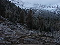
The Nabige Loch, a Hochkar under the slopes of the Seekofel
Dusk at the Faneshütte

Memorial chapel at Passo Falzàrego

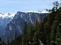
On Monte Averau
View from the Col del Orso

Evening mood at Passo Duràn

At the Rifugio Pramperét
View to the southwest shortly before the start of the Màrmol via ferrata


cards
- Tobacco hiking maps (1: 25,000), sheets 03, 031, 024 and 025
For the sake of completeness, further maps should be mentioned here which, despite the well-marked route, are not recommended due to their scale: Their accuracy is not sufficient if, after a bad weather with snowfall or fog, one is no longer in the landscape, but only on the The map or it is necessary to take another route.
- Compass hiking maps (1: 50,000), sheets 55, 57 and 77
- Freytag & Berndt hiking maps (1: 50,000), pages S10 and S15
- Carta d'Italia (1: 50.000), sheets “Dobbiaco”, “Cortina d'Ampezzo” and “Longarone”
- Tobacco hiking maps (1: 50,000), sheets 1 and 4
literature
- Franz Hauleitner: Dolomiten Höhenwege 1-3 (Rother hiking guide), Munich: Bergverlag Rother , 2018 (14th edition).
- Andreas Dick: Il Giro Grande - adventurous hikes through the southeastern Dolomites , in: Dieter Kreutzkamp: Roads to Solitude. South Tyrol - Trentino. Between the Ortles and the Dolomites, between Brenner and Trento. On shepherds' paths and quiet mountain paths along the sunny side of the Alps , Munich: Frederking & Thaler Verlag, 1999, pp. 55–60.
- Thomas Neubacher-Riens: Old Via - Mamma mia! , in: Alpin , Issue 12/2008, pp. 16–30 (tour report for stages 1 to 4)
- Eugen E. Hüsler : Death in the Dolomites. On a war climb through the "pale mountains" , in: Bergsteiger, Issue 12/2008, pp. 26–30 (including on the Little Lagazuoi / Stage 4).
- Horst Höfler , Paul Werner: Via ferrata Dolomites with Vicentine Alps, Brenta and Lake Garda mountains. Munich: Bergverlag Rother, 2000 (3rd, revised edition).
- Ulrike Kindl (ed.): Märchen aus den Dolomiten , Munich: Eugen Diederichs Verlag, 1992. (Fairy tales and legends that partly revolve around the Dolomites in general, partly very specific to individual mountains and areas such as the Fanes group or the Passo Falzarego The epilogue explains peculiarities of the Ladin narrative style and culture.)
Other sources
- Màrmol via ferrata. In: klettersteig.de. Retrieved August 18, 2020 .
- Seekofelhütte - Rifugio Biella. Retrieved August 18, 2020 (Italian).
Web links
- Toni Sanmarchi: Dolomite High Trail No. 1. (PDF; 2.2 MB) In: infodolomiti.it. 2005, accessed August 18, 2020 .
- Information and links to the Alpine Club huts
- Open-air museum at the Little Lagazuòi. Retrieved August 18, 2020 .
Coordinates: 46 ° 41 '51.8 " N , 12 ° 5' 2.4" E