
Erdmannsdorf (Augustusburg)
|
Erdmannsdorf
Augustusburg parish
Coordinates: 50 ° 49 ′ 16 ″ N , 13 ° 4 ′ 36 ″ E
|
||
|---|---|---|
| Height : | 306 m | |
| Area : | 6.48 km² | |
| Residents : | 1799 (Nov 2010) | |
| Population density : | 278 inhabitants / km² | |
| Incorporation : | January 1, 1999 | |
Location of Erdmannsdorf in Saxony |
||

Erdmannsdorf is a district of the city of Augustusburg in the district of central Saxony in the Ore Mountains .
geography
location

The place is on the west bank of the Zschopau and stretches west up the mountain to a height of about 390 m above sea level. NN. The federal road 180 and the state road 236 meet in the village .
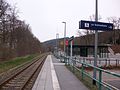
The Erdmannsdorf-Augustusburg stop (formerly the train station) of the Zschopautalbahn is on the east side of the river, as is the valley station of the Erdmannsdorf-Augustusburg cable car .

Hp. Erdmannsdorf-Augustusburg with valley station of the cable car (2016)
Hp. Erdmannsdorf-Augustusburg, view towards Flöha (2016)
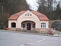
Augustusburg cable car, valley station building (2016)

.JPG)

Neighboring places
| Niederwiesa | Plaue | Grünberg |
| Euba |
.svg)
|
Augustusburg |
| Kunnersdorf | Waldkirchen |
_Schlo%C3%9F.jpg)
history

In the first documentary mentions from the year 1206 a Wern (h) erus de Ertmart (e) sdorf is mentioned in connection with a manor. The owners of the local manor at the time, which belonged to the Schellenberg office , those of Erdmannsdorff , exercised the manorial rights in the village. After the Mayor of Chemnitz , Ulrich Schütz, got rich through his participation in the Schneeberg silver mining and came into possession of the property in 1484, it was the family seat until 1821. The manor included a sheep farm, a brewery, two grinding mills, an oil mill and two cutting mills. In 1830 a castle was built on the site of the old manor house known as the stone house. For a long time, village life was linked to the history of the manor. A compulsory list from 1699 shows taxes and benefits of the residents. The Zschopau also offered work to some raftsmen .
After flax spinning, bleaching and dyeing were represented in old textile industries, the social structure of the place changed with the establishment of factories around 1830. The population grew rapidly. A spinning mill as well as a nail and rivet mill were built. From 1869 a cotton mill was in production, which became public property in 1953 .
Population development
|
|
|
Personalities
- Theophilus Friedrich Rothe (1785 in Erdmannsdorf; † 1837 in Leipzig), lawyer
- Richard von Könneritz (* 1828 in Erdmannsdorf; † 1910 in Wurzen ), manor owner, diplomat and politician
- Bruno Dürigen (* 1853 in Erdmannsdorf, † 1930 in Berlin ), zoologist and poultry expert
- Richard Büchner (* 1908 in Erdmannsdorf, † 1929 in Chemnitz ), chess composer
- Johannes Streubel (1921–1990), Rear Admiral of the People's Navy and longstanding director of the Army Museum in Dresden
- Peter Nagel (* 1938 in Erdmannsdorf), Protestant theologian, coptologist, classical philologist, Byzantinist and historian of religion
literature
- The middle Zschopau area (= values of our homeland . Volume 28). 1st edition. Akademie Verlag, Berlin 1977, pp. 92–95.
- Municipal administration Erdmannsdorf (Ed.): 1196–1996, 800 years Erdmannsdorf . Erdmannsdorf 1996
- Richard Steche : Erdmannsdorf. In: Descriptive representation of the older architectural and art monuments of the Kingdom of Saxony. 6th booklet: Amtshauptmannschaft Flöha . CC Meinhold, Dresden 1886, p. 63.
Web links
- Erdmannsdorf in the Digital Historical Directory of Saxony
Individual evidence
- ↑ Data / facts on augustusburg.de ( memento from January 18, 2015 in the Internet Archive ), accessed on January 17, 2011
- ↑ Ernst Eichler , Hans Walther (ed.): Historisches Ortnamesbuch von Sachsen , Berlin 2001, Volume I, p. 246, ISBN 3-05-003728-8
- ↑ a b c Georg Fritzsche: Erdmannsdorf in: Values of our homeland, The middle Zschopau area, Volume 28, Berlin 1977, pp. 92–95
- ↑ Erdmannsdorf in the Historical Directory of Saxony
- ↑ cf. Erdmannsdorf in the Digital Historical Directory of Saxony

Augustusburg | Erdmannsdorf | Grünberg | Hennersdorf | Kunnersdorf