
Cottbus Baltic Sea
|
Cottbus Baltic Sea / Chóśebuski pódzajtšny jazor |
||
|---|---|---|

|
||
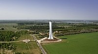
| Cottbus Baltic Sea from the west (September 2019) | ||
| Geographical location | City of Cottbus , Spree-Neisse district | |
| Tributaries | Glötschergraben , Hammergraben , Haasower Landgraben , Lakoma , Tranitzfließ and Wildwasserbach | |
| Drain | Freigraben , Hammergraben , Randgraben and Schwarzer Graben | |
| Islands | Little Bornholm | |
| Places on the shore | Lakoma , Neuendorf , Merzdorf , Schlichow and Willmersdorf | |
| Location close to the shore | Cottbus , Bärenbrück and Haasow | |
| Data | ||
| Coordinates | 51 ° 47 '15 " N , 14 ° 25' 56" E | |
|
||
| Altitude above sea level | 61.8 m | |
| surface | 19 km² | |
| Maximum depth | 30 m | |
| Middle deep | 2.5 m | |
|
particularities |
artificially created lake, open pit residual lake |
|


The Cottbus Baltic Sea , Chóśebuski pódzajtšny jazor in Lower Sorbian , is a project in which the former Cottbus-Nord open-cast lignite mine has been flooded since April 12, 2019. With 1900 hectares, the largest lake in the Lausitz open-cast mine area and the largest artificial lake in Germany are to be created by 2024 . Due to three years of drought since 2018, the plans have stalled. Shortly after the start of the flooding, it had to be interrupted, currently (as of July 2020) the flooding has been restricted for months.
History of the open pit

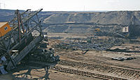
The Cottbus-Nord open-cast mine was the smallest of the five Vattenfall open-cast mines with around 83 million tons of extractable lignite (as of 2000) and was used exclusively to supply the Jänschwalde power plant with additional supplies . The seam height was about eight to eleven meters with an excavation thickness of 32 to 40 meters. The annual coal output from the open pit was around four million tons ( as of 2008 ).
On December 23, 2015, the last coal train left the Cottbus-Nord opencast mine. As an open pit operator, Vattenfall was obliged to recultivate . LEAG took on this obligation by selling Vattenfall's German lignite division .
Conversion to the lake
Structural measures
In 2001, in a Europe-wide competition, a collection of ideas was developed, from which a master plan for the design of the 1900 hectare (19 km²) lake and the surrounding bank sections was created. On August 24, 2009, the groundbreaking ceremony for the future extensive bank reinforcements at the southeast corner of the opencast mine took place. The first visible sign of the new landscape is a 34 meter high observation tower on the western edge of the opencast mine. In July 2010, a second observation tower was completed on the east side of the future lake (Bärenbrücker Höhe).
The Seeallee, a traffic connection from the city to the lake on a former section of the Cottbus-Guben railway line, which had long been advertised by the city of Cottbus , was discarded in 2011. Instead, alternative transport connections were created between September 2011 and March 2012.
Landslides are to be expected during the filling process , as happened with other opencast mining holes ( list of landslides in mining ).
The plans for the lake include several marinas, a ferry connection Cottbus-Neuendorf and several beaches. A leisure park with a summer toboggan run, a so-called Götterhain (sculpture park with ancient Slavic gods) and other attractions was built in the future municipality of Teichland , which will be located on the eastern lakeshore near Neuendorf .
Flooding
Initially, the flooding should begin at the end of 2018, but the water level in the Spree was too low due to the dry summer . A test run for the water inlet took place in January 2019. The remaining open pit after the cessation of coal mining in December 2015 has been flooded since April 2019. The inlet branches off the Hammergraben in Lakoma in the south of the Cottbus district of Wilmersdorf .
Since the rising groundwater cannot fill the lake sufficiently quickly, only around 12% of the water volume of the lake's content should flow in from the groundwater. It is intended to discharge up to 30 million m³ of Spreewater annually over a period of ten years . When the lake is completely filled, it will have a volume of 150 million m³ of water. It will be about 2.5 to 3 meters deep, at some edge sections up to 30 meters deep. According to initial official estimates, the flooding should be completed in 2030 .
After a trial flooding from April 12, 2019, it was suspended again after a week due to the persistent drought in the region. Flooding was resumed on December 18, 2019. After some rainfall, the amount of water was increased to up to 4 m³ / s in February 2020. The amount of water is adjusted every Tuesday after approval. As of March 2020, the lake has already been filled to 35% of the fill level (not the volume) since flooding began.
criticism
The Green League criticized the project in 2015. It primarily affects hydrological issues. In addition to a deterioration in the climatic water balance in the Lausitz, the association also expected an increase in the sulphate content of the Spree , which would endanger drinking water for parts of Berlin. The already existing ossification of parts of the Spree could spread to the Spreewald .
Responsible utilities for the city of Frankfurt (Oder) feared increasing pollution from sulfates at the beginning of the flooding. In the opinion of the Brandenburg State Office for Mining, Geology and Raw Materials, however, the sulphate pollution could even decrease due to the elimination of the groundwater lowering required during open-pit mining .
Name of the lake
The Cottbus Baltic Sea has finally been named after a decision by the Cottbus city council since May 30, 2013. It came up in 1998 as part of a workshop on the development of the Merzdorf district. The Inselrat, founded in 2002 with representatives of the communities bordering the opencast mine and the advisory members of the Willmersdorf, Merzdorf and Dissenchen local councils, agreed in December 2012 to be named "Cottbuser Ostsee".

Lake environment and tourism
In July 2016, a marketing company and people living near the future lake presented a potential analysis. This analysis was based on realistic environmental variables and reduced the pre-planning projects to a level that could be reached by consensus. Some projects have been canceled, others have been adapted to the actual needs forecast.
Nevertheless, the question of who will be the owner of what will be the largest lake in Brandenburg in the future had not yet been answered by this date. The state of Brandenburg kept the option open of operating the lake as a storage basin with constantly fluctuating water levels. This scenario alone could have endangered many of the projects presented in the potential analysis or required their revision.
In July 2016, the Federal Ministry of Construction supported the urban development competition for the Cottbus harbor district on the future lake with 180,000 euros.
Although the Cottbus Baltic Sea was only flooded from 2019, the "Baltic Sea Festival" took place annually in previous years in honor of the future lake. It wandered around the future lake from year to year. In 2014, Mouse hosted the celebrations in the Teichland community .
Ports
Neuendorf
At the end of August 2012, the architecture competition for the Neuendorfer Baltic Sea port was decided. According to the plan, the port should cover an area of 14,800 m², with jetties and berths for around 120 boats. The concept was based on a harbor bay with several offshore islands; A hotel accessible via a bridge was to be built on the largest. The harbor background area with boat sheds, shops and single-family houses should cover around three hectares.
Work on the "sea axis" has already started. Before the start of flooding of the lake (planned at the time: 2018), a considerable part of the construction work should be completed.
Cottbus city harbor
On January 30, 2018, the city administration of Cottbus announced that the design by the Hamburg architects Fehlig & Moshfegi had won first prize in the urban development competition “Hafenquartier Cottbus”. All competition designs were exhibited in the Cottbus town hall from February 2, 2018. In July 2018, a ceremony took place at which Brandenburg's Minister of Infrastructure, Kathrin Schneider (SPD), set the symbolic first pile-up for the quay wall. After a construction delay due to poor concrete quality, the completion of the quay wall and the harbor basin was planned for mid-2019 in January 2019. The construction of the new quay wall was finally completed on August 25, 2019, and the quay wall was presented to the public as part of the 14th Baltic Sea Festival.
timeline

| date | event | Location |
|---|---|---|
| 2006 | Completion of the Merzdorf observation tower , 34 m high, 173 steps | Cottbus-Merzdorf |
| June 25, 2006 | The 1st Baltic Sea Festival, at that time still part of the International Building Exhibition Fürst-Pückler-Land , gets Cottbus in the mood for their future lake. | Cottbus-Merzdorf, train station / railway line |
| September 10, 2006 | Inauguration of the honor grove for firefighters who have died while on duty | North bank |
| Summer 2008 | Completion of the amusement park "Erlebnispark Teichland" u. a. with summer toboggan run, mini golf, climbing rock | Bärenbrücker Höhe |
| Summer 2009 | The Cottbus-Nord opencast mine (after passing Cottbus-Merzdorf) makes a bend to the north to the last stage of the opencast mine. The area of the former village of Lakoma and its pond area is "run over" | North bank |
| August 24, 2009 | First groundbreaking for the bank design of the lake | Southeast bank |
| June 12, 2010 | Inauguration of the memorial for the excavated village of Tranitz | Northeast at the wind farm |
| July 17, 2010 | Inauguration of the second observation tower / museum (57 m high, 272 steps) as part of the 5th Cottbus Baltic Sea Festival | Neuendorf (Teichland) |
| Sept 2011 - March 2012 | Extensive bank design from Schlichow to Cottbus, around the Merzdorf observation tower | Cottbus-Merzdorf south bank |
| June 9, 2012 | Inauguration of the memorial for the devastated places Groß- and Klein Lieskow between 1976 and 1984 | South-east bank east of Schlichow |
| 3rd September 2012 | Inauguration of the first section of the Cottbus bypass, which is also the transport connection to the future Cottbus beach | near Merzdorf |
| Fall 2012 | Completion of the embankment of the future beach area on the south-east bank | Schlichow to Merzdorf |
| May 30, 2013 | Official naming "Cottbuser Ostsee" by the city of Cottbus and the neighboring communities. The confirmation from the owner State of Brandenburg is still pending. | |
| 23rd December 2015 | Cessation of open-cast mining | Cottbus-Nord opencast mine |
| from February 2015 | Start of embankment work on the west bank between Merzdorf and Lakoma. | between Merzdorf and Lakoma |
| March 3, 2016 | Demolition of the overburden conveyor bridge F34. It was in use for 32 years and was the last of its kind. 24 kg of explosives, distributed in 150 places on the conveyor bridge, were required. | near Neuendorf |
| 6./7. July 2016 | Presentation of a potential analysis of the Cottbus Baltic Sea commissioned by the city of Cottbus , a joint effort by two companies | Cottbus town house |
| December 2016 | Completion of the vibration pressure compaction work on the southern embankment of the future Cottbus Baltic Sea. Over an area of 1.2 km in length and up to 108 m in width, around 3.4 million m³ of earth was compacted into a supporting body. 140,000 cubic meters of earth were added to compensate for the compression. | South embankment |
| 2nd June 2017 | First groundbreaking for the construction of the Baltic Sea inlet, which is to create the connection from the Spree to the Cottbus Baltic Sea. 80% of the lake water should run into the lake via this connection. The inlet was completed in October 2018 and successfully tested in January 2019. | at Lakoma |
| 20th March 2018 | The city of Cottbus and LEAG sign a purchase agreement and thus lay the foundation for the construction of the Cottbus quay wall. Cottbus has the right to own properties in the Baltic Sea port. | cottbus |
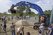
| July 9, 2018 | Symbolic first ramming for the construction of the Cottbus quay wall in the presence of representatives of the city's top, the LEAG and the Brandenburg Minister for Infrastructure and Regional Planning Kathrin Schneider. Around 92,000 cubic meters of earth will be moved to build the 820 m long quay wall. The completion of the quay wall and the harbor basin is planned for mid-2019. | Cottbus-Merzdorf |
| January 2019 | The start of flooding will be postponed a second time due to construction delays on the Cottbus quay wall. The date had already been postponed indefinitely in the summer due to the water shortage. However, in mid-January 2019, the LEAG tested the intake structure for the flooding for a week. | Inlet structure near Lakoma |
| April 12, 2019 | Official start of flooding. Representatives of the LEAG (board member Helmar Rendez), the city of Cottbus (Mayor Holger Kelch) and the state of Brandenburg (Prime Minister Dietmar Woidke) pressed a button together and thus initiated the flooding. | Inlet structure near Lakoma |
| April 26, 2019 | 14 days after the start of flooding, the supply of Spree water to the lake was stopped again. The reason is the extreme drought that has persisted since the previous year and the associated low water levels. | Cottbus, LEAG |
| 20th August 2019 | The work on the quay wall at the future Cottbus harbor, which cost around 7 million euros, has been completed. | Cottbus, harbor area |
planning
| Type | place | completion |
|---|---|---|
| Ports | Cottbus city harbor, Neuendorfer harbor | |
| Ferry dock | Cottbus harbor, Neuendorf harbor | |
| beaches | Cottbuser, Merzdorfer Surfstrand, Willmersdorfer, Jugendorf (Neuendorf), Neuendorfer, Bärenbrücker Bucht | |
| Campsites | Willmersdorf, Jugendorf (Neuendorf) | |
| deleted projects from previous plans | Dissenchen inland port, Merzdorf floating stage, Schlichow golf course, wild water run, connection between Klinger See and Baltic Sea, Lakoma harbor (as of July 2016) |
gallery


August 24, 2009: The starting shot for the construction work on the bank reinforcement on the southeast corner of the future lake
Neuendorf observation tower with summer toboggan run, maze and "Slavic grove of gods" (April 2011)
Blasted overburden conveyor bridge F34 (March 4, 2016)
Symbolic first ramming for the construction of the quay wall near Merzdorf on the Cottbus Baltic Sea on July 9, 2018


See also
Web links
- Website of the city of Cottbus about the Cottbus Baltic Sea
- Website for planning the Cottbus Baltic Sea
- Website of the adventure park Teichland
- LEAG website
- Observation tower adventure park Teichland. In: Structurae
Individual evidence
- ↑ Flooding of Cottbus Nord opencast mine has started
- ↑ a b c BALTIC SEA FLOODING IS THE STARTING GOT FOR COTTBUSER PERSPECTIVES. Retrieved April 15, 2019 .
- ↑ Peggy Kompalla: Water March for the Baltic Sea. Lausitzer Rundschau , April 13, 2019. Accessed the same day.
- ↑ Environment Minister classifies the situation in waters as "super serious". In: rbb24.de. August 13, 2020, accessed on August 13, 2020 .
- ↑ The Cottbus Baltic Sea runs out of water - before it is there. In: rbb24.de. July 16, 2020, accessed August 13, 2020 .
- ↑ Cottbus-Nord opencast mine , data sheet from Vattenfall Europe Mining AG.
- ↑ Peggy Kompalla: Vattenfall closes the Cottbus-Nord opencast mine on schedule. Last trip out of the pit - start for the Baltic Sea. December 24, 2015, accessed February 10, 2016 .
- ↑ Master plan ( Memento from April 22, 2016 in the Internet Archive ) (PDF; 705 kB)
- ↑ Flooding of the Baltic Sea begins on Friday. In Der Tagesspiegel on April 11, 2019. Retrieved on April 14, 2019
- ↑ Cottbuser Ostsee: Ex-opencast mine ready for flooding. Retrieved December 23, 2018 .
- ↑ Lausitz360: Water March - Test run in Lakoma - Cottbuser Ostsee water supply January 2019. Accessed on January 18, 2019 .
- ^ Süddeutsche Zeitung: Water flows again in Cottbus Baltic Sea: no flooding. Retrieved March 9, 2020 .
- ↑ Cottbus Baltic Sea | How a new lake is created. Retrieved March 9, 2020 .
- ↑ The Cottbuser Ostsee flooding is less likely. Retrieved April 18, 2018 .
- ↑ Cottbuser Ostsee - The citizen should pay the bill. (PDF) Green League , accessed on April 18, 2018 .
- ↑ Frankfurt fears drinking water problems due to the Cottbus Baltic Sea. rbb24 , accessed April 13, 2019 .
- ↑ Cottbus Baltic Sea Festival in Mouse
- ↑ A face for the city harbor. Retrieved November 19, 2018 .
- ↑ Peggy Kompalla: The former opencast mine is becoming Brandenburg's largest lake: the construction of the quay wall for the Baltic Sea is behind schedule. Retrieved February 23, 2019 .
- ^ New quay wall for the future city harbor - Baltic Sea Festival in Schlichow. Accessed January 1, 2020 .
- ↑ TOPOS urban planning, landscape planning, urban research and PROJECT M GmbH
- ↑ Source: LMBV Konkret, Volume 22, February 2017, p. 4)
- ↑ Peggy Kompalla: The former opencast mine is becoming Brandenburg's largest lake: the construction of the quay wall for the Baltic Sea is behind schedule. Retrieved February 23, 2019 .
- ↑ Peggy Kompalla: The former opencast mine is becoming Brandenburg's largest lake: the construction of the quay wall for the Baltic Sea is behind schedule. Retrieved February 23, 2019 .
- ↑ NTV regional news of April 12, 2019: Birth of the largest lake in Brandenburg: open-cast mine flooded . Retrieved April 14, 2019