Eureka County
 Eureka County Courthouse |
|
| administration | |
|---|---|
| US state : | Nevada |
| Administrative headquarters : | Eureka |
| Foundation : | 1873 |
| Demographics | |
| Residents : | 1987 (2010) |
| Population density : | 0.2 inhabitants / km 2 |
| geography | |
| Total area : | 10,826 km² |
| Water surface : | 11 km² |
| map | |
| Website : www.co.eureka.nv.us | |
Eureka County is a county in the state of Nevada in the United States . The county seat is Eureka .
history
Eureka County was formed from eastern Lander County in 1873 after silver was discovered more than 100 miles east of Austin . The new county was formed after residents of the new settlement near the mines complained that Austin was too far away for most business. It got its name from the Greek word " Eureka ", which means "I have found". The administrative center is the small town of Eureka with 650 inhabitants .
Near the western border of the district is the small rail and freight loading station Beowawe , which reached its peak in 1881 with 60 inhabitants, along with a few geysers . In 1985 a power plant for the use of geothermal energy was built in the vicinity . For decades, Eureka County was the scene of bitter land rights battles between the Western Shoshone Indians and the US government, for which the two sisters and ranchers Mary and Carrie Dann from Crescent Valley became famous.
One place in the county is listed on the National Register of Historic Places (as of February 14, 2018), the Eureka Historic District .
geography
According to the US Census Bureau , the county's area is 10,826 square kilometers; 11 square kilometers are water.
Demographic data
| growth of population | |||
|---|---|---|---|
| Census | Residents | ± in% | |
| 1880 | 7086 | - | |
| 1890 | 3275 | -53.8% | |
| 1900 | 1954 | -40.3% | |
| 1910 | 1830 | -6.3% | |
| 1920 | 1350 | -26.2% | |
| 1930 | 1333 | -1.3% | |
| 1940 | 1361 | 2.1% | |
| 1950 | 896 | -34.2% | |
| 1960 | 767 | -14.4% | |
| 1970 | 948 | 23.6% | |
| 1980 | 1198 | 26.4% | |
| 1990 | 1547 | 29.1% | |
| 2000 | 1651 | 6.7% | |
| 2010 | 1987 | 20.4% | |
| 1900–1990 2000 + 2010 | |||


According to the 2000 census , the county had 1,651 people. There were 666 households and 440 families. The population density was less than 1 person per square kilometer. The racial the population was composed of 89.28% White, 0.42% African American, 1.57% Native American, 0.79% Asian, 0.06% Pacific Islander, and 4.36% other races Groups; 3.51% were from two or more races. Hispanic or Latino of any race was 9.57% of the population.
Of the 666 households, 33% had children under the age of 18 living with them. 56.5% were married couples living together, 5% were single mothers. 33.9% were not families. 29.1% were single households and 9.9% had someone who was 65 years of age or older. The average household size was 2.47 and the average family size was 3.08.
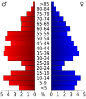
For the entire county, the population was composed of 27.8% residents under 18 years of age, 5.2% between 18 and 24 years of age, 28.6% between 25 and 44 years of age, and 25.9% between 45 and 64 years of age 12.4% were 65 years of age or over. The median age was 38 years. For every 100 females there were 106.60 males, and for every 100 females aged 18 and over there were 113.20 males.
The median income for a household in the 41,417 US dollars , and the median income for a family was 49,438 US dollars. Males had a median income of $ 45,167 and women $ 25,000. The per capita income was $ 18,629. 12.6% of the population and 8.9% of families are below the poverty line. 11.7% of these were under 18 years of age and 16.4% were 65 years of age or older.
Places in the county
Individual evidence
- ↑ GNIS-ID: 858640. Retrieved on February 22, 2011 (English).
- ↑ Search mask database in the National Register Information System. National Park Service , accessed February 14, 2018.
- ↑ Extract from Census.gov. Accessed February 28, 2011
- ↑ Excerpt from census.gov (2000 + 2010) ( Memento of the original from July 10, 2011 on WebCite ) Info: The archive link was inserted automatically and has not yet been checked. Please check the original and archive link according to the instructions and then remove this notice. Retrieved April 13, 2012
Web links
Coordinates: 39 ° 59 ′ N , 116 ° 16 ′ W

