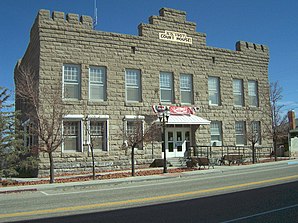
Esmeralda County
 Esmeralda County Courthouse |
|
| administration | |
|---|---|
| US state : | Nevada |
| Administrative headquarters : | Goldfield |
| Foundation : | 1861 |
| Area code : | 001 775 |
| Demographics | |
| Residents : | 783 (2010) |
| Population density : | 0.1 inhabitants / km 2 |
| geography | |
| Total area : | 9295 km² |
| Water surface : | 1 km² |
| map | |
| Website : www.accessesmeralda.com | |
The Esmeralda County is a county in the west of the state of Nevada of the United States . The county is the least populous county in Nevada. The county seat is in Goldfield .
history
Esmeralda County is one of the original counties founded in Nevada in 1861. The name is derived from the Spanish word Esmeralda for emerald . He was selected by JM Corey who co-founded and named the Esmeralda Mining District . Initially, Aurora was the administrative seat, from 1883 Hawthorne . It has been Goldfield since 1907.
The county grew rapidly due to a gold rush in the early 20th century. The mines were exhausted by the end of the 1910s, and the economy and population declined significantly.
One place in the county is listed on the National Register of Historic Places (as of February 13, 2018), the Goldfield Historic District .
geography
The county is located in southwest Nevada, on the California border , halfway between Reno and Las Vegas . Mark Twain described the area and miner work in the area in his 1872 book Roughing It . The county is home to the Silver Peak Range and Monte Cristo Range , which dominate the county. The highest peaks include:
- Boundary Peak : 4007 m, highest point in Nevada
- Piper Peak : 2880 m
- Magruder Mountain : 2756 m
- Montezuma Peak : 2552 m
- Emigrant Peak : 2069 m
Demographic data
| growth of population | |||
|---|---|---|---|
| Census | Residents | ± in% | |
| 1870 | 1533 | - | |
| 1880 | 3220 | 110% | |
| 1890 | 2148 | -33.3% | |
| 1900 | 1972 | -8.2% | |
| 1910 | 9369 | 375.1% | |
| 1920 | 2410 | -74.3% | |
| 1930 | 1077 | -55.3% | |
| 1940 | 1554 | 44.3% | |
| 1950 | 614 | -60.5% | |
| 1960 | 619 | 0.8% | |
| 1970 | 629 | 1.6% | |
| 1980 | 777 | 23.5% | |
| 1990 | 1344 | 73% | |
| 2000 | 971 | -27.8% | |
| 2010 | 783 | -19.4% | |
| Before 1900
1900–1990 2000 + 2010 |
|||

As of the 2000 census , the county had 971 people. There were 455 households and 259 families. The population density was less than 1 person per square kilometer. The racial the population was composed of 81.98% White, 0.10% African American, 5.15% Native American, 0.00% Asian, 0.21% Pacific Islander, and 7.62% other races Groups; 4.94% were from two or more races. Hispanic or Latino of any race was 10.20% percent of the population.
Of the 455 households, 21.10% had children and adolescents under the age of 18 living with them. 46.40% were married couples living together, 6.40% were single mothers. 42.90% were not families. 36.00% were single households and 13.20% had someone who was 65 years of age or older. The average household size was 2.02 and the average family size was 2.79 people.
For the entire county, the population was made up of 20.50% residents under 18 years of age, 6.00% between 18 and 24 years of age, 23.40% between 25 and 44 years of age, and 33.00% between 45 and 64 years of age 17.20% were 65 years of age or over. The median age was 45 years. For every 100 females there were 123.70 males, for every 100 females aged 18 and over there were 118.70 males.
The median income for a household in the 33,203 USD , and the median income for a family was 40,917 USD. Males had a median income of $ 39,327 versus $ 25,469 for females. The per capita income was $ 18,971. 15.30% of the population and 7.50% of families are below the poverty line. 9.70% of them were under 18 years of age and 11.40% were 65 years of age or older.
Places in the county
prostitution
The county is one of Nevada's eleven counties that allow prostitution and brothel building .
Streets
Individual evidence
- ↑ GNIS-ID: 858641. Retrieved on February 22, 2011 (English).
- ↑ Search mask database in the National Register Information System. National Park Service , accessed February 13, 2018.
- ↑ US Census Bureau - Census of Population and Housing . Retrieved March 15, 2011
- ↑ Extract from Census.gov . Retrieved February 28, 2011
- ↑ Excerpt from census.gov (2000 + 2010) ( Memento of the original from July 10, 2011 on WebCite ) Info: The archive link was inserted automatically and has not yet been checked. Please check the original and archive link according to the instructions and then remove this notice. Retrieved April 13, 2012
Web links
Coordinates: 37 ° 47 ′ N , 117 ° 38 ′ W


