
Extreme points of the European Union

Since the founding of the European Union , the area has been expanded several times, so that the external borders and thus the extreme points are constantly changing. New members want to be admitted and the United Kingdom is fighting to leave (Brexit).
Overview
|
|
including overseas territories |
in Europe |
continental Europe |
|
|
|---|---|---|---|---|---|
  |
 |
 |
 |
 the euro |
|
| North |
Nuorgam , Lapland , Finland (70 ° 5'30 ”N) |
Knivskjellodden , Magerøya , Finnmark , Norway (71 ° 11'8 "N) |
Nuorgam, Lapland, Finland | ||
| south |
Pointe de Langevin , Saint-Joseph , Réunion , French Overseas Territory (21 ° 23'23 "S) |
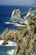
Cape Trypiti ( Greek Τρυπητή ) , Gavdos , Greece (34 ° 48'03 "N) |
Isla de Las Palomas , Punta de Tarifa , Spain (36 ° 0'0 ”N) |
Punta de los Saltos , La Restinga , El Hierro , Canary Islands , Spain (27 ° 38'16 "N) |
Pointe de Langevin, Saint-Joseph , French overseas territory |
| west |
Pointe du Canonnier , Saint-Martin , French Overseas Territory ( 18 ° 4 ′ N , 63 ° 9 ′ W )
|
An Tiaracht , County Kerry , Ireland (10 ° 39'45 "W) |
Cabo da Roca , Sintra , Portugal (9 ° 30'03 "W) |
Pointe du Canonnier, Saint – Martin , French overseas territory |
Ilhéu do Monchique , Azores , Autonomous Region of Portugal (31 ° 16'32 "W) |
| east |
Pointe des Cascades , Sainte-Rose , Réunion , French Overseas Territory ( 21 ° 11 ′ S , 55 ° 50 ′ E ) |
Virmajärvi , North Karelia , Finland ( 62 ° 55 ' N , 31 ° 35' O )
|
Virmajärvi, North Karelia, Finland |
Pointe des Cascades, Sainte-Rose , Réunion, French overseas territory |
|
| ⊙ |
Veitshöchheim - Gadheim Bavaria Germany ( 49 ° 51 ′ N , 9 ° 54 ′ E ) |
estimated at Lehrberg , Middle Franconia , Bavaria, Germany ( 49 ° 22 ′ N , 10 ° 31 ′ E ) |
Villy-en-Auxois , Côte-d'Or , Bourgogne-Franche-Comté , France ( 47 ° 22 ′ N , 4 ° 38 ′ E ) |
||
Remarks
- ↑ The northernmost point of Finland is also in the valley route ⊙ of the Norwegian-Finnish border river Tenojoki ( Norwegian Tana ) near Nuorgam . There is a memorial stone at the road border crossing ⊙ .
- ↑ Theoretically, the North Cape would be near Atlantic City (1943–1945, now two radio and direction finding stations) on the island of Jan Mayen (71 ° 09'37 "N) . Except for a few researchers, the island is uninhabited.
- ↑ a b Réunion in the Indian Ocean is one of the five French overseas departments that are all full members of the EU.
-
↑ a b c The easternmost point of the EU countries and the euro area without French overseas territories is de facto Cape Greco on the east coast of the Republic of Cyprus at 34 ° 58 ' N , 34 ° 5' O . Thus this point is also 126 km further east than the east point in Finland. In law would result without the occupation of northern Cyprus by Turkey an even 47 km to the east point lying on the Cape Apostolos Andreas upstream Klidhes Islands at 35 ° 43 ' N , 34 ° 36' O .

- ↑ a b not meaningfully calculable
-
↑ Gadheim, 80 inhabitants, center of the EU - thanks to Brexit in: sueddeutsche.de
Veitshöchheim: Gadheim will be the new center of the EU 03/30/2017 Bayernreporter - ↑ An exact current calculation is not available. The estimate takes into account the south-west shift through the Portuguese and Spanish islands, taking into account the intervening sea space as of 2013.
-
↑ The center of the Eurozone in France is in different places at different periods.


1999 2002 2007 2008 2009 since 2011 Centers of the Eurozone
Corner map: Center-Val de LoireAt times he was in or near
- 1999 Blancafort 47 ° 32 ′ 0 ″ N , 2 ° 31 ′ 53 ″ E
- 2002 Montreuillon 47 ° 10 ′ 29 ″ N , 3 ° 47 ′ 20 ″ E
- 2007 Mhère 47 ° 12 '25.5 " N , 3 ° 51' 22.7" E
- 2008 Ouroux-en-Morvan 47 ° 11 ′ 11 " N , 3 ° 56 ′ 47" E
- 2009 Liernais 47 ° 11 ′ 11 ″ N , 4 ° 16 ′ 58.8 ″ E
- Since 2011 Villy-en-Auxois 47 ° 22 ' N , 4 ° 38' O - With the accession of new countries to the area of the euro, the point moves.


gallery

Northernmost point of the EU

Globe on the North Cape

Marking on the Knivskjellodden

View of Tarifa from Cape Punta Tarifa

Cyprus: Cape Greco

Europe's westernmost point

Cabo da Roca / View of the Atlantic

Oberwestern: EU focus before Brexit
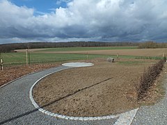
Gadheim: EU focus after Brexit

Isla de las Palomas
Cabo da Roca

Finland's most easterly point


See also
- European Union territory
- Schengen area
- Eurozone
- History of the European Union
- Center of Europe
- Geographical extreme points of Europe
- External borders of the European Union
- European Council
- Political system of the European Union
- EU enlargement
- UK withdrawal from the EU
- List of European non-EU countries