Fgura
| coat of arms | map |
|---|---|

|
|
| Basic data | |
| State : | Malta |
| Gzejjer : | Malta Xlokk (Southeast Malta) |
| Distretti : | Southern Harbor |
| Area : | 1,142,706 km² |
| Residents : | 12,449 (December 31, 2018) |
| Population density : | 10,894 inhabitants / km² |
| ISO 3166-2 : | MT-08 |
| Postal code : | FGR |
| Website : | lc.gov.mt/Page.aspx?catid=37&pid=184 |
| politics | |
| Mayor : | Byron Camilleri ( MLP ) |
Coordinates: 35 ° 52 ' N , 14 ° 31' E
Fgura (or Il-Fgura ) is a medium-sized city in Malta . It has one of the 68 “Local Councils”.
On the surface, Fgura appears to be a newly built city in the 1960s. But the external appearance hides the ancient origins. The city has prehistoric roots - and it seems that it was a Phoenician- era settlement . Between October 28 and December 21, 1948, six Phoenician graves were found in Fgura - most of them on Liedna Street. These graves can be dated to the 3rd or 4th century BC. Their appearance was unusual and human skeletons, remains of animals, pottery shards and other materials and finds from the Bronze Age were found . A street in the city was named “Triq is-Sejba Punika” in memory of the Phoenician finds.
Fgura, which lies inland behind the “Three Cities”, was influenced by the growth of shipyards, especially after World War II . The northern outskirts are formed by the "Cottonera Lines" (fortification lines); in the south the city borders on Żabbar and in the west on Tarxien . Today Fgura has one of the highest population densities in the country. It recently expanded to the areas adjacent to the Great Port and is one of the fastest growing cities in Malta. Fgura became one of the most important trading centers in the south of the island.
The city coat of arms of Fgura consists of a horizontal red stripe with three gold, five-pointed stars, a cross in the middle and a white background. The city saint of Fgura is Our Lady of Mount Carmel (Maria) and her annual festival is celebrated on the second Sunday in July. Fgura also has one of the most peculiar churches in Malta, built in the shape of a tent.
Attractions
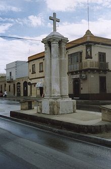
Il-Monument tas-Salib (The Cross Monument)
In Hompesch Street there is a monument that the population calls "Il-Monument tas-Salib". It was inaugurated in February 1990 when Fgura celebrated 25 years of elevation to the city in 1965. It was designed by sculptor Ġanni Bonniċi and built by students from Ġlormu Cassar School.
The memorial was erected exactly where the small church Our Lady of Mount Carmel was built in 1790.
The monument sits on four pillars, each of which has a special meaning. Three of the pillars symbolize the three neighboring cities Paola , Tarxien and Żabbar , parts of which were united to form the new municipality of Fgura. The fourth symbolizes the municipality of Fgura. There are four tombstones on the foundation of the monument. They commemorate the 25th birthday of Fgura parish, the inauguration of the monument and one is a copy of another tombstone that was on a church built in 1844. The lettering on this tombstone is in Latin and describes the history of this church.
Reggie Miller Gardens
This garden was named after Reggie Miller, founder of the General Workers 'Union, and was inaugurated on March 28, 1976 by Lorry Sant, Minister of the Workers' Party and a resident of Fgura. Originally there was a fish pond there, which was surrounded by large pebbles. There was also a sundial by Paul Ignatius Micallef. But this work was removed when Fgura City Council managed to raise some money and modernize the garden.
George Stevens Square
On Saturday, September 6, 1986, Minister Lorry Sant inaugurated a memorial named after George Stevens, co-founder of the Maltese Literary Society. This was the company's 35th birthday. The monument that gave the square its name was designed by the sculptor Alfred Camilleri Cauchi and consecrated by the parish priest, Father Guido Micallef.
Some historical facts
The name "Fgura" probably comes from the Maltese word "figura" (figure). Before Fgura became its own parish, it was a suburb of Tarxien. Before World War II , Fgura was a farming village made up of a few scattered farmhouses (practically nothing left) near the new church (see above) and the new school on St. Thomas Street. There were about 20 families there.
population
After the Second World War , the farming village of Fgura became one of the most densely populated places in Malta. During the war, many people from Cottonera and Cospicua moved to the Great Port of Fgura, which was a few kilometers inland. This is how they escaped the bombing and yet lived near their birthplaces.
In 1939 Fgura had only 500 inhabitants. In the city census of 1965 there were 2,500. In 1995 there were 10,922 inhabitants and on December 31, 2018 there were 12,449.
Web links
Individual evidence
- ↑ StatDB of the National Statistics Office Malta , accessed on August 1, 2020


