
Mellieħa
| coat of arms | map |
|---|---|

|
  |
| Basic data | |
| State : | Malta |
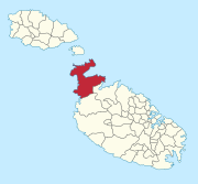
| Gzejjer : | Malta Majjistral (Northwest Malta) |
| Distretti : | Northern |
| Area : | 22,644.39 km² |
| Residents : | 11,389 (December 31, 2018) |
| Population density : | 503 inhabitants / km² |
| ISO 3166-2 : | MT-30 |
| Postal code : | MLH |
| Website : | www.mellieha.gov.mt |
| politics | |
| Mayor : | Robert Cutajar ( PN ) |
Coordinates: 35 ° 57 ' N , 14 ° 22' E
Mellieħa ( Maltese il-Mellieħa [ ɪl mɛˈlːɪːħɐ ]) is a rural, touristic small town in the Republic of Malta with 11,389 inhabitants (as of December 31, 2018). It is located in the northwest of the island on a hill between St. Paul's Bay and Mellieħa Bay . The uninhabited Saint Paul's Islands also belong to the community .
history

Finds of simple tools and tombs suggest that Mellieħa has been around since 3000 BC. Was inhabited.


During the Roman and Byzantine occupation of Malta (approx. 210 BC to 870 AD), mainly farmers and fishermen lived in the region around Mellieħa. Mainly natural caves served as dwellings. During the time of the Arab occupation (870 to 1127 AD), the Mellieħa region was abandoned by the inhabitants.
During the reign of the Johanniter (1530-1798) Mellieħa was gradually repopulated. The Chapel of the Blessed Virgin Mary, which was built at that time and still partially preserved today, served as a pilgrimage site for the inhabitants of Malta. It contains a depiction of Mary painted directly on the rock, which according to legend is said to come from the Evangelist Luke , but which was not actually made until the 13th century.
The British seizure of power in Malta around 1800 led to a sustainable resettlement of Mellieħa.
Economy and Importance
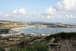
Today Mellieħa's main source of income is tourism . The beach along Mellieħa Bay is considered the longest sandy beach in Malta and is used extensively by tourists and locals. Mellieħa Bay is lined with several hotels and a Danish holiday village.
The strategic location along the route from Valletta to the islands of Gozo and Comino makes Mellieħa a transshipment point for the goods of the surrounding lands of the northwest of Malta. Mellieħa also includes the town of Marfa Ridge , which can be easily reached by bus or on foot. Here are the ferry terminals to Comino and Gozo and the harbor for excursion boats, which also has a rich offer for divers.
About two kilometers west of the city is the Popeye Village Fun Park, a major tourist attraction on the shores of Anchor Bay .
politics
coat of arms
Blazon : "In blue a lowered golden rafter , raised by a six-pointed silver star ."
Town twinning
Mellieħa has partnerships with three cities:
Sons and daughters
- Reuben Gauci (born 1983), football player
Web links
- Awarded "EDEN - European Destinations of Excellence" non traditional tourist destination 2009
- Official website
View of Mellieħa Bay

The Selmun Church belonging to Mellieħa
Growing melons in the Mellieħa region

The Parish Church in Mellieħa ( Parrocca tal-Mellieha )


Individual evidence
- ↑ StatDB of the National Statistics Office Malta , accessed on August 1, 2020
Malta Island: Attard | Balzan | Birgu (Vittoriosa) | Birkirkara | Birżebbuġa | Bormla (Cospicua) | Dingli | Fgura | Floriana | Gudja | Gżira | Għargħur | Għaxaq | Ħamrun | Iklin | Isla (Senglea) | Kalkara | Kirkop | Lija | Luqa | Marsa | Marsascala | Marsaxlokk | Mdina | Mellieħa | Mġarr | Mosta | Mqabba | Msida | Mtarfa | Naxxar | Paola | Pembroke | Pietà | Qormi | Qrendi | Rabat | Safi | Saint Julian's (St. Julian's) | San Ġwann | San Pawl il-Baħar (St. Paul's Bay) | Santa Luċija | Santa Venera | Siġġiewi | Sliema | Swieqi | Ta 'Xbiex | Tarxien | Valletta | Xgħajra | Żabbar | Żebbuġ | Żejtun | Żurrieq
Gozo Island:
Fontana |
Għajnsielem |
Għarb |
Gasri |
Kerċem |
Munxar |
Nadur |
Qala |
Rabat (Victoria) |
San Lawrenz |
Sannat |
Xagħra |
Xewkija |
Żebbuġ
For some municipalities, the English name is also given in brackets.