Għargħur
| coat of arms | map |
|---|---|

|
|
| Basic data | |
| State : | Malta |
| Gzejjer : | Malta Majjistral (Northwest Malta) |
| Distretti : | Northern |
| Area : | 2,015,935 km² |
| Residents : | 2857 (December 31, 2018) |
| Population density : | 1417 inhabitants / km² |
| ISO 3166-2 : | MT-15 |
| Postal code : | GHR |
| Website : | www.gharghur.gov.mt |
| politics | |
| Mayor : | Mario Gauci ( PN ) |
Coordinates: 35 ° 55 ' N , 14 ° 27' E
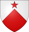
Għargħur [ ɐːˈrɔʊr ] (or Ħal Għargħur ) is one of the oldest and smallest cities in Malta . Għargħur is located on a hill between two valleys in the northeast of the island and has 2857 inhabitants (as of December 31, 2018). His coat of arms consists of a red star and a red triangle on a silver shield with the motto Excelsior . This motto indicates that the city is geographically located on one of the higher points of Malta.
Għargħur was a rural community in an area that did not have particularly fertile soil and where there was constant water shortage. The main attraction of the city is the parish church dedicated to St. Bartholomew is consecrated. The interior has a Doric layout, but the facade was built in the Baroque era . The original facade was destroyed and rebuilt in 1743. The church itself was built between 1610 and 1638 by the Maltese architect Tumas Dingli.
Among their treasures there is also a wooden statue of St. Bartholomew , which was carved in Rome and is attributed to the Maltese artist Melchiore Gafà. It was made around 1666 and is believed to be the model for a similar statue in the Lateran Church in Rome. It was acquired in 1772. It was restored in 1912. In 2005 the statue and its niche were restored again.
The Victoria Lines , named after Queen Victoria , which divide the island from east to west, also run through this place. There are also other fortifications. Most of Malta's telephone infrastructure is located in Għargħur.
Before the installation of the radar systems, there was a concave wall in Għargħur, which was used to locate airplanes flying in from Italy during the Second World War . The residents call this building " il-Widna " (English: the ear). Many refugees were evacuated from the area around the Great Port during the war to G Hafenargħur. They sought protection from the constant bombing of the Axis powers . The public school was used as refugee accommodation.
The main event in the annual cycle is the town festival, which is celebrated on August 24th - or, if it does not fall on a Sunday, on the last Sunday in August. The statue of the saint is carried on shoulders along the illuminated streets and accompanied by music bands. A colorful fireworks display marks the end of the city festival.
There has been a recent debate about the actual name of the city - whether it is Gargur or Ħal-Għargħur . The original name was Ħal-Għargħur. Ħal is an old abbreviation for Raħal (German: village, small town). Għargħur is probably derived from Gregorio , since the city was called Casal Gregorio in the middle of the 15th century . The current debate is possibly due to the influence of the British occupation (1800–1964). It is also possible that the name Gregorio slipped away in the process of Italianization that the Maltese language went through. Similar examples can be found with the names Żurrieq , who appeared in earlier documents as Zurico , and Naxxar , who was called Nascario . The name Għargħur is probably derived from Għargħar , the Maltese national tree .
Web links
Individual evidence
- ↑ StatDB of the National Statistics Office Malta , accessed on August 1, 2020

