Fineil tip
| Fineil tip | ||
|---|---|---|
|
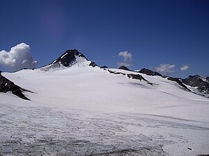
Fineilspitze from the southeast |
||
| height | 3514 m above sea level A. | |
| location | Tyrol , Austria and South Tyrol , Italy | |
| Mountains | Ötztal Alps | |
| Dominance | 4 km → Similaun | |
| Notch height | 504 m ↓ Niederjoch | |
| Coordinates | 46 ° 46 '49 " N , 10 ° 49' 54" E | |
|
|
||
| First ascent | September 8th, 1865 by Franz Senn with guides Cyprian Granbichler and Josef Gstrein | |
| Normal way | Northeast Ridge ( II ) | |
|
Fineilspitze from the north |
||
The Fineilspitze (also written Finailspitze ) is a mountain in the Schnalskamm of the Ötztal Alps on the border between the Austrian state of Tyrol and the Italian province of South Tyrol . The mountain has a height of 3514 m above sea level. A. , or, according to older information, from 3516 m . It sends pronounced ridges to the northeast and southwest. The peak was first climbed on September 8, 1865 by the pastor Franz Senn with the mountain guides Cyprian Granbichler and Josef Gstrein over the northeast ridge from Vent .
Location and surroundings
The Fineilspitze is located in the Schnalskamm, a mountain range that runs mainly from east to west through the southern Ötztal Alps. In the west and north it is surrounded by the Hochjochferner glacier , the nutrient area of which extends almost to the summit. Significant neighboring mountains in the ridge course are in the southeast, separated by the Tisenjoch ( 3208 m , site of the Neolithic glacier mummy Ötzi ) and the Niederjoch ( 3016 m ), the 3599 m high Similaun , and in the west lies the Black Wall with a height of 3355 m . The nearest village in the south is our lady in Schnalstal , about seven kilometers as the crow flies, in the north is Vent , a good 10 km away. The mountain flanks on the South Tyrolean side represent the westernmost extension of the Texel Group Nature Park .
Base and ascent
The first to climb to Franz Senn came from the village of Vent, where Franz Senn was pastor. They climbed from the Hauslabjoch to the summit over the formerly glaciated northeast ridge , which is currently free of ice due to the climate-related glacier melt .
Today's normal route takes the 3019 m high Similaunhütte on the Niederjoch (about 4 hours from the Vernagt reservoir ) as the starting point. From there a marked rock path, secured in places with fixed ropes , leads over to the 3208 m high Tisenjoch, where a slender stone pyramid reminds of the discovery of the glacier mummy " Ötzi ". Now you follow climbing tracks up to the east ridge, orienting yourself towards Steinmandln and via this you reach the highest point bearing a summit cross . The ascent includes several easy climbing points with difficulty level I- and the crossing of firn fields . According to the literature, it takes around 2 hours from the Similaunhütte to the summit.
Another route leads from the notch (3375 m) between Fineilspitze and the Eastern Fineilkopf over the southwest ridge to the summit cross and requires high-altitude touring equipment and glacier experience.
Surname
The Fineilspitze owes its name to the Finailhof , which is located south of the summit in Schnalstal. Its name can be traced back to an Alpine Romanesque fenīle meaning "hay barn".
Literature and map
- Walter Klier : Alpine Club Guide Ötztaler Alpen , Bergverlag Rother, Munich 2006. ISBN 978-3-7633-1123-1
- Hanspaul Menara : The most beautiful 3000m peaks in South Tyrol. 70 worthwhile alpine tours. Athesia, Bozen 2014, ISBN 978-88-8266-911-9
- Alpine Club Map 1: 25,000, sheet 30/2, Ötztal Alps - Weißkugel
Web links
Individual evidence
- ↑ http://www.austrianmap.at BEV 1: 50.0000
- ^ Walter Klier: Alpine Club Guide Ötztal Alps . Bergverlag Rother . Munich 1993. ISBN 3-7633-1116-5
- ↑ Johannes Ortner: Blunt and pointed . In: Experience the mountains - The magazine of the Alpine Association of South Tyrol . No. 4 , 2018, p. 62-63 .


