
Similaun
| Similaun | ||
|---|---|---|
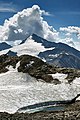
 Similaun from the northwest |
||
| height | 3599 m above sea level A. | |
| location | Border Tyrol , Austria / South Tyrol , Italy | |
| Mountains | Ötztal Alps | |
| Dominance | 2.8 km → Back blackness | |
| Notch height | 250 m ↓ Similaunjoch | |
| Coordinates | 46 ° 45 '49 " N , 10 ° 52' 50" E | |
|
||
| First ascent | 1834 by Josef Raffeiner and Theodor Kaserer | |
| Normal way | High tour from the Similaunhütte via Niederjochferner and Westgrat | |
 Similaun north face in 1981 |
||

The Similaun ( [ ˌsimiˈlaʊ̯n ] ) is a 3599 m (according to the Alpine Club map 3606 m ) high, formerly ice-covered mountain of the Schnalskamm in the Ötztal Alps on the border between the Austrian state of Tyrol and the Italian province of South Tyrol . The first tourist ascent of the Similaun took place in 1834 by the clergyman Theodor Kaserer, led by Josef Raffeiner, from Our Lady in Schnalstal .
Location and surroundings
The mountain is located about four kilometers as the crow flies northeast of the Vernagt reservoir at the upper end of the Schnalstal and eleven kilometers south of Vent , a district of the municipality of Sölden in the Ötztal . The mountain rises geographically dominant over the surrounding glaciers . In the north of the Similaun lies the southern branch of the Marzellferner , in the east and south the Grafferner extends . To the southwest, the mountain falls steeply into a gravel field called Similaungrube . The summit of the Little Similaun (3364 m) sits on its western ridge . Neighboring peaks along the Schnalskamm are in the west beyond the Niederjoch ( 3,016 m ) and Tisenjoch ( 3208 m , site of the Neolithic glacier mummy Ötzi ) the Fineilspitze ( 3,514 m ) and in the northeast, separated by the Similaunjoch ( 3,349 m ), the Western Marzellspitze ( 3529 m ). The South Tyrolean parts of the mountain are protected in the Texel Group Nature Park .
geology
The Ötztal main ridge between Similaun and Karlesspitze is located in a 12 kilometer wide gap between the Vinschgau and Schneeberger slate zone . The main ridge peaks in this area consist of hard, largely weatherproof gneiss on the north side and granite in the south, which means that the summit region of the Similaun protrudes very steeply from the surroundings.
Bases and paths
The route of the first climbers from 1834 ran from the village of Unser Frau im Schnalstal to the south over the Kasererwartl and Grafferner summits to the Similaungipfel.
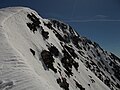
The Similaunhütte , located to the west-north-west, at 3019 m above sea level on the Niederjoch, serves as a base for ascent of the Similaun . From the hut, the normal route leads as an alpine tour with appropriate equipment in a south-easterly direction over the flat firn of the upper Niederjochferner and over the snow-covered west ridge to the summit in about two hours, according to literature. The Similaungipfel can also be reached in four hours from the Martin-Busch-Hütte ( 2501 m ). The path (high tour) leads south over the orographic left edge of the Niederjochferner to the western ridge of the Similaun. The Similaun is also a popular ski peak. The ice tour through the north face , which was first undertaken in 1907 and is regarded as a classic , has been completely dried out in the lower area due to the melting of the glaciers ; Because of the risk of falling rocks , the routes through the north face are no longer used.
Surname
The etymological interpretation of the name Similaun , which was already documented in the 15th century, is unclear. The final emphasis on -aun indicates an Alpine Romanesque origin. This could be a combination of the word summa ("highest point, hill") with the typical Alpine Romanesque suffix ōne or the name summalōne with the meaning "highest points of an area" as the origin.
Literature and map
- Walter Klier , Alpine Club Leader Ötztaler Alpen , Munich 2006, ISBN 3-7633-1123-8
- Hanspaul Menara : The most beautiful 3000m peaks in South Tyrol. 70 worthwhile alpine tours. Athesia, Bozen 2014, ISBN 978-88-8266-911-9
- Raimund von Klebelsberg , Geology of Tyrol , Berlin 1935
- Alpine Club Map 1: 25,000, sheet 30/1, Ötztal Alps, Gurgl
- Tabacco-Verlag , Tavagnacco, Carta topografica 1: 25.000, sheet 04, Val Senales / Schnalstal
Illustrations

View of the Similaun from the east
Similaun from the west

Similaun vom Niederjoch (2018), large parts of the normal route over the Niederjochferner can be seen
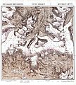
Special map of the Eastern Alps Section Similaun, 1874

Similaun and Kleiner Similaun from Vorderen Brochkogel , Kreuzspitze in front of it on the left
The falls of the Similaun to the southwest into the Similaun pit

View down to the Vernagt reservoir

.jpg)
.jpg)


Web links
Individual evidence
- ↑ ÖK50
- ^ Raimund von Klebelsberg : Geologie von Tirol , Berlin 1935, p. 166
- ^ Journal of the German and Austrian Alpine Club , Volume VII, Munich 1876, p. 222
- ^ Walter Klier: Alpine Club Guide Ötztaler Alpen , Munich 2006, p. 392 ff.
- ↑ Johannes Ortner: Blunt and pointed . In: Experience the mountains - The magazine of the Alpine Association of South Tyrol . No. 4 , 2018, p. 62-63 .