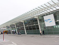
Grenoble airport
| Aéroport Grenoble-Isère |
|
|---|---|

|
|
| Characteristics | |
| ICAO code | LFLS |
| IATA code | GNB |
| Coordinates | |
| Height above MSL | 397 m (1302 ft ) |
| Transport links | |
| Distance from the city center | 40 km northwest of Grenoble |
| Street | A48, D119 |
| Basic data | |
| opening | 1968 |
| operator | SEAG ( Keolis - Vinci ) |
| Terminals | 3 |
| Passengers | 308,012 (2019) |
| Flight movements |
3,825 (2019) |
| Runways | |
| 09/27 | 3050 m × 45 m asphalt |
| 09R / 27L | 900 m × 50 m grass |
The Grenoble Airport (. French Aéroport Grenoble-Isère , IATA code : GNB , ICAO : LFLS ) is an airport in the French department of Isère . It is located about 40 km northwest of the city of Grenoble in the municipality of Saint-Étienne-de-Saint-Geoirs .
It was opened in 1968 shortly before the 10th Winter Olympic Games and replaced the old Grenoble-Mermoz airport, on the site of which the Olympic Village was built. The airport is mainly approached by charter airlines, the main travel time is the winter season in the surrounding winter sports areas.
Airlines and Destinations
The vast majority of scheduled connections are to Great Britain and are operated by Ryanair and Easyjet .
See also
Web links
- Website of the Aéroport Grenoble-Isère (English / French)
Individual evidence
- ↑ a b Bulletin statistiquetrafic aérien commercial - Année 2019. In: ecologique-solidaire.gouv.fr. Ministère de la Transition écologique et solidaire, accessed on May 27, 2020 (French).
- ^ AIP France . S. AD-2.LFLS-4 ( PDF file with p. AD-2.LFLS-4 (222 KiB) [accessed December 22, 2014] last corrections: AIP amendment 01/2015, AIP AIRAC amendment 13/2014 (both in force from December 11, 2014)).
