Haarhausen (Wachsenburg Office)
|
Haarhausen
Municipality of Wachsenburg
Coordinates: 50 ° 51 ′ 45 ″ N , 10 ° 53 ′ 50 ″ E
|
|
|---|---|
| Height : | 264 m above sea level NHN |
| Residents : | 532 (Jun 15, 2009) |
| Incorporation : | June 30, 1994 |
| Incorporated into: | Wachsenburg community |
| Postal code : | 99334 |
| Area code : | 03628 |
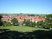
Haarhausen is a village in the municipality of Wachsenburg in the Ilm district , on the Neudietendorf – Arnstadt railway line and five kilometers from the 4 federal motorway . It has about 550 inhabitants.
Geography and geology
Haarhausen is at the transition from the Thuringian Forest to the Thuringian Basin at an altitude of about 275 m above sea level. NN .
While the terrain north of the village is flat, the west-south edge is bounded by a chain of hills (Rückberg at 329 m above sea level, Ziegenberg at 333 m above sea level and Kalkberg at around 300 m above sea level), which is part of the so-called Eichenberg – Gotha – Saalfelder fault zone , which was created by the breaking off of the plaice of the Thuringian Basin during the uplift of today's Thuringian Forest in the Tertiary . On the road (Kreisstraße K 24) to Holzhausen , the associated rock faults are clearly visible and documented in a former quarry. This quarry was granted the status of a natural monument ("FND Schottergrube") in 1959 and is part of the Drei Gleichen Geopark .
The village is traversed from south to north by the Vasold brook (rises in a pond west of Holzhausen), which joins the Roßbach north of the sports field with the Roßbach, which rises south of the locality, and drains over the mud ditch and the Weidbach into the Apfelstädt .
history
The name of the place is derived from the Old High German hora (= swamp ), which refers to the damp lowlands north of today's village. At the beginning of the 9th century, Haarhausen was first mentioned in a document as Horhusun in the Breviarium sancti Lulli of the goods lent by Archbishop Lullus († 786) of Mainz for the monastery of Hersfeld von Free . However, earlier settlements from the 4th or 5th century can be found in the area. This is the result of excavations carried out in the 1980s. The historical underground was researched in a three-year excavation campaign, which made important contributions to the hypothesis of a Roman settlement on free-Germanic soil in the 3rd century. As a result of these excavations, the Weimar Museum for Prehistory and Early History of Thuringia built a site for experimental archeology and a pottery museum on the western edge of the village , the main exhibit of which is a reconstructed Germanic kiln for ceramics (see also: History of Thuringia ).
In 1450 Haarhausen belonged to the castle and the Wachsenburg office . In 1451, the nearby Veste Wachsenburg , one of the three equals, was conquered from Haarhausen by the citizens of Erfurt , whose owner at the time, the robber baron Apel von Vitzthum, had the passing merchants robbed.
Like many villages in Germany, Haarhausen was badly affected by the Thirty Years War . After the end of 1648, building activity began. Many of the houses in the old town center date from this time. The village itself was then dominated by agriculture for many centuries, although there were no large estates. There sat the Protestantism by the predominant religion in the village. From 1697 to 1918 the village belonged to the Duchy of Saxony-Gotha , then to the Arnstadt district of the newly created state of Thuringia . At that time about 450 residents lived in Haarhausen. In 1867 Haarhausen received a stop on the Neudietendorf – Ritschenhausen railway line .
A major upheaval for the village was the formation of the LPG in 1960, which meant the end of the individual farms that had been operating up to then and also left clear traces in the appearance of the corridors. In addition, large stables were built on the north-western outskirts, initially as open stables under the influence of Soviet agricultural policy . The LPG was restructured in the 1970s and 1980s together with those of the neighboring villages as LPG plant production and LPG animal production . Today's legal successor is the Thörey agricultural cooperative .
In 1972 two passenger trains collided near the station. Three people died in this train accident.
After reunification , building activity began on the northern edge of the village, and the Zur Aue residential area was created , where mainly residents of the nearby towns built their homes on the green meadow .
In the course of the municipality reform in Thuringia, the village lost its status of an independent municipality in 1994 and became one of five districts of the Wachsenburg municipality alongside Holzhausen , Sülzenbrücken , Röhrensee and Bittstädt . With the dissolution of the municipality on December 31, 2012, the place came to the municipality of Wachsenburg .
Attractions
St. Nicholas Church
Community hall
The community hall, which was restored in the year 2000, is attached to the community restaurant, with its medallion portraits of Goethe , Schiller , Beethoven and Wagner, among others , as well as other decorations.
Others
- The place is on Otto-Knöpfer -Weg.
- On the already mentioned Ziegenberg in the south of the village, an area has been declared a "surface natural monument on the Weihersberg".
Club life
Club life is shaped by the volunteer fire brigade and the SG Wachsenburg Haarhausen eV sports club . This club was founded in 1984 and offers a wide variety of sports such as football, darts, gymnastics and bowling. Due to its large youth area, football is the largest section in the club. The sports club is the club with the largest number of members in town. The Haarhausen Carnevals Association was founded in 1970 and with over 120 members is one of the largest associations in Haarhausen.
traffic
Haarhausen is on the K 24 district road from Holzhausen to Apfelstädt . The next connection points to the A 4 federal motorway are Neudietendorf and Wandersleben .
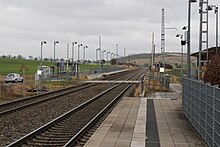
Haarhausen has a stop on the Neudietendorf – Arnstadt railway line to the east of the village , which is served every hour by regional trains of the Erfurt Railway and South Thuringia Railway . These travel to Neudietendorf and Erfurt in the north and to Arnstadt in the south, where the trains are separated. The front part of the train goes to Saalfeld , the rear part to Ilmenau .
Personalities
- The writer Martin Stade (1931–2018) was born in Haarhausen and grew up there. Many of his books are about his Thuringian homeland.
- The animal painter Arthur Heyer (1872–1931), who later emigrated to Hungary, was born here.
literature
- Marko Schubert: Haarhausen. St. Nicholas village church . In: Mathias Werner (ed.): Romanesque ways around Arnstadt and Gotha , a joint project of the juvenile detention center Ichtershausen and the Friedrich Schiller University Jena . VDG - publishing house and database for the humanities, Weimar 2007, ISBN 978-3-89739-549-7 , pp. 147–151.
- Sigrid Dušek : Haarhausen, part: 1: Reconstruction of a pottery kiln and the firing process (= Weimar monographs on prehistory and early history , Volume 16), Museum for Prehistory and Early History of Thuringia, Weimar 1986 DNB 880742798 .
Web links
Individual evidence
- ^ Website of the municipality


