Taranto harbor
| Taranto harbor | |||
|---|---|---|---|
| Data | |||
| UN / LOCODE | IT TAR | ||
| operator | Taranto Port Authority ( ADSP del Mar Ionio ) |
||
| opening | antiquity | ||
| Port type | seaport | ||
| Throughput | 24,668,850 t (2016) | ||
| website | www.port.taranto.it | ||
| Geographic information | |||
| place | Tarent | ||
| region | Apulia | ||
| Country | Italy | ||
|
Taranto from the north: industrial port on the right in the picture (Mar Piccolo with naval arsenal in the middle) |
|||
| Coordinates | 40 ° 28 ′ 32 " N , 17 ° 10 ′ 28" E | ||
|
|||
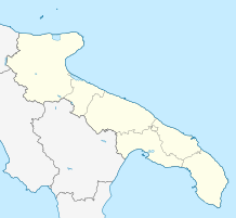
The port of Taranto ( Italian Porto di Taranto ) is an Italian seaport in Apulia . It is located on the Ionian Sea , in the north of the Gulf of Taranto , immediately west of the city of Taranto . From this commercial and industrial port, the east adjoining marina Taranto and the naval base Taranto are to be distinguished. There have been port facilities in Taranto since antiquity , construction of the modern industrial port began in 1968.
Location and history
Taranto, the city of two seas , is located on one as Mar Piccolo designated lagoon , which consists of two circular parts. The roadstead by the open sea is called Mar Grande . The lagoon is separated from the roadstead by an island, the Isola del Borgo Antico . In the north the island is connected to the mainland by the bridge Ponte di Porta Napoli , in the south by the swing bridge Ponte Girevole . Until the construction of the naval base and the arsenal in Mar Piccolo in the 1880s, Taranto was a small town that was limited to this island. For centuries, the small commercial port was located at the northwestern end of the island, in the area of Piazza Sant'Eligio , where the Taranto marina is today. It was somewhat protected in the south by the small pier Sant'Eligio .
While considerable funds were invested in the construction of the naval arsenal at the end of the 19th century, the trading port in the northwest was initially neglected. By 1904, a second mole was built opposite the previous trading port from the mainland, which served as a breakwater in the west , but had a quay wall inside the port and thus offered additional berths. It was named San Cataldo . The quays on the mainland, located between the two harbor piers and opposite the main train station in Taranto, were built until 1935. This made the port roughly in the shape of a hexagon, as was common in Roman times .
At the end of the 1950s, the decision was made to build a fourth steel mill complex of national interest in Taranto after Genoa - Cornigliano , Piombino and Naples - Bagnoli . An area northwest of Taranto, close to the train station and the commercial port, with free access to the sea, was chosen for the construction of these very large facilities for the Italsider state company and for a new oil refinery for the Eni group . After the inauguration of the steelworks in 1965, a port development plan for the commercial port was presented in 1967. The plan provided for an expansion of the port to the west. In contrast to the previous commercial port (Porto mercantile) , the new, immediately adjoining area was called the industrial port (Porto industriale) . The previous port of San Cataldo was converted into a 330-meter-long Pier 1 during the first steel crisis , followed by three more piers, each over 500 meters long, in a westerly direction and finally the discharge bridge of the oil port at the refinery. Beyond the pier, which runs from Punta Rondinella to the west, in the direction of the Cheradi Islands , i.e. outside the Mar Grande , a fifth pier and a container terminal were later built.
After further steel crises and becoming unprofitable due to mismanagement, the steelworks were sold in 1995 to the Riva Group , which implemented drastic rationalization measures without reducing the serious environmental impact. Despite these problems, the steelworks complex remained the largest in Europe after the turn of the millennium, with correspondingly positive effects on cargo handling in the port. In 2006, with almost 50 million tons , it was second in Italy after Genoa and before Trieste . With the container terminal opened in 2001 and other measures, attempts were made to diversify the handling of goods and thus to become a little less dependent on the steelworks, but with little success: in 2016 the turnover was almost 24.7 million tons and the operator of the container terminal went into Bankruptcy. Since then, the reformed port authority has been trying to realign and modernize the port and win new customers. At the beginning of 2018, the consortium Southgate Europe Terminal and South Marine Gate applied for concessions for parts of the container terminal.
Infrastructure and use
The the Suez Canal and thus to the shipping routes in the Middle and Far East port relatively convenient location is multimodal very well connected: on the Adriatic highway A14 and the Adriatic Railway to northern Italy and from there to Central Europe, and on state roads ( 7 , 106 ) and regional railway lines with the southern Italian region. The international airports of Bari and Brindisi are around 90 and 75 kilometers away. The Taranto-Grottaglie Airport has a 3,200 meter-long runway is however currently served only by freighter aircraft carrying built in Puglia aircraft components in the United States.
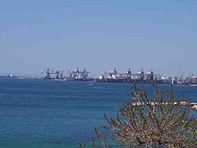
The facilities of the commercial and industrial port extended to around 340 hectares in 2016 , the length of the shore of all quays was a total of almost 10 kilometers. The entrance to the port in Mar Grande is 25 meters deep, the depth of the port basin is between 8 (east) and 16.5 meters (west). The old commercial port is now de facto divided into two parts: the eastern part (Sant'Eligio) is the marina, the western part (San Cataldo) is not only a commercial but also a passenger port. Service and handling facilities have been built on Pier 1 for passenger traffic and visitors. This pier mostly handles general cargo of all kinds, but also solid bulk cargo . Piers 2 and 3 are reserved for the steelworks: raw materials necessary for steel production are mostly unloaded and steel products are loaded there. Pier 4 is shared by the steel plant and the cement plant Cementir Italia . This pier is to be expanded to the west and a so-called logistics platform is to be built behind it. Piers 2, 3 and 4 have a number of harbor cranes and conveyor belt systems that enable material to be transported directly from the harbor to the steel and cement works. The four piers mentioned are followed by a harbor basin with facilities that house state security authorities and port operations centers with associated sea vessels such as patrol boats , pilot boats and tugs . At the northwestern end of the Mar Grande is the oil port with its 560 meter long discharge bridge. In the middle of the Mar Grande there is a buoy field . From there, tankers can pump their cargoes directly to the refinery via an underwater pipeline .
The 1,200-meter-long Pier 5, on the other side of Punta Rondinella and the pier, is also used for embarking steel products. It is connected to the steelworks via track systems and also has several large harbor cranes. This pier is to be expanded in a south-easterly direction to form a platform measuring over 120 hectares. Another pier is planned to be built between this platform and Punta Rondinella . In the far west is the so-called multi-purpose pier, a spur-shaped, 110-hectare platform with a very modern container terminal with an annual capacity of over 2 million TEUs . It has ten container gantries and 23 other porters as well as reach stackers and other heavy vehicles. The track systems there are directly connected to the national track network.
Others
On the island of Borgo Antico there is a small fishing port at Mar Piccolo . There are other small moorings at Mar Piccolo outside of the military restricted areas, especially on the mainland on the bank section near the main train station. In the eastern area of the Mar Grande there are smaller marinas in front of the new town .
Since the opening of the Chiapparo naval base in the east of the Mar Grande in 2004, the space required by the navy in the Mar Piccolo has decreased. For this reason, the Navy has been asked several times to make its so-called torpedo boat harbor available for civil use. It is the south-western section of the bank of the Mar Piccolo , which you can see on the right after passing the southern canal and its swing bridge. From the quays to the small bay where the naval arsenal is located, the navy is to give up about half and the wall that seals off this area from the Villa Peripato green area and the settlements of the new town are to be torn down so that this district can be accessed Mar Piccolo receives. The plans of the port authority envisage a use as a marina and possibly the construction of a cruise terminal .
In 2004, military use by the United States Navy was under discussion for the port facilities to the west of Punta Rondinella and the pier .
Web links
- Website of the port authority (English / Italian)
- Port overview of the port authority (Italian)
- Information on expansion projects
- Description of the port on the website of the Taranto pilotage service
Individual evidence
- ↑ port.taranto.it Taranto 2016 (ital.). Accessed February 12, 2018.
- ↑ Cover overview 2006 on assoporti.it
- ↑ informare.it June 7, 2017
- ↑ Description of the project from future.port.taranto.it
- ↑ Presentation on peacelink.it


