Gauerstadt
|
Gauerstadt
City of Bad Rodach
Coordinates: 50 ° 18 ′ 27 ″ N , 10 ° 48 ′ 14 ″ E
|
|
|---|---|
| Height : | 291 m |
| Area : | 2.74 km² |
| Residents : | 452 (2016) |
| Population density : | 165 inhabitants / km² |
| Incorporation : | May 1, 1978 |
| Postal code : | 96476 |
| Area code : | 09564 |
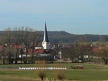
Gauerstadt , since 1978 a district of the Upper Franconian town of Bad Rodach in the district of Coburg on the northeastern edge of the Long Mountains , only three kilometers from the state border Bavaria / Thuringia , in the Rodach valley .
history
Beginnings
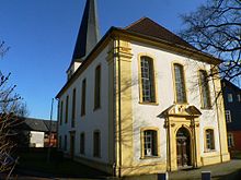
Gauerstadt's history began with the year 838, when the place was mentioned under the name "Gunbrathesstadt" together with other villages founded in the Coburg region in a document deposited in the Fulda monastery . In 1171, the name "Guberstadt" can already be found in a donation from the Bishop of Würzburg . The aim was to transfer the village church to the Mönchröden monastery . Around this fortified church at that time, the houses and courtyards were grouped in four settlement parts, which are still clearly recognizable in the town plan.
The village gained a modest reputation in the high Middle Ages when the noble family von Guberstadt, first mentioned in 1317, settled there. In 1364 Hans von Guberstadt sat at Altenstein Castle, which dominates the Baunach Valley, and around 1434 Apel von Guberstadt became mayor of Schweinfurt . In 1489, the Coburg nobleman Anthony von Rosenau , a descendant of the Coburg mint master dynasty , rose to be Lord of Guberstadt. He was followed by other gentlemen from Rosenau, all of whom found their final resting place in the church of Gauerstadt.
War and strife
The Thirty Years War hit Gauerstadt, as the place was now called, tremendously. At the beginning of the religious war there were still over 350 people living in the village, in 1636 there were only 50, including 10 widows . Of the previous 64 houses and farms, 39 still stood, 24 of which were uninhabited. War, famine, plague and looting had decimated or driven the population away. In the last days of 1636, Swedish soldiers broke into the village, broke into the church, and took everything they could carry with them.
The close border between Saxony-Hildburghausen with the neighboring village of Billmuthausen and Saxony-Coburg with Gauerstadt also gave rise to constant disputes after 1680. Often wood, water and hunting rights have been violated and had before the competent courts in Hildburghausen be clarified and Coburg, as well as disputes arising from the in the 13th century by King Rudolf von Habsburg introduced administrative territories . The Gymnasiumsvogthey in Coburg was based on their legal basis , according to which farmers from Gauerstadt could pledge land to the Gymnasium Casimirianum if they ran into financial difficulties.
In 1726 a dispute broke out between Gauerstadt and Rodach over the right to brew beer, which was finally granted to the Gauerstadt residents by ducal power, as did two controversial fields near Rodach 50 years later. In the same year the duke needed 22,000 guilders and "hypotized" his chamber property in Gauerstadt to the court Jew Seligmann zu Mitwitz .
Towards the end of the 18th century, before the start of the Napoleonic Wars , a "Chursächsisches Infranterieregiment" moved through the Coburg region and took up quarters in Meeder , Großwalbur and Gauerstadt. On January 12, 1795, those obliged to provide accommodation received strict instructions from the "Franconian Crais-General-Quartier-Meister-Amt Nürnberg", soldiers and officers "to serve the cheapest prices". It was made even worse by constant tax increases and billeting from 1813, because on the one hand the duke and thus his subjects bore the French burden of war, on the other hand Napoleon's troops demanded to be accommodated free of charge. After Napoleon's final defeat in 1815, the situation initially improved due to the loss of the burdens of war, but the authorities left no stone unturned in asking the citizens to pay up by introducing more and more taxes.
Tax burdens
In addition to the already existing taxes, there was a meat tax , a drink tax , a beer penny , a wine transport fee, a cow tax, the neighbor money, the protection money and the land protection money until 1870 . If they were members of the North German Confederation , those wishing to move had to pay 50 guilders for men and 25 guilders for women in Gauerstadt , while new residents from outside the Graubünden got away with five guilders as “patrons”.
Simultaneously with this taxation tide sat in the Coburg region the Dismembration a goods mentioned by busting a commercial air dismemberment of larger goods had (called "butcher goods") by entrepreneurs to the goal. They bought land as cheaply as possible in order to sell them on at high profits. Around 1850, three widows from Gauerstadt ran into such financial difficulties that they asked Duke Ernst II of Coburg for permission to sell their goods. The duke, who initially expressed concerns, finally agreed because of the "distressed situation" of the women, especially since the Gauerstadt patrimonial court had already opened bankruptcy proceedings against one of them and the landlord threatened to confiscate their agricultural property. This considerable influence of private jurisdiction ended in 1877 with the introduction of a new civil and criminal procedure code in the German Empire .
Incorporations
In the middle of the 19th century, in addition to the Gauerstädter domain estate with 144 hectares, there was another one in Niederndorf with 58 hectares and in Carlshan with 62 hectares. These two domains were only one and two kilometers from Gauerstadt. In 1870 the neighboring hamlets of Niederndorf and Carlshan lost their independence and were added to Gauerstadt, the population of which increased by around 80 people.
It was only after the First World War that the now expanded Gauerstadt was connected to the electrical power supply (Coburg had already been on the grid for 15 years at this point). In 1920 Gauerstadt, like the entire Coburg region, became part of Bavaria . The district survived the Second World War relatively undestroyed. Before American troops marched in, Gauerstadt was set on fire by fighter bombers on April 10, 1945. 43 farmsteads burned down to their foundations, four were partially badly damaged. The district of Coburg subsequently became part of the American zone of occupation , while the Thuringian hinterland was part of the Soviet zone of occupation . Billmuthausen, whose children always went to school in Gauerstadt, was now on the other side of the zone border , which was finally cordoned off on May 26, 1952. Only a few days before, seven Billmuthaus families with 34 people and all their movable belongings fled across the border to Bavaria. Four families stayed in Gauerstadt.
The Bavarian municipal reform carried out in the 1970s reduced the number of municipalities in the Coburg district from 129 to 51 as of May 1, 1978. Gauerstadt including the wasteland Neumühle, 0.4 kilometers east of Gauerstadt an der Rodach ⊙ , and Hainmühle, 1 , 2 kilometers north of Gauerstadt an der Rodach ⊙ , and the hamlet of Niederndorf and Carlshan was incorporated into Rodach near Coburg that day. Gauerstadt's last mayor, Walter Müller, became a city councilor in the new large community.
economy
One of the oldest inns in the Coburg region is the community inn in the center of the village opposite the parish church of Gauerstadt, first mentioned in 1523, which has been family-owned since 1863 and is now run as a country inn with a hotel. The Büchner brewery, which belonged to the inn, existed from 1863 to 1985, which from 1950, taken over by the son-in-law, was called the Wacker brewery and had brew pans that were visible from the street . There was also a cooperative brewery, which was founded in 1875 and closed in 1960, and the Gaudlitz brewery in the second half of the 19th century.
traffic
Gauerstadt is three kilometers from the Bavarian state road No. 2205, which connects Coburg with Bad Rodach and Hildburghausen . A district road that branches off from it at Großwalbur also leads via Gauerstadt to Bad Rodach.
The railway line between Bad Rodach and Coburg is traveled by closure plans in the 1980s again regularly every hour. The closest stations to Gauerstadt are Großwalbur and Bad Rodach, both four kilometers away.
There is also an OVF bus line from Coburg via Gauerstadt to Bad Rodach and Hildburghausen (8313) and another from Großwalbur via Gauerstadt to Bad Rodach (8315).
swell
- City administration Rodach
- Coburger Tageblatt special edition 1983
- Heimatverein Rodach
Individual evidence
- ↑ Irmhild Tschischka: Scrolled through the chronicle of the Bad Rodach districts; A piece of Bad Rodach's city history . P. 71
- ↑ Irmhild Tschischka: Scrolled through the chronicle of the Bad Rodach districts; A piece of Bad Rodach's city history . Writings of the Rückertkreis Bad Rodach eV, issue 29, Bad Rodach 2005, ISBN 978-3-943009-29-3 , p. 42
- ^ Federal Statistical Office (ed.): Historical municipality directory for the Federal Republic of Germany. Name, border and key number changes in municipalities, counties and administrative districts from May 27, 1970 to December 31, 1982 . W. Kohlhammer GmbH, Stuttgart and Mainz 1983, ISBN 3-17-003263-1 , p. 680 .
- ^ Wolfgang Vatke: Coburg breweries city and country . Veste-Verlag Roßteutscher, Coburg 2008, ISBN 978-3-925431-03-6 , p. 157


