
Hangzhou Metro

| Basic data | |
| Country | People's Republic of China |
|---|---|
| city | Hangzhou |
| opening | 2012 |
| Lines | 5 |
| Route length | 209 km |
| Stations | 133 |
| Long-distance train stations | 3 |
| use | |
| Shortest cycle | 2 minutes |
| Passengers | 340 million per year (estimated for 2017) |
| vehicles | CSR series B |
| operator |
Joint venture of Hangzhou Metro Group and MTR Corporation (Hangzhou) |
| Gauge | 1435 mm |
| Power system | 1500 V direct current, contact wire |
The Hangzhou Metro ( Chinese 杭州 地铁 , Pinyin Hángzhōu Dìtiě ) is the subway network of the city of Hangzhou and the surrounding suburbs in the Chinese province of Zhejiang . Construction began in March 2007, the first 48 km long line with 31 stations was opened on November 24, 2012, and four more lines have been opened to date. The long-term plan envisages a 375 km network with 13 lines by 2050.
history
With a population of 8.8 million (2013), Hangzhou is one of the ten largest cities in China. The planning of the subway network began in the 1990s. Construction work on this first project was scheduled to begin in September 2003, but was stopped by the city government due to cost overruns.
In 2005, a new attempt was made to plan the underground network, which is to be built in three phases: lines 1 and 2 and part of line 4 were built first, lines 1 and 4 and three should be completed by 2020 more lines will be built; another three lines are to follow by 2050.
The preliminary project for Line 1 was approved by the city government two years later on January 11, 2007, and work on the first line began on March 28, 2007.
In November 2012, Line 1 was the first line in the network to go into operation, making Hangzhou the 17th city in China with a subway. The line is also the longest first section of a new subway system ever opened in China. The construction cost was 22 billion renminbi , which corresponds to approximately 3.5 billion US dollars.
On April 23, 2020, further parts of line 5 and the new line 16 opened after the first part of line 5 opened in June 2019.
network
As of April 23, 2020
| line | Terminals | Opened | Last extension |
Total length in km |
Number of stations |
operator | |
|---|---|---|---|---|---|---|---|
| 1 | Xianghu ( Chinese 湘湖 ) | Xiashajiangbin ( Chinese 下沙 江滨 ) | 2012 | 2015 | 53.62 | 34 | Hangzhou MRT |
| Linping ( Chinese 临平 ) | |||||||
| 2 | Liangzhu ( Chinese 良渚 ) | Chaoyang ( Chinese 朝阳 ) | 2013 | 2017 | 43.32 | 33 | Hangzhou Metro |
| 4th | Pengbu ( Chinese 彭 埠 ) | Puyan ( Chinese 浦沿 ) | 2015 | 2018 | 20.81 | 18th | Hangzhou Metro |
| 5 | Jinxing ( Chinese 金星 ) | Guniangqiao ( Chinese 姑娘 桥 ) | 2019 | 2020 | 56.21 | 37 | Hangzhou MTR |
| 16 | Lvting Road ( Chinese 绿 汀 路 ) | Jiuzhou Street ( Chinese 九州 街 ) | 2020 | - | 35.12 | 12 | Hangzhou Metro |
Lines
In operation
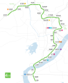
line 1

The line is 47.97 km long, of which 41.36 km run underground, 6.14 km run on elevated railway line and 0.47 km at street level. The line serves 31 stations. It runs from Xianghu in the south of the city under the Qiantang River to the train station and along the West Lake to Wulin Square in the city center, from there it crosses under the Imperial Canal and runs east to the East Railway Station and the Jiubao Bus Station . Here it divides into two branches - one leads north to Linping and the other east to the terminus Wenze Road.
The line, which opened on November 24, 2012, will be operated for the next 25 years by a public-private partnership (PPP). It consists of a joint venture between the local Hangzhou Metro Group and the MTR Corporation from Hong Kong , with MTR Corporation owning 49% of the shares and Hangzhou Metro Group 51% of the shares.
The line is served by 48 series B six-car trains from CSR Nanjing Puzhen , which run every ten minutes during the day. The line is expected to be used by 78 million passengers annually.
During the construction of the line on November 15, 2008, a 75-meter section of the tunnel near Fengqing Avenue in Xiaoshan collapsed, killing 21 workers and injuring another 24.
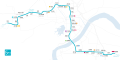
Line 2
The 49 km long line 2 will run from Langzhu in the west through the districts of Xihu , Shangcheng and Jianggan to the east and will cross under the Qiantang River. In the city center, you can change to line 1 at Fengqi Road station, and to line 4 on Qianjiang Road on the same platform opposite.
The construction of the line was divided into two phases. In the first phase, construction began in 2011 on a 33.69 km long section with 26 stations, which in turn is divided into two sections. The 18.66 km south-east section from Zhaoyangcun to Qianjianglu on the north bank of the Qiantang River was opened in 2013, the 15.03 km north-west section from Qianjiang Road to Gucui Road followed in 2017.
For the operation of the line, 27 trains of the B series were ordered from CSR Nanjing Puzhen, which were delivered between 2013 and 2016. The CBTC signal system was supplied by Ansaldo .
This line is currently being expanded further west.
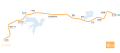
Line 4
The first part of Line 4 begins in Pengbu, runs through Xintang Road and Fuchunjiang Road, passes under the Imperial Canal and will end in Qianjiang New City in the northwest of the city. This section will be 15 km long.
The southern section of the first part was released on February 2, 2015 for test operations with passengers.
The now opened section from Pengbu Station to Jinjiang Station has a length of 9.65 km, with 10 stations, with Xintang station to be opened later. You can change to Line 1 at the three stations Jinjiang, East Station (Dong) and Peng Port. At Qianjiang Road station you can change to Line 2 on the same platform opposite.
The second part of Line 4, to be built later, will lead south from Penbu, cross under the Imperial Canal, then run along the north bank of the Qiantang River, before crossing under it in the west of the city and ending at the Oriental Culture Park.
Line 5
Line 5, 30 miles long, will run west to east, connecting Yuhang and Cangqian Town with the city center. From there it will run south to the train station, cross under the Qiantang River and end at the South Train Station in the Xiaoshan district .
Planned or under construction
Line 3
Line 3, 35 km long, will pass through the northwestern boroughs of Gongshu , Xihu and Shangcheng. It will follow Tianmushan Road, serving the western bus station. In the city center, the line at Wulin-Platz will be combined with Line 1 and together with it will cross under the Kaiserkanal. North of the Imperial Canal, the two lines separate again and line 3 will lead to Dingqiao.
Line 6
Line 6 will be 25 km long. It will connect the industrial areas on the south bank of the Qiantang River and connect them to Lines 1, 2 and 5.
Line 7
Line 7 will be 31 km long and connect Wushan Square north of the Qiantang River with Hangzhou-Xiaoshan Airport south of the river, also opening up industrial areas. The line will have a transfer station with lines 2.
Line 8
Line 8 will be 18 km long, connecting Jiangdong with the Xiasha district. It will be connected to the northern branch of Line 1 at South Qiaosi station.
Line 9
Line 9 will be a short link between a stop on Line 7 and Jiubao Bus Terminal, and will run parallel to the north bank of the Qiantang River.
Line 10
Line 10 will run north from Huanglong Sports Center, where it will split into two branches north of Line 4.
cards

line 1

Line 2

Line 3 (planned)
Line 4
Line 5

Line 6 (planned)

Line 7 (planned)

Line 8 (planned)

Line 9 (planned, section already in operation as a branch of line 1)

Line 10 (planned)
Line 16


See also
Web links
- Hangzhou Metro. Retrieved June 22, 2013 (Hangzhou Metro Official Website).
- Hangzhou Metro. In: Urbanrail. Retrieved June 22, 2013 .
Individual evidence
- ↑ a b c d e f g h i j Hangzhou Metro, Zhejiang. railway-technology.com, accessed June 22, 2013 .
- ↑ 记者 潘婷婷: 杭州 地铁 5 号 线 后 通 段 、 16 号 线 计划 4 月底 通车. Hangzhou.com.cn, March 27, 2020, accessed April 23, 2020 (Chinese).
- ↑ a b c Trial operation on the first section of Metro Line 4 section, from February 2nd. (No longer available online.) Hangzhou.gov.cn, February 2, 2015, archived from the original on February 4, 2015 ; Retrieved February 4, 2015 (Chinese). Info: The archive link was inserted automatically and has not yet been checked. Please check the original and archive link according to the instructions and then remove this notice.
- ↑ a b c d e f g h Hangzhou Subway Map. In: Travel China Guide. Retrieved June 22, 2013 .