Heimburg
|
Heimburg
City of Blankenburg (Harz)
|
|
|---|---|
| Coordinates: 51 ° 49 ′ 20 ″ N , 10 ° 54 ′ 40 ″ E | |
| Height : | 229 m |
| Area : | 19.62 km² |
| Residents : | 859 (Feb. 15, 2018) |
| Population density : | 44 inhabitants / km² |
| Incorporation : | January 1, 2010 |
| Postal code : | 38889 |
| Area code : | 03944 |
|
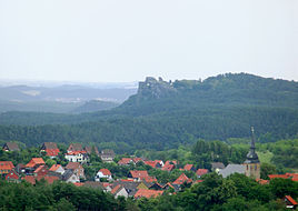
Heimburg seen from the ridge of the Ziegenberg , in the background Regenstein Castle
|
|
Heimburg is a district of the town of Blankenburg (Harz) in the Harz district in Saxony-Anhalt .
Geographical location
Heimburg is located on the north Harz , about 5 km northwest of the core town of Blankenburg (Harz) on the old route of the federal highway 6 in the direction of Wernigerode .
Immediately north of the village is a hill on which the remains of the former Heimburg Castle , also called Altenburg , and a lookout point are located. Heimburg is also located at the foot of the Ziegenberg ( 315.7 m ) and Struvenberg ( 305.7 m ) range of hills , which stretches towards the northwest to Benzingerode , offers a good view of the Harz foreland and is taken in by the Ziegenberg nature reserve near Heimburg .
history
Heimburg was first mentioned in 1073, the Hörigensiedlung at its foot in 1256. After the loss of a feud between Heimburg and Regenstein that lasted several generations , the Counts of Regenstein took over Heimburg Castle. One line of these counts was then called von Regenstein-Heimburg. In the 16th century the castle was pledged several times and after being destroyed in the Thirty Years' War there were no more renovations, so that the castle completely fell into disrepair and was used as a quarry for building materials. After the Regenstein family died out in 1599, the fiefdom reverted to their liege lord, the Duke of Braunschweig.
Heimburg was occupied by US troops on April 20, 1945 after an attack by fighter bombers . At the beginning of July 1945 it became part of the Soviet Occupation Zone (SBZ) and from 1949 the GDR .
During the GDR era, a children's holiday camp was built in the village .
Heimburg belonged to the Brunswick district of Blankenburg until 1945 and in 1952 came to the district of Wernigerode in the district of Magdeburg . Since the district reform came into effect on July 1, 2007, Heimburg has belonged to the Harz district.
On January 1, 2010, the previously independent community of Heimburg was incorporated into the city of Blankenburg (Harz) together with the communities of Cattenstedt , Hüttenrode , Wienrode and Timmenrode as well as the city of Derenburg .
coat of arms
The coat of arms was approved on October 15, 1993 by the Magdeburg Regional Council.
Blazon : “At an angle to the left, silver over gold; above a red deer pole, below three red bars. "
The stag bar represents the affiliation of the place to the County of Regenstein since the 13th century, the lower part of the coat of arms symbolizes the colors of the family coat of arms of those of Heimburg .
traffic
There are bus connections with the Harz transport company in the surrounding towns and a well-developed road network. To the east of the village there is a driveway to the federal motorway 36 and the junction of a connecting road to Derenburg . In the village, a road leads south past the Michaelstein monastery to the Blankenburg district of Oesig .
Attractions
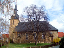
- Holy Trinity Church
literature
- Georg Bode : The Heimburg am Harz and their first family, the Lords of Heimburg , Wernigerode 1909
- Berent Schwineköper (Hrsg.): Handbook of the historical sites of Germany . Volume 11: Province of Saxony Anhalt (= Kröner's pocket edition . Volume 314). 2nd, revised and expanded edition. Kröner, Stuttgart 1987, ISBN 3-520-31402-9 , pp. 204-205.


