Treysa-Ziegenhain flood retention basin
| Treysa-Ziegenhain flood retention basin | |||||||||
|---|---|---|---|---|---|---|---|---|---|
| Outlet structure | |||||||||
|
|||||||||
|
|
|||||||||
| Coordinates | 50 ° 54 '50 " N , 9 ° 11' 46" E | ||||||||
| Data on the structure | |||||||||
| Lock type: | Earthfill dam | ||||||||
| Construction time: | 1967-1972 | ||||||||
| Height of the barrier structure : | 8 m | ||||||||
| Crown length: | approx. 10 km, main dam: 1780 m | ||||||||
| Operator: | Schwalm water association | ||||||||
| Data on the reservoir | |||||||||
| Storage space | 8 million m³ | ||||||||
| Catchment area | 548 km² | ||||||||
The flood retention basin Treysa-Ziegenhain of the Schwalm water association is a flood retention basin (HRB) on the Eder tributary Schwalm near Loshausen , Ziegenhain and Treysa in the north Hessian Schwalm-Eder district and belongs to the catchment area of the Fulda .
As a "green pool", usually located where no water, it serves the flood protection of the pelvis (as Ziegenhain and Treysa ) and below it nearby towns and dortiger infrastructure and protecting the river basin of the Fulda before flood .
Geographical location
The basin is located in the Schwalm landscape , below the confluence of the Steina and Schwalm, on the Schwalm and its tributary Grenzebach . It ranges from Willing Hausener Gemeindeteil Loshausen to the Schwalmstadt districts Ziegenhain and Treysa. Its main dam is almost 500 m east-northeast of the Treysa town center.
history
Because the Schwalm often led strong floods, like the highest recorded Schwalm flood on December 5, 1960 (discharge of 157 m³ / s in Uttershausen ), and flooded large parts of the current basin and the villages downstream, on December 6, 1962 the Schwalm water association was founded, and several flood retention basins were built on the river in the period that followed. This is how the HRB Treysa-Ziegenhain was created on the middle reaches, which absorbs excess swallow water. Construction of its dams began in 1967 and was completed in 1972.
The strongest flood since the dam was built began on 24/25. January 1995, triggered by continuous rain and snowmelt, with the levels falling from February 2, 1995 and the dams of the basin proved their worth.
Dams with outlet structure
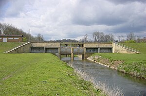
The dams are about 10 km long in total. They consist of earth fills. An outlet structure made of reinforced concrete was integrated into the 1780 m long main dam . Directly south-south-west of the outlet structure, an operating building with control devices was built.
The flood relief ( siphon weir ) works on the principle of the siphon . There are two shafts with large rectangular inlets on each side of the barrier structure. They pull the water out of the basin like a siphon as soon as the water level exceeds the overflow edge, which is located inside the shafts.
Flood retention basin
The dam has 8 million cubic meters of total and flood control room . The storage space is designed for a rainfall or catchment area of around 548 km² , which makes up around 42% of the Schwalm catchment area.
The detention basin consists of two parts: the southeastern upper reservoir formed between Loshausen , Steina and goats grove on the Hohenwiese or Hohwiese lies and no additional shut-off has or outlet structure, and northwestern lower reservoir, which is located between Ziegenhain, Ascherode and Treysa on the floodplain extends. Both basins are connected by the canalised Schwalm. The difference in height (measured on the basin floor) between the upper basin (mean: 212 m height) and the lower basin (mean: 210 m height) is only small.
Work on rivers and infrastructure
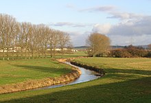
When the main dam was built, the section of the Schwalm watercourse in the dam area was designed as an open canal leading through the dam. In addition, access roads to the dam and a walking, hiking and control path leading over the dam were created.
traffic
The federal road 454 , which shares a section of road with the federal road 254 to the northeast of the upper basin, leads past both basins to the north . The Main-Weser-Bahn runs west past the main dam of the (lower) basin , from which other routes used to branch off near the basin. The Schwalmstadt glider airfield is located on the northern edge of the upper part of the basin .
Individual evidence
- ↑ a b c d e f g h i systems ( memento from December 11, 2013 in the Internet Archive ) of the Schwalm water association, including HRB Treysa-Ziegenhain, on wasserverband-schwalm.de
- ↑ a b HRB Treysa-Ziegenhain, Hessen , on talsperren.net
- ↑ a b Profile: Schwalm , on wasserverband-schwalm.de
- ↑ a b article When the water overflowed , from January 10, 2011, on hna.de.
- ↑ a b Map services of the Federal Agency for Nature Conservation ( information )


