Grenzebach (Schwalm)
| Grenzebach | ||
|
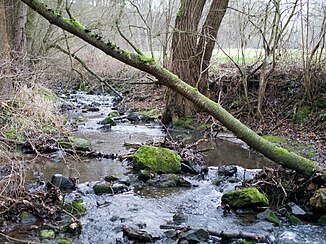
The Grenzebach between the Upper and Lower Limits Bach at the height of the Wichtelloch |
||
| Data | ||
| Water code | DE : 4288334 | |
| location | Osthessisches Bergland , Schwalm-Eder-Kreis , Hesse , Germany | |
| River system | Weser | |
| Drain over | Schwalm → Eder → Fulda → Weser → North Sea | |
| source | near Seigertshausen in the Knüll Mountains 50 ° 55 ′ 14 ″ N , 9 ° 23 ′ 31 ″ E |
|
| Source height | approx. 508 m above sea level NN | |
| muzzle | at Ziegenhain in the Schwalm Coordinates: 50 ° 54 '37 " N , 9 ° 14' 44" E 50 ° 54 '37 " N , 9 ° 14' 44" E |
|
| Mouth height | approx. 210 m above sea level NN | |
| Height difference | approx. 298 m | |
| Bottom slope | approx. 22 ‰ | |
| length | 13.3 km | |
| Catchment area | 18.945 km² | |
| Drain |
MQ |
135 m³ / s |
| Left tributaries | small ditches and rivulets | |
| Right tributaries | small ditches and rivulets | |
|
The Grenzebach on the Schützenwaldweg in Nieder Grenzebach |
||
The Grenzebach is an approximately 13.3 km long, right-hand or northeastern tributary of the Schwalm in the East Hessian Bergland in the north Hessian Schwalm-Eder district and belongs to the river system and catchment area of the Weser .
Course and catchment area
The Grenzebach rises in the East Hessian mountainous region in the Knüll Mountains . Its source is in the Hochknüll about 2.5 km northeast of the Neukirchen district of Seigertshausen , about 2.1 km west-northwest of the Knüllköpfchen ( 633.8 m above sea level ) or about 500 m south of the Bärberg ( 554.2 m above sea level ) at about 508 m above sea level NN .
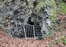
Initially, the Grenzebach, which runs mainly in the direction of the west-south-west, flows south-west through the Knüllgebirge, where it runs a little below its origin through the Neukirchen village of Seigertshausen. It then flows westwards along the state road 3155 to and through the Frielendorfer village of Oberlimitebach , and then to the southwest along the county road 126 to and through the Schwalmstadt village of Niederlimitebach . The Grenzebach has created a steep impact slope in a tertiary lava flow between the Oberbegrenzebach and the Ruch-Mühle . Inside is the Wichtelsloch, a cave. This is originally a gap in the lava flow created by a strain. At the exit of Nieder Grenzebach in the direction of Schönborn , the Grenzebach valley is shaped like a gorge. This is due to the crossing of another tertiary lava flow, which flowed from the boiler, east of Niederlimitebach, towards the northwest. After this, the stream is bridged by the federal highway 454 , among other things .
Then the Grenzebach runs immediately southeast of the Schwalmstadt district of Ziegenhain , after crossing a small canal and after overcoming an altitude difference of around 298 m to around 210 m above sea level. NN on the Hohwiese to flow into the Eder tributary Schwalm , which comes from the southeast and kinks to the southwest .
The catchment area of the Grenzbach covers 18.945 km².
Web links
Individual evidence
- ↑ a b c d Map services of the Federal Agency for Nature Conservation ( information )
- ↑ a b c d e Water map service of the Hessian Ministry for the Environment, Climate Protection, Agriculture and Consumer Protection ( information )
- ↑ JH Schwalm : Excavations in the Wichtelsloch near Ober Grenzebach. Schulchronik Oberbegrenzebach 1933. Reprinted in: Schwälmer Heimatbund eV (Ed.): Schwälmer Jahrbuch 2007, pp. 154–156
- ↑ F. Schmidt-Döhl : The Hessian Bergland - The emergence of a landscape . Shaker Media, Aachen 2012, ISBN 978-3-86858-891-0 .
- ↑ M. Blanckenhorn : Explanations of the geological map of Prussia and neighboring German countries, delivery 261, sheet Ziegenhain, grading department 68, sheet 6 . Berlin, Prussian Geological State Institute, 1926


