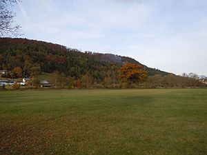
Horber Neckar slopes
|
FFH area
"Horber Neckar slopes" |
||
|
Neckar valley slope southwest of Horb |
||
| location | Freudenstadt district and Rottweil district , Baden-Württemberg , Germany | |
| Identifier | DE-7517-341 | |
| WDPA ID | 555521947 | |
| Natura 2000 ID | DE7517341 | |
| FFH area | 8.106 km² | |
| Geographical location | 48 ° 26 ' N , 8 ° 38' E | |
|
|
||
| Setup date | January 1, 2005 | |
| administration | Karlsruhe Regional Council | |
The FFH area Horber Neckarhangs is a protected area (protected area identifier DE-7517-341) in Baden-Württemberg registered in 2005 by the Karlsruhe regional council according to Directive 92/43 / EEC (Fauna-Flora-Habitat Directive) . With the ordinance of the regional council of Karlsruhe on the definition of areas of community importance of October 12, 2018, the protected area was established.
location
The 810.6 hectare protected area belongs to the nature area 122 - Obere Gäue . It mainly comprises the slopes and floodplains of the Neckar and its side valleys near Horb. The area extends over the boundaries of five cities and municipalities in the districts of Freudenstadt and Rottweil :
- Receiving : 3.08 ha = 0.4%
- Eutingen im Gäu : 12.03 ha = 1.5%
- Horb am Neckar : 753.75 ha = 93.0%
- Schopfloch : 23.67 ha = 2.9%
- Sulz am Neckar : 17.91 ha = 2.2%
Description and purpose of protection
Structured dry slopes with juniper heaths , poor grasslands , bushes on ledges and raw limestone soils, species-rich poor meadows or moist hillside forests with tuff grooves , spring horizon and an oligotrophic moor lake with swinging grass . The protected area consists of 10 sub-areas.
Habitat classes
(general characteristics of the area) (percentage of total area)
Information according to the standard data sheet from the Official Journal of the European Union
| N06 - inland waters (standing and flowing) | 1 % | |||
| N07 - moors, swamps, bank vegetation | 1 % | |||
| N08 - heather, scrub, macchia, garrigue, phrygana | 1 % | |||
| N09 - dry grassland, steppes | 4% | |||
| N10 - Moist and mesophilic grassland | 24% | |||
| N15 - Other farmland | 3% | |||
| N16 - deciduous forest | 17% | |||
| N17 - coniferous forest | 8th % | |||
| N19 - mixed forest | 38% | |||
| N21 - non-forest areas with wooden plants | 1 % | |||
| N22 - inland rocks, scree and rubble heaps, sandy areas | 1 % | |||
| N23 - Other (cities, roads, landfills, pits, industrial areas) | 1 % | |||
Habitat types
The following habitat types according to Annex I of the Habitats Directive occur in the area:
| EU code |
Habitat type (official name) | Short name | Hectares |
|---|---|---|---|
| 3150 | Natural eutrophic lakes with magnopotamion or hydrocharition vegetation | Natural nutrient-rich lakes | 0.04 |
| 3160 | Dystrophic lakes and ponds | Dystrophic lakes | 0.13 |
| 3260 | Rivers of the planar to montane level with vegetation of the Ranunculion fluitantis and the Callitricho-Batrachion | Running waters with flooding aquatic vegetation | 3.11 |
| 5130 | Formations of Juniperus communis on limestone heaths and lawns | Juniper Heath | 5.83 |
| 6110 | Gap basophilic or lime pioneer lawn (Alysso-Sedion albi) | Base-rich or lime pioneer lawn | 0.12 |
| 6210 | Near-natural dry lime lawns and their stages of shrubbery (Festuco-Brometalia) | Lime grassland | 15.44 |
| 6430 | Moist tall herbaceous vegetation of the planar and montane to alpine level | Moist tall herbaceous vegetation | 0.06 |
| 6510 | Lean lowland hay meadows (Alopecurus pratensis, Sanguisorba officinalis) | Lean, lowland hay meadows | 81.95 |
| 7140 | Transitional and swinging lawn bogs | Transitional and swinging lawn bogs | 0.30 |
| 7220 | Tufa springs (cratoneurion) | Tufa springs | 2.40 |
| 8210 | Limestone cliffs with crevice vegetation | Limestone cliffs with crevice vegetation | 0.46 |
| 9130 | Woodruff beech forest (Asperulo-Fagetum) | Woodruff beech forest | 48.43 |
| 9150 | Central European orchid-lime-beech forest (Cephalanthero-Fagion) | Orchid beech forests | 2.72 |
| 9180 | Mixed ravine and hillside forests (Tilio-Acerion) | Mixed ravine and hillside forests | 1.06 |
| 91E0 | Alluvial forests with Alnus glutinosa and Fraxinus excelsior (Alno-Padion, Alnion incanae, Salicion albae) | Alluvial forests with alder, ash, willow | 2.20 |
Contiguous protected areas
Several landscape protection areas completely or partially overlap with the FFH area. 98% of the area is in the Black Forest Central / North Nature Park . The following nature reserves are in the FFH area:
The bottomless lake natural monument is also part of the FFH area.

