
Horkheim
 district of Heilbronn |
|
|---|---|
  |
|
| Coordinates | 49 ° 7 ′ 0 ″ N , 9 ° 10 ′ 0 ″ E |
| surface | 4.852 km² |
| Residents | 4026 (Dec. 2017) |
| Population density | 830 inhabitants / km² |
| Incorporation | Apr 1, 1974 |
| Post Code | 74081 |
| prefix | 07131 |
Administration address |
Schleusenstrasse 18 74081 Heilbronn |


Horkheim is a district of the city of Heilbronn with about 4000 inhabitants. The formerly independent community was incorporated into Heilbronn on April 1, 1974.
geography
The place is 5.5 km southwest of Heilbronn and 250 m from the Neckar . Horkheim is only a few meters above the groundwater level, which means that the place was often exposed to the flooding of the Neckar during floods. Horkheim owes its name to this fact, because Horkheim used to be called "Horegeheim", which comes from the old German term "hor" (swamp) or "horeg" (swampy). The frequent floods made Horkheim “swampy”.
history
The oldest traces of settlement on the Horkheim markings come from the time of the Romans, when the Roman road leading from Wimpfen Fort to Cannstatt crossed the Neckar at a ford near Horkheim. There are no finds from Horkheim from the Alemannic period, so that the place could have lost its importance after the Romans withdrew. The place name and archaeological finds rather indicate a Franconian foundation in the 6th century as the origin of today's settlement. The safeguarding of the Neckar ford, which is still in use, and thus also the protection of the nearby Franconian royal court in Heilbronn may have given the reason for the establishment of the modern place.
A Franconian king then gave the place to the Mosbach Abbey, founded in the early 8th century, for usufruct, because Horegeheim was first mentioned in a document on November 15, 976, when Emperor Otto II, the episcopal church of Worms with the Mosbach Abbey Gifted places. In the centuries that followed, there was no documentary evidence whatsoever, but at the beginning of the 13th century, Horkheim and the rest of the towns belonging to Mosbach Abbey came back into the possession of the emperors of that time. After the end of the Staufer , Württemberg obtained various ownership rights on the site.
In the late 14th century, the Lords of Horkheim were also a local nobility, who later moved their headquarters to the upper Rems Valley and had their hereditary burial in the Augustinian monastery in Gmünd . The epitaph for Ottilia von Horkheim in the Dreifaltigkeitskirche in Haunsheim is a testimony to this family from Horkheim .
Horkheim Castle is mentioned for the first time in 1344, half of which was then awarded by Eberhard II of Württemberg to Reinhard von Höfingen. The castle remained a fiefdom of Württemberg until Eberhard sold it in 1389 to the Heilbronn Commandery of the Teutonic Order , who also had the church set and other property in town. The Teutonic Order sold the castle to the Heilbronn patrician family Lemlin , who placed it under the overlordship of the Electoral Palatinate in 1461 . While the place fell to Württemberg after the War of the Bavarian Succession in 1504, the castle remained an Electoral Palatinate fief. The Lemlin had the largest property in town with 35 houses and farms. After the Lemlin died out in the early 17th century, Württemberg acquired further ownership rights in Horkheim.
During the hardship of the Thirty Years War , Horkheim was at times almost depopulated. In the War of the Palatinate Succession there was a decisive battle near Horkheim on June 5, 1693, in which Margrave Ludwig Wilhelm defeated the French troops under Marshal de Lorges and caused them to retreat to Bretten .
Until the 18th century, the place was dominated by agriculture, with viticulture being of particular importance. There were once several wine presses on site.
The tenants of Horkheim Castle, Heilbronn patricians, settled Jews in the castle from the end of the 17th century. In 1771 the Jewish community of Horkheim comprised around 89 people. However, when the Jews left the castle, they had to pay protective tariffs to the Württemberg feudal lords of the village and were only able to settle in the village from 1811 onwards. The Jewish community expanded again around 1860 with over 70 people, but then decreased to four people by 1933 - mainly due to emigration to Heilbronn - who were deported and murdered in 1941/42.
After the upper Neckar was made navigable (from Stuttgart to Heilbronn) in 1713, Horkheim also became a skipper's village, although agriculture was to remain the dominant branch of business until the end of the 19th century. Many shipbuilders from Horkheim emigrated to Amsterdam around 1848 after the railway brought the Neckar shipping to a standstill . The Amsterdamer Strasse and Gmelichstrasse , the latter named after several families of that name, who became wealthy in Amsterdam and left foundations in their home community of Horkheim, are reminiscent of this to this day .
At the beginning of the 19th century, the rights of the Teutonic Order and the Electoral Palatinate were abolished and came completely to Württemberg. After the end of shipping on the Neckar in the 19th century, tobacco growing became important in Horkheim. The first drying shed in Württemberg was built here in 1905. The cultivation of potatoes, barley and wheat were also important, while viticulture in Horkheim, which is otherwise important in the Heilbronn area, was always subordinate.
From 1921 the Neckar Canal was built directly on the northern outskirts of the village , which forms an artificial island with the oxbow river that runs further to the northwest. The construction of the canal, like the proximity to the expanding industrial city of Heilbronn, contributed to the first strong increase in the population, in 1928 around 540 workers were employed in the canal works. Along the canal, industrial companies settled to the east, and after the Second World War, as a result of which numerous expellees had come to Horkheim, the town expanded strongly to the south and east through new construction areas, so that the town now almost merged with neighboring Sontheim is.
While in 1912 there were still 710 inhabitants, the number rose to 838 by 1939, and by the end of 1945 it was 918. The upswing in the West German economy and the proximity to the industrial location Heilbronn encouraged continuous population growth in the post-war decades. In 1955, 1123 inhabitants were counted, in 1965 there were 1680, in 1970 there were 2273. In 1974 the district area was 486 hectares.
Horkheim was incorporated into Heilbronn on April 1, 1974. In 1978 there was a Neckar flood which caused severe damage in Horkheim. In the following years the old town hall as well as the primary school and gymnasium were renovated. As a result of the simultaneous expansion of the Nussäcker development area , Horkheim exceeded the 3,000-inhabitant mark in May 1979.
The place is mainly a place of residence for commuters to Heilbronn and Neckarsulm and today has around 4,000 inhabitants.
politics
coat of arms
The coat of arms of Horkheim shows a red crown in a golden shield, from which a woman's body with black outerwear and black headscarf protrudes.
Before 1805, Horkheim did not have its own coat of arms. Council or Vogt von Weinsberg had sealed the Horkheimers since the 15th century .
- The coat of arms with three Württemberg stag sticks and an H: After the transition to Württemberg at the beginning of the 19th century, Horkheim received its own seal, which showed the letter "H" under three Württemberg stag sticks.
- The coat of arms with a veiled woman's head: In 1912, the archive management proposed a coat of arms that shows a black veiled natural-colored head of a woman against a gold background. The coat of arms has been used in the municipal seal since 1930. This coat of arms already largely corresponded to the coat of arms of the Wigmar, a Horkheimer or Heilbronn patrician family. According to the description of the upper office, the noble ( noble ) Burkhard Wigmar is mayor in Heilbronn in 1314. The Lords of Horkheim are said to be "of one tribe" with the Wigmars, according to the description of the upper office. In 1954 the coat of arms was again slightly modified or better adapted to the historical model of Wigmar, and confirmed on March 15, 1963 by the Ministry of the Interior of Baden-Württemberg. The local flag is red and yellow.
Architectural and cultural monuments

- The castle Horkheim is temporarily configured as Wasserburg, once located in Kurpfälzer owned and lent to Heilbronner patrician late medieval complex of 17 lived and in the 19th century to protect Jews a synagogue had set up. The complex, which has been rebuilt many times, is now used for residential purposes. The four- story stone house and parts of the enclosing walls with corner towers have been preserved from the original structure .
- The Protestant St. George's Church was first mentioned in 1330 and was comprehensively renovated at the beginning of the 17th century and in 1895. A baptismal font from 1725 and several tombstones of the Lemlin patrician family from their burial chapel, which was once located near the church, have been preserved in the choir tower church, which is Gothic in the core . Next to the church in Kirchgasse is the Protestant Horkheim rectory from 1769/70 with a "German hall" passage, which is rare for rectories. The cellar neck near the rectory, dated 1733, leads to an older vaulted cellar .
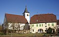
George's Church with rectory

Kellerhals from 1733

Horkheim Castle, stone house


- The old town hall in Schleusenstraße was mentioned as early as 1595, the core of the still medieval building was redesigned in Baroque style in 1768. Opposite the town hall at the entrance to Schlossgasse is the Horkheimer Kelter from 1774 with a bakery. The historic ovens were destroyed when the vaulted cellar below the wine press collapsed in 1985. In Schleusenstraße you can find the craftsman's house built around 1700 at Schleusenstraße 7, the oldest surviving residential building in the town. The house in Schleusenstraße 21 from 1765 was part of a former courtyard as a vineyard house.
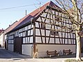
- The former Amos agricultural machinery factory in Talheimer Straße is a monument from the local industrial history; the company was originally founded in Horkheim in 1860. In the historical workshop building, built in half-timbered construction with brick infills, various exhibitions are held today.
- The Horkheim synagogue was built in 1859 in the area of today's Schlossgasse.
- The Horkheim lock and the Horkheim weir are located on the Neckar in Horkheim, and the Horkheim canal branches off from the Neckar here.
Wine press with bakery

Former Agricultural machinery factory

Horkheim synagogue


Sport and culture
The traditional TSB Horkheim ( Gymnastics and Singers Association Horkheim ) was created in 1934 through the merger of the Singers Association Horkheim , founded in 1859, and the gymnastics club Horkheim , founded in 1895. The most successful sports club is the handball club of the TSB; the 1st men's team plays in the 3rd handball league south (as of 2011).
Utzname of the population

The Utzname of the Horkheimers is Dachreiter . The rooftop fountain by Karl-Ulrich Nuss from 1989 addresses the former Utzname of the Horkheimers. According to the legend, a farmer from Horkheim is said to have climbed onto the roof of his house on the run from his tax debtors. There he was on the roof ridge like a ridge turret . With a fire hose and a water syringe, the ridge could be moved to leave the roof again. Alternative designs came from Dieter Läpple and Christiane Häringer , but the award-winning design by Karl-Ulrich Nuss.
literature
- Eugen Knupfer (edit.): Document book of the city of Heilbronn . Kohlhammer, Stuttgart 1904 ( Württemberg historical sources . N. F. 5)
- Description of the Oberamt Heilbronn . Kohlhammer, Stuttgart 1901/1903
- Eberhard Gönner: Book of arms of the city and district of Heilbronn with a territorial history of this area . Published by the city and district of Heilbronn and the Stuttgart archive directorate. Stuttgart 1965.
- Helmut Schmolz: Horkheim - From the royal village to Heilbronn district , in: One thousand years of Horkheim , Heilbronn 1976
Web links
Individual evidence
- ↑ Heilbronn Info Population Numbers . Retrieved September 14, 2018 .
- ↑ Monument topography Baden-Württemberg, Vol. 1.5 Stadtkreis Heilbronn, p. 192
- ↑ Communications from the Württ. And Bad. State Statistical Office No. 1: Results of the population census on December 31, 1945 in Northern Württemberg
- ^ Federal Statistical Office (ed.): Historical municipality directory for the Federal Republic of Germany. Name, border and key number changes in municipalities, counties and administrative districts from May 27, 1970 to December 31, 1982 . W. Kohlhammer, Stuttgart / Mainz 1983, ISBN 3-17-003263-1 , p. 464 .
- ^ City of Heilbronn, Administrative Report 1979–1982, p. 26.
- ↑ page 179 noble families: Wigmar
- ↑ Heilbronner Insights 2009 - Jewish Life in Heilbronn at stadtarchiv-heilbronn.de
- ↑ Günter Krause: Gerschtahewwel 100 percent. 18th big castle festival; Kirchhausen 3rd to 5th July 2009 (publisher Ortskartell Heilbronn-Kirchhausen), Heilbronn 2009, p. 5.
- ^ Gabriele Holthuis: City of Sculptures Heilbronn. Guide to art in public spaces. Städtische Museen Heilbronn, Heilbronn 1996, ISBN 3-930811-57-X ( Heilbronner Museum Catalog No. 60), p. 96 - p. 97.

Biberach | Böckingen | Frankenbach | Horkheim | Kirchhausen | Klingenberg | Neckargartach | Sontheim