Iga (Mie)
| Iga-shi 伊 賀 市 |
||
|---|---|---|
| Geographical location in Japan | ||
|
|
||
| Region : | Kinki | |
| Prefecture : | Mie | |
| Coordinates : | 34 ° 46 ' N , 136 ° 8' E | |
| Basic data | ||
| Surface: | 558.17 km² | |
| Residents : | 87,364 (June 1, 2019) |
|
| Population density : | 157 inhabitants per km² | |
| Community key : | 24216-1 | |
| Symbols | ||
| Tree : | Japanese red pine | |
| Flower : | Lilium japonicum | |
| Bird : | Colored pheasant | |
| town hall | ||
| Address : |
Iga City Hall 116 Marunouchi, Ueno Iga shi Mie 518-8501 |
|
| Website URL: | http://www.city.iga.lg.jp/ | |
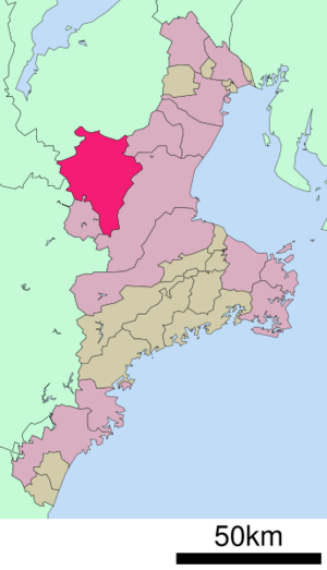
| Location Igas in Mie Prefecture | ||
Iga ( Japanese 伊 賀 市 , -shi ) is a city in the Japanese prefecture of Mie .
geography
Iga is west of Tsu and east of Nara .
history
It was created on November 11, 2004 as a result of the amalgamation of the city of Ueno ( 上 野 市 , -shi ), the communities Iga ( 伊 賀 町 , -chō ) and Ayama ( 阿 山 町 , -chō ), the villages of Shimagahara ( 島 ヶ 原 村 , - mura ) and Ōyamada ( 大 山 田村 , -mura ) of Ayama County , as well as of Aoyama ( 青山 町 , -chō ) of Naga County .
traffic
- Train:
- JR Kansai Main Line
- JR Kusatsu Line , to Kusatsu
- Kintetsu Osaka line
- Kintetsu Iga line
- Street:
- National roads 25, 163, 165, 368, 421, 422
Attractions
- Ueno Castle
- Matsuo Bashō's birthplace
sons and daughters of the town
- Matsuo Bashō (1644-1694), poet
- Hattori Dohō (1657-1730), poet
- Jirō Kawasaki (* 1947), politician
Personalities
- Hattori Hanzō (1541–1596), samurai and ninja
- Hakaru Hashimoto (1881-1934), pathologist and surgeon
Neighboring cities and communities
- Mie prefecture
- Shiga prefecture
- Nara prefecture
- Kyoto Prefecture
Web links
Commons : Iga (Mie) - Collection of images, videos and audio files


