
Itacaré
| Município de Itacaré | ||
|---|---|---|
|
Coordinates: 14 ° 17 ′ S , 39 ° 0 ′ W Município de Itacaré on the map of Bahia
|
||
| Basic data | ||
| Country | Brazil | |
| State | Bahia | |
| City foundation | 1732 | |
| Residents | 24,318 (2010) | |
| City insignia | ||
 |
||
| Detailed data | ||
| surface | 737.869 km 2 | |
| Population density | 33 people / km 2 | |
| height | 29 m | |
| Waters | Rio das Contas | |
| prefix | 73 | |
| Time zone | UTC −3 | |
| City Presidency |
Prefect: Antônio Mario Damasceno (Tonho de Anizio), PT (2017–2020) |
|
| Website | ||
 |
||

Itacaré , officially Portuguese Município de Itacaré , is a former fishing village on the coast of Bahia ( Brazil ), which has developed into a popular holiday resort, famous for its waves among surfers. According to the 2010 census, the community had 24,318 inhabitants, who are called Itacareens; the number of inhabitants was estimated by the IBGE as of July 1, 2018 at 27,891.
geography
The city is located at the mouth of the Rio das Contas River . The beaches in the area are atypical for northeastern Brazil: no long sandy beaches, but bays that are separated from each other by rocky sections, originally overgrown with coastal jungle. They look more like in southern Brazil.
Distances / arrival
- Ilhéus 70 km
- Salvador 369 km, via the BA-001
- Rio de Janeiro 1307 km
There is a new coastal road ( BA-001 ), which allows you to arrive from Ilhéus in just 1 hour 40 minutes by bus (almost every hour). The nearest airport is in Ilhéus.
climate
Tropical climate, the temperature varies around 20 to 30 ° C. In the main season (December to February) the thermometer can rise to 40 ° C. The rainy season is in March.
history
White history began with a church in the 17th century. In 1732, which is considered to be the founding year, the village became a municipality with the name São Miguel da Barra do Rio das Contas , it was known as Ubaitaba. Itacaré got its current name in 1931.
City structure
Since 1963 the place has been divided into two districts ( distritos ): Distrito de Itacaré and Distritio de Taboquinhas . Itacaré belonged to the statistical-geographic mesoregion Sul Baiano and the microregion Ilhéus-Itabuna from 1989 to 2017 .
City administration
Antônio Mario Damasceno (Tonho de Anizio) of the Partido dos Trabalhadores (PT) has been city prefect since the local elections in Brazil in 2016 for the term from 2017 to 2020 .
economy
The city had a GDP of 82,459,462 thousand R $ in 2008 with a GDP per inhabitant of 3129.63 real.
Tourism / attractions
- Ecotourism (nature reserve, waterfalls, hikes, adventure)
- Hikes to the individual beaches
- Canoe trips on the Rio das Contas and small streams
- A variety of beaches with waves suitable for surfers
- Capoeira schools

Praia de Itacarezinho

Praia de Itacarezinho
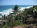
Praia de Itacarezinho

Engenhoca


beaches
- Concha
- Coroinha
- Costa
- Engenhoca
- Havaizinho
- Itacarezinho
- Jeribucaçú
- Pontal
- Prainha
- Resende
- Ribeira
- São José
- Serra Grande
- Siriaco
- Tiririca
Web links
- City Prefecture website (Portuguese)
- Instituto Brasileiro de Geografia e Estatística (IBGE): Bahia: Itacaré: Infográficos. Retrieved August 12, 2013 (Portuguese, brief history of the city).
Individual evidence
- ↑ a b Itacaré - Panorama. In: cidades.ibge.gov.br. IBGE , accessed August 1, 2019 (Brazilian Portuguese).
- ↑ Distance calculation with comochegar.com (Portuguese).
- ^ Instituto Brasileiro de Geografia e Estatística (IBGE): Bahia: Itacaré: Infográficos. Retrieved August 12, 2013 (Brazilian Portuguese).
- ↑ IBGE : Produto Interno Bruto dos Municípios 2004–2008. 2008, accessed August 12, 2013 (Portuguese).