
Jewish cemetery Battonnstrasse


The Jewish cemetery Battonnstrasse (also: Jüdischer Friedhof Börneplatz ) in Frankfurt am Main was first mentioned in a document in 1180 and was used until 1828. After the Holy Sand in Worms , it is considered the second oldest Jewish cemetery in Germany. The earliest still verifiable graves date from the year 1272. Up to the 16th century it was of supraregional importance, as it also served as a burial place for Jewish communities from the area between Aschaffenburg in Lower Franconia and Wetzlar in Central Hesse. Despite repeated desecrations, desecrations and destruction , some of the original buildings have been preserved to this day.
location


The burial site was initially outside the city, east of the Staufen wall , the Romanesque city fortification, which was being built at the same time . From about the middle of the 14th century, the cemetery was surrounded by new city fortifications . It was located in the district of Neustadt called "Judeneck" . Later on, Frankfurter Judengasse , the Jewish ghetto that existed from 1462 to 1796 , was adapted to the location of the cemetery area in urban planning.
The medieval burial ground is now in the Carrée between Battonnstrasse , Lange Strasse , Rechneigrabenstrasse and Kurt-Schumacher-Strasse . The Judengasse Museum and the Neuer Börneplatz Memorial are directly connected to the cemetery.
Access
The historically documented cemetery gate was always in the western or south-western enclosure and from the 16th century was located directly on the Judenmarkt, which later became Börneplatz. Access was accessible from 1780 via the hospital for foreigners, later: the Israelite hospital. In 1881 the access to the Orthodox Börneplatz synagogue had to give way and was relocated to the Schnurgasse, which was extended to the east. With the construction of the New Börneplatz in the mid-1990s, the cemetery gate also returned to its historically occupied place on the southwestern part of the cemetery wall.
history


middle Ages
High Middle Ages until 1180
The first settlement of Jews in Frankfurt am Main is dated around 1150. Until the Jewish cemetery was built, they were buried at the Garkarkplatz , which was directly connected to the former Salvator Church of the monastery of the same name to the east . Her remains were found there in large numbers during the reconstruction of Frankfurt after 1945 and buried right next to the crucifixion group in the cemetery adjacent to the east of today's imperial cathedral.
High Middle Ages from 1180
This Jewish cemetery is now regarded as one of the oldest testimonies to Jewish life in the city of Frankfurt am Main. It was created because of the crowded narrowness of the city center at that time. Its size is almost unchanged historically. It was created on the northern bank of the Braubach, a silted up tributary of the Main , the course of which at this point later corresponded to about a section of the irrigated city moat. From 1233 the Dominican monastery was built west of the cemetery behind the medieval Staufen wall .
The Jews who lived south of the Salvatorkirche could get to the grave sites in the Jewish cemetery through the Bornheimer gate of the Staufen wall to the northeast .
In 1241, many Frankfurt Jews were murdered during a pogrom known as the “Frankfurter Judenschlacht” and found their final resting place in the cemetery.
Late Middle Ages
From 1333 the Jewish burial place was enclosed by the new city wall around the so-called Neustadt, which had been redrawn with the permission of Emperor Ludwig the Bavarian , and has since been located within the city in the "Judeneck" and relatively close to the city center, today's old town . In the period that followed, the path from the old town center to the Jewish cemetery was shortened by several openings on the west side of the old Staufen wall.
Further pogroms directed against Jews developed during the plague that raged from 1348 onwards , culminating in the murder of all Frankfurt Jews during the so-called 2nd Frankfurt Jewish Battle of July 24, 1349. All of her property fell into disrepair, including her cemetery. The remains of these Jews were not buried in the cemetery as there was no longer a Jewish community to take care of them. From around 1360 onwards, Jews reluctantly settled in Frankfurt again, the largest property of which was the cemetery, which was again assigned to the community and bordered the custodian garden of the Bartholomäusstift at that time .
The wall of the Jewish cemetery was included in the city's defensive measures several times due to its strategic location on the south-eastern outskirts of the city - what was then known as the Judeneck . When Frankfurt sided with the candidate Günther von Schwarzburg in the king's election in 1349 and therefore faced an attack by the opposing king Karl IV , eleven oriels with loopholes for guards were installed around the old town and the Jewish cemetery . The Jewish cemetery was also prepared for defensive measures during the city war (1387–1389).
Starting in 1462, the Frankfurt Jews were given the municipal requirement to leave the area around the collegiate church of St. Bartholomew and settle in the Judengasse (following the course of the former wool pit in front of the Staufen wall). The Judengasse ran outside the Staufen wall and roughly parallel to its north-eastern part in the Neustadt, in an approximate curved line between Bornheimer Pforte and Mönchsturm, so it ran towards the Jewish cemetery (see city view by Georg Braun and Frans Hogenberg 1572). The city lords did not determine this proximity to the cemetery by chance.
Modern times
Early modern age
The entrance to the Jewish burial site was at the south-western end of the cemetery grounds in the alley Hinter der Judenmauer , the name of which referred directly to the cemetery wall. This lane ran between Wollgraben (or later the southern end of Judengasse ) and Allerheiligengasse (see bird's eye view plan by Matthäus Merian 1628) at the western end of the cemetery area and along the north-western cemetery wall. The street Behind the Judenmauer found its north-eastern extension in the Breite Gasse (see city map by Johann Hochester 1792, city plans by Christian Friedrich Ulrich 1811 and 1819, city map by Julius Eduard Foltz-Eberle 1852, city map by Friedrich August Ravenstein 1862). In the north, east and south the cemetery was inaccessible, it was surrounded by buildings and gardens. At least temporarily, however, there seems to have been a gate on the eastern cemetery wall, possibly in the context of defensive measures. Directly next to this gate was a small building, possibly a bay window with loopholes for a guard. At least this is implied by the siege plan of the city of Frankfurt am Main based on Conrad Faber von Creuznach from 1552.
In 1780, the foreign hospital (later: Israelitisches Hospital) for the residents of the Judengasse ghetto was built right in front of the entrance to the cemetery grounds . Access to the cemetery was now possible via the hospital property. During the draining of the fishing field - known as New plant designated area south of the Jewish cemetery to the Main - from 1793 and the demolition of the city fortifications was immediately prior to the southwest end of the cemetery, a larger square, which since the 16th century, held Jews market , on which the Jewish population of the city and the surrounding area offered their goods for sale, gave significantly more space.
1806-1871
On September 16, 1828, the last burial took place in the completely overcrowded cemetery. Afterwards, the cemetery on Rat-Beil-Straße , which was newly laid out at the same time as the main cemetery, was used, and from 1929 the New Jewish Cemetery on Eckenheimer Landstraße . The older cemetery was retained; an inviolable rest for the dead applies to Jewish burial sites, the dissolution of graves and exhumations are excluded.
Around 1840, in front of the southern cemetery wall, on the site of the former wooden yard of the Jews ( Rechneigrabenstrasse 14–16), the schoolhouse of the Israelite community was built, which was considered the most beautiful building in Frankfurt at the time. From 1845 this building was used by the Israelitische Volksschule and the Philanthropin , who moved from the composting yard that bordered the Dominican monastery to the south.
1871-1933
The former Israelitische Hospital, which was located on the western part of the cemetery and was still built in the context of the Frankfurt Ghetto Judengasse , was demolished after more than a hundred years in favor of the Orthodox Horovitz synagogue built in 1881/82 , which now faces the there bordered newly drawn cemetery wall. The construction of this synagogue, which lay like a crossbar in front of the previous entrance to the cemetery, resulted in the need for a new gate to the Jewish cemetery, which was broken into the cemetery wall in the Schnurgasse , which has now been extended to the east (section is now called Battonnstrasse ).
Around 1900, when Rabbi Markus Horovitz cataloged the gravestone inscriptions on the 11,850 m² cemetery area between Schnurgasse and Börneplatz, around 6,500 grave sites were recorded, as it turned out from 1991/92 on the occasion of a new inventory, these were not all.
1933-1945
Immediately after the National Socialist seizure of power , the Gauleiter of Hessen-Nassau, Jakob Sprenger , demanded that the city remove the gravestones from the Old Jewish Cemetery and recommended that they be rededicated in a public park or a children's playground. At first there were legal concerns in the way of this request, at times the matter was forgotten or dealt with subordinately. Only Börneplatz , named after the native Jew Ludwig Börne since 1885 , was renamed Dominikanerplatz in 1935. It wasn't until 1978 that it got its previous name back.
After the November pogroms in 1938 , the city of Frankfurt urged the Jewish community in the “Jewish Treaty” of April 3, 1939, among other things, to sell the cemetery grounds. In 1942, the municipal building authorities tried to find open spaces in order to have a centrally located rubble dump for any destruction of the old town by bombing. The building authorities considered leveling the old Jewish cemetery. The Lord Mayor of Frankfurt, Friedrich Krebs , therefore issued an order for the destruction of the cemetery and the grave sites in November 1942.
As a result, around two thirds of the historical gravestones were mostly mechanically smashed and left in ruins. If necessary, these should serve as rubble stones for the rebuilding of war-torn walls. Fragments of glass scattered all over the cemetery as relics of the windows of houses in the old town that were destroyed in the air raids on Frankfurt am Main still bear witness to the short period as a rubble dump. To this end, around fifty trees were felled and cleared on the cemetery grounds, areas were leveled and the original ensemble was permanently destroyed. At least, however, the Historical Museum was instructed to select significant gravestones in order to preserve them. In this way, about 175 tombstones ended up in the newer Jewish cemetery on Rat-Beil-Strasse during the war .
1945 until today
These 175 gravestones were put back in the old Jewish cemetery in the 1950s for an initial repair phase. However, since their original location had not been mapped, they are no longer in their original location today. The cemetery is therefore now only in its original condition to a very limited extent. Only the eastern burial ground still gives the impression of a medieval Jewish cemetery. Gravestone rubble still testifies to the destruction during the Nazi era .
Around 2,675 tombstones have been completely preserved, around 3,500 fragments, of which 500 have now been put together virtually using computer technology and are thus readable again. Work has been going on for several years on their physical reconstruction. However, some gravestones are so weathered that only a few Hebrew characters have survived and they make identification impossible. An important historical work is the 1901 catalog "The inscriptions of the old cemetery of the Israelite community" by Rabbi Markus Horovitz , which documents many tombstones and inscriptions that were still preserved at that time. From 1991/92 the city of Frankfurt had all tombstones still preserved today recorded by the Salomon Ludwig Steinheim Institute , supervised by Frankfurt's Jewish Museum. Since then, more than 200 additional tombs have been discovered compared to the cataloging carried out by Markus Horovitz.

Between 1996 and 2010, 11,957 stones with the names of Jewish citizens of Frankfurt were embedded in the plaster on the outside of the cemetery wall to commemorate their fates during the Nazi era . They are part of the Neuer Börneplatz memorial that was inaugurated in 1996. Below is a stone for Anne Frank , surrounded by those for her family members. Another memorial stone commemorates the Frankfurt boy Hans Helmut Michel, whose biography was included in the plot of the French feature film Auf Wiedersehen, Kinder (Original: Au revoir, les enfants) by Louis Malle . The role of the Jewish boy Kippelstein or Jean Bonnet ( code name) corresponds to the story of Hans Helmut Michel. A stone was executed without names or dates; it stands for all nameless, forgotten or undocumented fates.
Behind the museum, a wide, modern gate was integrated into the cemetery wall at Neuer Börneplatz , which consists of two metal gates. Both are broken by a Hebrew lettering: Beth Ha'Chaim - House of Life. This gate was positioned very close to the historic cemetery entrance, which has existed there since the High Middle Ages.
Today, the footpath section along the north-west facing cemetery wall to the confluence with Battonnstrasse still largely corresponds to the historical course of the former alley behind the Jewish wall , which was densely built up with small houses on the opposite side of this section (house numbers 20-28). The north-western corner of the cemetery wall on Battonnstraße also reveals a distinctive interior corner since that time . At the time of the alley behind the Jewish Wall, a house with the number 27 was built there (see city maps by Christian Friedrich Ulrich, 1811 and 1819, city map by Julius Eduard Foltz-Eberle 1852, city map by Friedrich August Ravenstein 1862).
The current cemetery wall roughly corresponds to the earlier course of the enclosure, but was subject to numerous revisions due to the changes in the area (bay extension for city defense, construction of the hospital for foreigners, extension of the Schnurgasse to the east, synagogue construction and destruction, etc.), which are based on to partially reproduce old city maps. The cemetery enclosure experienced the greatest degree of change at its south-western end. In 1780 the hospital for foreigners, which later became the Israelite Hospital, was set up on the section leading to Neuer Börneplatz , where the two-winged metal gate is located today. This wide access to the cemetery is roughly at the site of the cemetery gate, which has been historically documented for centuries. The current course of the cemetery wall in the north, east and south largely corresponds to the historical course of at least the 19th century. At the beginning of the 20th century, the wall was much narrower and possibly higher than it is today.
Timetable
| date | event | Originator |
|---|---|---|
| 1180 | First documentary mention, located on the northern bank of the Main silted arm Braubach, west of the resulting at the same time Staufenmauer |
|
| 1241 | Burial of the victims of the pogrom "Frankfurter Judenschlacht" |
|
| July 1272 | Oldest still legible tombstone |
|
| 1349 | Addition of defensible bay windows to the cemetery wall |
|
| around 1388 | The cemetery wall serves as a line of defense in the city war (1387–1389) |
|
| up to the 16th century | Also used by Jewish communities from the Aschaffenburg and Wetzlar area |
|
| 1780 | Integration of the foreign hospital of the Frankfurt ghetto Judengasse into the cemetery area |
|
| September 16, 1828 | Last burial |
|
| 1840 | Construction of the Israelite school house in front of the southern cemetery wall on the former wooden yard of the Jews |
|
| from 1845 | The philanthropist moves to the new school building in front of the southern cemetery wall |
|
| 1880/81 | Demolition of the former Israelite Hospital (hospital for foreigners) |
|
| 1881/82 | Extension of the orthodox Horovitz synagogue , relocation of the cemetery entrance to Schnurgasse |
|
| Around 1900 | Cataloging of the tombstones and inscriptions by Rabbi Markus Horovitz , result of the census: around 6,500 grave sites |
|
| April 1933 | Gauleiter Jakob Sprenger called for the cemetery to be rededicated as a public park or playground |
|
| April 3, 1939 | "Jewish contract" enforced by coercion, through which u. a. the cemetery grounds fall to the city |
|
| 1942 | The city's building authority is focusing on the cemetery area as a rubble dump for bomb debris in the old town |
|
| November 1942 | Lord Mayor Friedrich Krebs issues instructions to destroy the grave sites, around fifty cemetery trees are cut down, 175 important gravestones are selected by the Historical Museum and stored in the Jewish cemetery at Rat-Beil-Strasse |
|
| October 1943 | After the heavy air raid on the 4th of the month, rubble from the old town is dumped in the cemetery area |
|
| March 20, 1946 | The Allied Military Administration has a sign put up next to the Battonnstrasse cemetery entrance , commemorating the Orthodox synagogue on Börneplatz that was destroyed on November 9, 1938 |
|
| 1950s | The 175 gravestones stored during the war are brought back and, in the absence of knowledge of the original locations, positioned on the inner cemetery wall |
|
| from 1991/92 | Cataloging of the gravestones and inscriptions by the Salomon Ludwig Steinheim Institute, compared to Rabbi Horovitz's catalog, 113 previously undocumented gravestones are discovered |
|
| June 16, 1996 | Integration of the accessible part of the cemetery outer wall into the Neuer Börneplatz memorial |
|
| 1996, 2006, 2010 | Installation of 11,957 name stones for the fate of Frankfurt Jews during the Third Reich on the outer cemetery wall, new cemetery gate at Neuer Börneplatz |
|
| current | Creation of an online database with the Hebrew inscriptions and a transcription of all still legible gravestones (see web links); virtual and physical reconstruction of destroyed tombstones |
|
Tombs

Type of grave sites
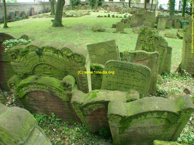
Jewish gravestones ( Mazevot ) in Frankfurt am Main have various peculiarities that differentiate them regionally and internationally. The majority of the surviving tombstones, mostly between 100 and 150 cm high, are made of the red Main sandstone that is common in Frankfurt am Main . However, the oldest surviving tombstones from the High Middle Ages are smaller. They usually close with a differently designed round arch, the stones from the 15th to the middle of the 16th century show a horizontal finish. After this period, retracted round arches are common, with rosettes on the left and right shoulders until the beginning of the 18th century , later decorated with volutes .
The usual Jewish symbols such as blessing priestly hands and Levite jug are rarely seen, official symbols are completely absent. A special feature of the gravestones in this cemetery is the frequent depiction of house signs since the middle of the 17th century. They refer to the house in Frankfurt's Judengasse where the deceased lived (e.g. fish trap , shield, shoe, pan, rabbit and many more). Such house signs can otherwise only be found in the Jewish cemetery in Hanau .
The Hebrew inscriptions, which mostly fill the entire front of a tombstone, characterize the buried person briefly, but often also in detail and lavishly with quotations from traditional literature, rhymes, acrostic poems , chronograms and puns. Since the mid-16th century, most gravestones have had headers indicating the name and title of the deceased. German inscriptions, on the other hand, can hardly be found in this cemetery; they only become more common in the younger Jewish cemeteries in Frankfurt.
The order of the tombstones in the originally preserved area is very narrow and irregular, which is typical for centuries-old Jewish cemeteries due to the very dense occupancy in the area that cannot be expanded. The burial took place in family groups, with women - if they came from Frankfurt am Main - not buried with their husbands but with their fathers. The graves were directed towards Jerusalem , the place of the hoped-for resurrection at the end of days.
Personalities

The grave of Meir Rothschild ben Anschel Rothschild , the founder of the Rothschild banking house, is one of the most famous grave sites on the historic cemetery grounds . Other gravestones of important personalities were set up in the honor grove in the southwestern part of the cemetery, for example by Nathan ben Simeon ha-Kohen Adler , by Frankfurt chief rabbi Jakob Jehoschua Falk , Pinchas Ben Zwi Hirsch Ha-Levi or Meir ben Rabbi Yaakov Schiff .
Oldest grave site
.jpg)
The oldest surviving tombstone for Channa bat Alexandern shows the date of death July 12, 1272. It measures 73 × 63 × 27 cm and was placed on the inner cemetery wall. It is therefore no longer in its original place. The Hebrew inscription is translated line by line:
- I was erected, a stele,
- at the heads of those who are respected,
- Mrs. Channa daughter of the Lord
- Alexanders,
- which (is) different 14th of the moon
- Aw in the year 5 thousand
- 32 of the count. Be it
- her soul in the garden of eden.
- A (men) Sela.
Inventory
In view of the historical significance and the degree of preservation of the remaining tombstones in the cemetery, there was a need for an inventory and epigraphic recording of the grave inscriptions. These can be accessed online in their Hebrew original and the German transcription via a database (Epidat) of the Salomon Ludwig Steinheim Institute. The link can be found below under the web links.
Access
The cemetery is permanently closed, but the key can be borrowed if you wish to visit the neighboring Museum Judengasse by depositing your identity card (except on Mondays and Saturdays). Guided tours are offered every second Sunday. To do this, you need to register by telephone at the Museum Judengasse. Regular admission to the museum must be paid for the guided tour. Kippot (headgear) can be borrowed from the museum for male visitors .
literature
- Markus Horovitz : The inscriptions of the old cemetery of the Israelite community in Frankfurt aM J. Kauffmann , Frankfurt am Main 1901.
- Isidor Kracauer: History of the Jews in Frankfurt a. M. (1150-1824) . 2 volumes, J. Kauffmann, Frankfurt am Main 1925/1927.
- Eugen Mayer: The Frankfurt Jews. Look into the past. Waldemar Kramer publishing house, Frankfurt am Main 1966.
- Valentin Senger (author), Klaus Meier-Ude (photographer): The Jewish cemeteries in Frankfurt. Verlag Waldemar Kramer, Frankfurt am Main 1985, ISBN 3-7829-0298-X , pp. 10-20 (3rd revised edition under the title: The Jewish cemeteries in Frankfurt am Main. Fachhochschulverlag, Frankfurt am Main 2004, ISBN 3- 936065-15-2 .)
- Fritz Backhaus (Ed.): "And Jehuda's daughter was great with lamentation and lament ...". The murder of the Frankfurt Jews in 1241. Jan-Thorbecke-Verlag, Sigmaringen 1995 (series of publications by the Jewish Museum Frankfurt am Main, Volume 1), ISBN 3-7995-2315-4 .
- Michael Brocke : The old Jewish cemetery in Frankfurt am Main. Unknown monuments and inscriptions. Jan Thorbecke Verlag, Sigmaringen 1996, ISBN 3-7995-2322-7 .
Web links
- Website of the Jewish Museum Frankfurt on the cemetery
- Edition of the grave inscriptions of the Jewish cemetery Battonnstrasse on Epidat, the epigraphic database of the Salomon Ludwig Steinheim Institute
- Jewish cemetery Battonnstrasse (Börneplatz) on Alemannia Judaica
Individual evidence
- ↑ Battonnstrasse cemetery on: jg-ffm.de
- ^ Valentin Senger, Klaus Meier-Ude: The Jewish cemeteries in Frankfurt , Verlag Waldemar Kramer, Frankfurt am Main 1985, pp. 10-20
- ↑ Photo: Model of the Judengasse with Judenmarkt, Israelitisches Hospital, medieval Jewish cemetery and Israelitischer Krankenkasse, center left Dominican monastery on: lilit.de
- ↑ Photo: model of Judengasse, red arrow points to Steinernes house with mikveh, above it is a medieval Jewish cemetery with an Israelite hospital. Row of houses and Israelitische Krankenkasse at the location of today's Neuer Börneplatz at: lilibit.de
- ↑ Satellite photo: Neuer Börneplatz Memorial at: lilit.de
- ↑ Last burial in the Old Jewish Cemetery at Judenmarkt on: steinheim-institut.de
- ↑ Photo: Gravestones in the Old Jewish Cemetery, 1917 on: ffmhist.de
- ↑ Photo: Historic tombstones in the Old Jewish Cemetery in Frankfurt am Main ( page no longer available , search in web archives ) Info: The link was automatically marked as defective. Please check the link according to the instructions and then remove this notice. on: panoramio.com
- ↑ Photo: Historic tombstones in the Old Jewish Cemetery in Frankfurt am Main on: alemannia-judaica.de
- ↑ Photo: Dense row of historical gravestones in the Old Jewish Cemetery, Battonnstrasse on: flickr.de
- ↑ Photo: Piled tombstone rubble on the Old Jewish Cemetery Battonnstrasse, 1985 on: ffmhist.de
- ↑ The Old Jewish Cemetery on Battonnstrasse at: ffmhist.de
- ↑ Photo: Gravestones and gravestone rubble on the Old Jewish Cemetery, Battonnstrasse on: flickr.de
- ^ "961 small name boards", in: Frankfurter Allgemeine Zeitung, September 5, 2006 on: faz.net
- ^ Commemoration of the Holocaust: Little Albert . In: Frankfurter Rundschau, January 26, 2010 at: fr-online.de
- ↑ Photo: Cemetery wall with embedded memorial stones on Börneplatz ( page no longer available , search in web archives ) Info: The link was automatically marked as defective. Please check the link according to the instructions and then remove this notice. on: fotocommunity.com
- ↑ Photo: cemetery wall with embedded memorial stones at Börneplatz on: flickr.de
- ↑ Photo: memorial stones in the outer wall of the old Jewish cemetery Börneplatz on: flickr.de
- ↑ Photo : Outer wall of the old Jewish cemetery Börneplatz on: flickr.de
- ↑ Photo: Memorial stone for Anne Frank in the outer wall of the Old Jewish Cemetery Börneplatz on: flickr.de
- ↑ Photo: Memorial stones for Anne Frank's family in the outer wall of the Old Jewish Cemetery at Börneplatz on: flickr.de
- ^ Note by email from January 26, 2012 from Dr. Martin Liepach, Liebig School, Pedagogical Center Fritz Bauer Institute and Jewish Museum Frankfurt am Main
- ↑ Photo: Memorial stone for the forgotten on the outer wall of the Old Jewish Cemetery Börneplatz on: flickr.de
- ↑ Photo: Entrance gate to the Old Jewish Cemetery, Neuer Börneplatz on: flickr.de
- ↑ Photo around 1900: View from the northeast from Schnurgasse (part of it is now called Battonnstrasse ) to the medieval Jewish cemetery with an orthodox synagogue and a row of houses in place of today's New Börneplatz , on the right St. Bartholomew's Cathedral and Dominican monastery with monastery church on: lilit.de
- ↑ Old Jewish Cemetery Frankfurt am Main on: judengasse.de
- ↑ Research results of the Salomon Ludwig Steinheim Institute at the University of Duisburg-Essen, Nathanja Hüttenmeister , MA)
- ↑ Transcript of the Hebrew gravestone inscription by Mayer Amschel Rothschild on: steinheim-institut.de
- ^ Translation of the Hebrew inscription on the oldest gravestone from 1272 to: steinheim-institut.de
- ↑ Photo of the oldest gravestone in the old Jewish cemetery Battonnstrasse from 1272 on: steinheim-institut.de
- ↑ Old Jewish cemetery on Battonnstrasse. 800 Years of Jewish History , website of the Jewish Museum Frankfurt , accessed on January 11, 2020

Battonnstrasse | Mountains, old | Bergen, new | Bockenheim | Fechenheim / Offenbach | Frankfurt am Main, new | Griesheim, first | Griesheim, second | Griesheim, third | Heddernheim, old I | Heddernheim, old II | Niederursel, old | Niederursel, new | Rat-Beil-Strasse | Rödelheim, old | Rödelheim, new
Coordinates: 50 ° 6 ′ 44.8 " N , 8 ° 41 ′ 23.3" E