Jakobsweg Purkersdorf – Göttweig
| Jakobsweg Purkersdorf – Göttweig | |
|---|---|
 Destination of all the Way of St. James: Cathedral of Santiago de Compostela |
|
| Data | |
| length | 67 km |
| location | Mostviertel ( Wienerwald , Tullnerfeld , Dunkelsteiner Wald ) |
| Starting point |
Purkersdorf 48 ° 12 '26.7 " N , 16 ° 10' 31.9" E |
| Target point |
Furth near Göttweig 48 ° 17 ′ 11 " N , 15 ° 41 ′ 47.5" E |
| Type | Long-distance hiking trail |
| Level of difficulty | light |
| season | all year round |
| particularities | Herzogenburg Abbey , Göttweig |
The Jakobsweg Purkersdorf – Göttweig is a 67 kilometer long section of the Jakobsweg Austria in the Austrian Jakobswegen network, signposted since 2011 .
It forms the first entry into the Austrian Way of St. James northwest of the Vienna city limits and from there leads through fourteen Lower Austrian communities in the northeastern Mostviertel in the districts of St. Pölten , Tulln and Krems , including two municipalities with Purkersdorf and Herzogenburg.
The signposted Jakobsweg essentially corresponds to the historical route explored by Peter Lindenthal . The pilgrimage route runs in the Troppberg hiking region through the landscape of the Vienna Woods and reaches the edge of the Tullnerfeld and finally the Traisental in Sieghartskirchen . The foothills of the Dunkelsteiner Forest begin further west .
The Austrian Way of St. James is west of the UNESCO - World Heritage Göttweig through the Wachau St. James continued.
description
The Jakobsweg Purkersdorf – Göttweig begins in Purkersdorf , where there is a connection to other local, regional and supraregional hiking trails. a. Hiking trails around the Lainzer Tiergarten , the Vienna Woods circular route connecting route 444, the Lower Austrian state circular route , the pre-alpine route , the European long-distance hiking route E4 ( Pyrenees - Lake Balaton ), international Marienpilgerweg I23 ( Czestochowa - Mariazell ).
From the Jakobskirche on Jakobsplatz in Purkersdorf, the route first runs up the Troppberg in the market town of Gablitz to the Alexander-Kendl-Warte on the highest point of the mountain at 542 meters above sea level. A. and via Rabenstein, the ruins of the monastery on Riederberg and the ruins of Ried am Riederberg in the municipality of Sieghartskirchen .
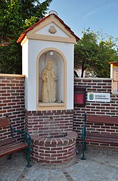
The further path to Asperhofen leads through Siegersdorf , where a pilgrim's self-catering hut was built next to a Jacob's fountain . In 2007 a wayside shrine was blessed with a statue of St. James in the village . On the way to Würmla , the Way of St. James leads through the community of Michelhausen in the village of Michelnorf, past the picture oak and the iron hand.
On the way to the baroque Augustinian canons of Herzogenburg Abbey , the Way of St. James runs through villages in the communities of Weißenkirchen an der Perschling (including Langmannersdorf with the Jacob's fountain, which was blessed in 2009) and chapels . The geographical center of the federal state of Lower Austria is located in the municipality of Kapelln at the Max-Schubert-Warte .
Sankt Andrä an der Traisen , a village in the city of Herzogenburg , is the location of an abandoned monastery (today the Geriatric Center of the City of Vienna) with a monastery church (today the parish church) and beautiful Paul Troger frescoes and high altar from the Rococo period in the first half of the 18th century Century.
The Jakobsweg joins the Wachau Jakobsweg in Furth below Göttweig Abbey . On the way, you will pass some villages in the communities of Statzendorf , Inzersdorf-Getzersdorf and Paudorf . In Paudorf, the Lower Austrian Mariazellerweg ( Waldviertler Freiwald / South Moravia - Mariazell ) crosses the Jakobsweg.
Project
The Jakobsweg Purkersdorf-Göttweig is a community and cross-regional joint project of the communities of the LEADER regions Donauraum – Tullnerfeld – Traisental and Elsbeere Wienerwald as well as the small region Troppberg .
The project included setting up around 220 signposts and information boards for each community. A folder and a route map in digital form have been developed and added to websites. Local initiatives created rest / reflection stations and Jakobs drinking fountains , and existing benches and rest areas were added.
literature
- Peter Lindenthal : On the Way of St. James through Austria - Preßburg to Feldkirch in 28 stages, exact directions with hiking maps , 6th revised and updated edition, Innsbruck 2008, ISBN 9783702221997 (first edition 1999)
Web links
Individual evidence
- ↑ Jakobsweg Purgersdorf - Göttweig opened
- ↑ The way - the ways to Mariazell ( Memento of the original from November 1st, 2012 in the Internet Archive ) Info: The archive link was inserted automatically and has not yet been checked. Please check the original and archive link according to the instructions and then remove this notice.
- ↑ opening Pilgrim Purkersdorf -Göttweig
- ↑ Documents on the Way of St. James Purkersdorf – Göttweig (PDF; 352 kB)
