
Perschling
|
Perschling
|
||
|---|---|---|
| coat of arms | Austria map | |
 |
|
|
| Basic data | ||
| Country: | Austria | |
| State : | Lower Austria | |
| Political District : | Sankt Pölten-Land | |
| License plate : | PL | |
| Main town : | Weißenkirchen an der Perschling | |
| Surface: | 23.8 km² | |
| Coordinates : | 48 ° 16 ′ N , 15 ° 46 ′ E | |
| Height : | 220 m above sea level A. | |
| Residents : | 1,411 (January 1, 2020) | |
| Population density : | 59 inhabitants per km² | |
| Postal code : | 3142 | |
| Area code : | 02784 | |
| Community code : | 3 19 46 | |
| NUTS region | AT123 | |
| Address of the municipal administration: |
Hauptstrasse 21 3142 Perschling |
|
| Website: | ||
| politics | ||
| Mayor : | Reinhard Breitner ( ÖVP ) | |
|
Municipal Council : ( 2020 ) (19 members) |
||
| Location of Perschling in the Sankt Pölten-Land district | ||
  |
||
| Source: Municipal data from Statistics Austria | ||

Perschling (since December 1, 2015, previously Weißenkirchen an der Perschling ) is a municipality with 1411 inhabitants (as of January 1, 2020) in the district of Sankt Pölten-Land in Lower Austria .
geography
Perschling is located in the Mostviertel in Lower Austria, in the Traisental wine-growing region. The area of the municipality covers 23.8 square kilometers. 16.7 percent of the area is forested.
Community structure
The municipal area comprises the following 10 localities (population in brackets as of January 1, 2020):
- Grunddorf (30)
- Gunnersdorf (44)
- Haselbach (61)
- Langmannersdorf (367)
- Murstetten (294)
- Obermoos (8)
- Perschling (267)
- Weißenkirchen an der Perschling (284)
- Wieselbruck (19)
- Winkling (37)
history
In ancient times, the area was part of the Noricum province .
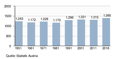
Population development
politics
Mayor of the community is Reinhard Breitner, head of office Christine Wegscheider. After the 2020 municipal council elections, there will be the following distribution of mandates with a total of 19 seats in the municipal council :
- ÖVP 14 seats, FPÖ 4 seats, SPÖ 1 seat.
Culture and sights
- Catholic branch church Perschling-Haselbach hl. Laurentius
- Local history museum in the Perschling parish hall
economy
In 2001 there were 54 non-agricultural workplaces, and according to the 1999 survey there were 85 in agriculture and forestry. According to the 2001 census, the number of people in employment in the place of residence was 610. In 2001, the employment rate was 47.63 percent.
societies
- Weißenkirchner Stubenmusik (ensemble consisting of 2 violins, tenor flute, clarinet, guitar, double bass)
- Vocal ensemble Klangbogen (mixed choir, formerly "Weißenkirchner Sängerrunde")
- Weissenkirchen parish choir and orchestra
- Lower Austria Music School. center
- Trachtenmusikkapelle Murstetten
- Perschlingtaler village music
- Country youth in Weißenkirchen
Web links
- Parish Perschling Homepage of the parish
- 31946 - Perschling. Community data, Statistics Austria .
Individual evidence
- ↑ Provincial Law Gazette for Lower Austria of November 30, 2015, 108th announcement in the RIS
- ↑ Statistics Austria: Population on January 1st, 2020 by locality (area status on January 1st, 2020) , ( CSV )
- ↑ Results of the municipal council election 2020 in Perschling. Office of the Lower Austrian State Government, January 26, 2020, accessed on February 25, 2020 .

Altlengbach | Asperhofen | Böheimkirchen | Brand-Laaben | Eichgraben | Frankenfels | Gablitz | Gerersdorf | Hafnerbach | Haunoldstein | Herzogenburg | Hofstetten-Grünau | Inzersdorf-Getzersdorf | Kapelln | Karlstetten | Box near Böheimkirchen | Kirchberg an der Pielach | Kirchstetten | Loich | Maria-Anzbach | Markersdorf-Haindorf | Mauerbach | Michelbach | Envious | Neulengbach | Neustift-Innermanzing | Nussdorf ob der Traisen | Ober-Grafendorf | Obritzberg-Rust | Perschling | Press tree | Prinzersdorf | Purkersdorf | Pyhra | Rabenstein an der Pielach | Schwarzenbach an der Pielach | St. Margarethen an der Sierning | Statzendorf | Stössing | Traismauer | Tullnerbach | Weinburg | Wilhelmsburg | Wölbling | Wolf pit
Cadastral communities: Grunddorf | Gunnersdorf | Haselbach | Langmannersdorf | Murstetten | Obermoos | Perschling | Weißenkirchen an der Perschling | Wieselbruck | Winkling
Locations: Grunddorf | Gunnersdorf | Haselbach | Langmannersdorf | Murstetten | Obermoos | Perschling | Weißenkirchen an der Perschling | Wieselbruck | Winkling
Villages: Grunddorf • Gunnersdorf • Haselbach • Langmannersdorf • Murstetten • Perschling • Weißenkirchen an der Perschling • Winkling hamlet: Obermoos • Wieselbruck
Counting district: Weißenkirchen adP | Murstetten