
I remember
|
district 601 of Cologne |
|
|---|---|
 |
|
| Coordinates | 51 ° 1 '31 " N , 6 ° 57' 31" E |
| surface | 12.2 km² |
| Residents | 5756 (December 31, 2017) |
| Population density | 472 inhabitants / km² |
| Incorporation | Apr 1, 1922 |
| Post Code | 50769 |
| prefix | 0221 |
| Borough | Chorweiler (6) |
| Transport links | |
| Highway |
|
| Light rail line | 12 |
| Bus routes | 121 124 |
| Source: 2017 residents . (PDF) Cologne district information | |
Merkenich is a district in the north of Cologne on the left bank of the Rhine in the borough of Chorweiler .

location
The Merkenich district comprises the area of the three Rhine villages (from south to north) Merkenich, Rheinkassel and Langel as well as the industrial and commercial areas to the west of it. The village of Feldkassel , which was completely demolished in the 1970s, was located here . This area is bordered by the Fühlinger See . Kasselberg is located southeast of Rheinkassel and consists of an inn, a campsite and a few residential buildings. Kasselberg lies in front of the Rhine dike and is inundated even at minor floods. Otherwise, Merkenich has been well protected for a few years by an elevation and stabilization of the dam.
The place Langel should not be confused with the Langel district in the south of Cologne on the right bank of the Rhine .
history


The four Rhine villages Merkenich, Rheinkassel, Langel and Kasselberg lay along the Roman road connection from Cologne via Neuss and Xanten to Nijmegen . Since the Rhine was the border of the Roman Empire, there were watchtowers at regular intervals. Such a watchtower is probably the basis of the Merkenich parish church of St. Brictius . In 1885, when the old Merkenich church was demolished, a Roman consecration stone was found. It is not clear whether the Romanesque church of St. Amandus in Rheinkassel also rests on such a tower. This is supported by the fact that it lies opposite the Wupper estuary and that river estuaries have been specially monitored. In the area around the demolished village of Feldkassel near Cologne-Fühlingen there were several brickworks in Roman times. Roof tiles were also manufactured near Feldkassel in the 19th and early 20th centuries.
The Merkenich church was probably founded in Franconia, as the patronage of Brictius suggests that it was a Franconian church. The name Lachem, which was later referred to by the farm names Groß and Klein Lachem, located west of Merkenich on today's Exxon site, was first mentioned in 1047. Merkenich was first listed in March 1236 in a sales deed in which a Knight of Merkenich was also named. In the Middle Ages Merkenich was shaped by large courtyards, most of them owned by Cologne's monasteries and monasteries. The place belonged to the Electoral Cologne Office Hülchrath . In 1794 French revolutionary troops occupied Merkenich. The place now belonged to Mairie Worringen in the canton of Dormagen in the Arrondissement of Cologne in the Département de la Roer . After the Congress of Vienna , Merkenich came to the Kingdom of Prussia . 1816 the town was part of the mayor's Worringen in the district of Cologne in Cologne Region . After the First World War , the British military confiscated the Groß-Lachem estate near Merkenich, as it was an imperial property. On April 1, 1922, the mayor's office of Worringen was incorporated into the city of Cologne with Merkenich, Rheinkassel, Kasselberg and Langel. When the Ford plants in Cologne-Niehl were built directly on the Rhine in the 1930s , they interrupted the direct road connection from Merkenich to Cologne-Niehl . In 1938 Merkenich received a new school building, at Spoerkelhof, with a new teachers' house. At the end of the 1950s, a heating and power plant and the Esso port were built south of Merkenich . An Esso refinery was built to the west of Merkenich on the area of the Klein-Lachem and Groß-Lachem manors . After the site stopped producing fuel and only began producing other petroleum products, the facility became an Exxon Chemicals facility.
On October 7, 1963 the four localities Kasselberg, Langel, Feldkassel and Rheinkassel were assigned to Merkenich, before they belonged to Cologne-Fühlingen .
Population development
The percentage of foreigners is given in brackets.
| 1980 | 1990 | 1995 | 2000 | 2001 | 2002 | 2003 | 2004 | 2005 | 2013 |
|---|---|---|---|---|---|---|---|---|---|
| 4,893 (22.4) | 4,882 (17.2) | 5,238 (14.7) | 5,387 (14.2) | 5,412 (13.8) | 5,506 (14.4) | 5,614 (14.5) | 5,616 (14.1) | 5,638 (12.7) | 5,752 (13.3) |
The unemployment rate in December 2013 was 5.3 percent.
religion
- Catholic Church of St. Brictius
- Catholic Church St. Amandus (Rheinkassel)
- Catholic Cohnenhof Chapel (Langel)
- Evangelical St. Andrew's Church
- Islamic Community Center (Feldkassel)
Economy and Infrastructure

Industry
While Rheinkassel and Langel, with their location on the Rhine and surrounded by fields, are among the more popular residential areas of Cologne, Merkenich is surrounded by industry: to the south is the Merkenich thermal power station , which towers over the town with its 250 meter high chimney; to the west the chemical plants of Wacker and ExxonMobil ; to the northwest the development and spare parts center of the Ford works and on the opposite side of the Rhine the city of Leverkusen with the Chempark .
traffic
Cologne-Merkenich has a motorway connection to the federal motorway 1 , and the A 57 can be reached quickly at the Cologne-North motorway junction.

- Rhine ferries: The ferry connections from Merkenich to Wiesdorf and from Langel to Hitdorf (now both part of Leverkusen ) are quite old. Today, however, only the Langel - Hitdorf ferry is still in operation, as Federal Motorway 1 crosses the Rhine immediately north of Merkenich . There was also a small passenger ferry that carried people to the Bayer works in the northern area of Merkenich.
Public transport
- Merkenich is the only one of the four places in the Merkenich district to have a connection to the Cologne light rail network :
- Tram line 12 of the KVB : Merkenich - Fordwerke - Wilhelm-Sollmann-Straße - Nippes - Ebertplatz - Friesenplatz - Barbarossaplatz - Eifelstraße - Zollstock
- Rheinkassel, Langel and Feldkassel are served by the bus route 121 of the KVB : Langel - Rheinkassel - Merkenich - Feldkassel - Chorweiler - Lindweiler - Longerich - Bilderstöckchen - Neusser Straße / Gürtel.
buildings
- Catholic Church of St. Brictius: The tower of the Catholic parish church dates from the second half of the 12th century. The upper floor and the articulated helmet above were only built in 1886. The tower has been free-standing since 1964, as the neo-Romanesque church directly adjacent to the tower was demolished and replaced by a new building erected between 1961 and 1963.
- Kaplanshof: According to the inscription, the Kaplanshof was built in 1784. It is a square courtyard with a gate entrance. The farm buildings are partly still made of half-timbered houses.
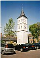
Catholic church, steeple
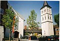
Catholic Church

Cologne-Merkenich, motorway exit A 1


literature
- Toni Jägers: Cologne-Worringen in history and stories. Self-published, Cologne 1985.
- Christian Schuh: Cologne's 85 districts. History, dates, facts, names. Emons , Cologne 2003, ISBN 3-89705-278-4 .
swell
Web links