Koenig-Heinrich-Platz (Duisburg)
| Koenig-Heinrich-Platz | |
|---|---|
| Place in Duisburg | |
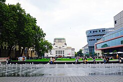
 König-Heinrich-Platz, view of the "floating" lawn, city theater and CityPalais with Mercator Hall |
|
| Basic data | |
| place | Duisburg |
| District | Old town |
| Hist. Names | Koenigsplatz |
| Buildings | Theater Duisburg, regional and district court building, Liebfrauenkirche, town house, Citypalais, Forum Duisburg |
| use | |
| User groups | Pedestrian traffic , underground parking |
| Technical specifications | |
| Square area | approx. 13,000 m² |
The King Henry Square is the central square of the Duisburg city center. It is located in Duisburg's old town and is one of the city's cultural centers.
location
The square, which has been freed from road traffic, is located in the Altstadt district north of Königstrasse, which is now a pedestrianized street . In the north it is bordered by Landfermannstraße with the Duisburg City Theater , the Duisburger Stadthaus and the Duisburger Hof, in the east by the City-Palais and in the west by the Duisburg Regional Court and the Church of Our Lady . Forum Duisburg is located south of the square . The course measures 160 meters in north-south direction and is 55 meters wide in west-east direction.
history
The name of the square goes back to King Heinrich I , who ruled from 919 to 936 and is said to have visited the city in 935 . An imperial synod was held under him in Duisburg in 929 .
Until 1908 there was a municipal cemetery on the site of the square at the gates of the medieval city. However, burials have not taken place since 1870 .
The Duisburg brothers Karl and Peter Strack tested their first self-designed and built "flying machine" on June 8, 1910 on the meadow hill north of today's square, the Strack I. Several flights of around 50 meters at a height of 3 meters were carried out. A plaque referring to this is located on the town house.
On November 16, 1887 , the performance of Carl Maria von Weber's “Preciosa” saw the inauguration of the Renaissance-style Tonhalle , a concert and theater building with a capacity of 1200 people, east of the cemetery .
The theater was operated as part of a theater community with Düsseldorf . The theater is also home to the orchestra founded in 1877 , today's Duisburg Philharmonic . To the west of the square, which was designed around 1912 and planted with chestnut trees, the building complex of the Duisburg regional court was built in three sections, from 1874 to 1876 , 1878 and between 1909 and 1912 .
In 1912 , the Duisburg City Theater was built north of the square, which had the most progressive stage equipment in Germany at the time and made Duisburg a center of musical life in western Germany.
On December 24th of the same year, the “square between the regional court, theater and concert hall” was named Königsplatz. On August 1, 1936 , it was renamed König-Heinrich-Platz.
The Tonhalle was completely destroyed in the hail of bombs during World War II in September 1942 . In its place, the simple and functional Mercatorhalle was built in 1962 , which was torn down in 2005 and replaced by the CityPalais, which opened in 2007 .
An underground parking garage was built below the square in the 1960s.
traffic
Today, König-Heinrich-Platz is integrated into the pedestrian zone of Königstrasse and completely without car traffic. Until the Mercatorhalle was built, there was a green area in the middle of the square that was used by cars on all sides. The eastern lane of the square was used by the tram. The central stop of the Duisburg trams was located south of the square until 1992. On July 11, 1992, the König-Heinrich-Platz underground station was opened there and the tram was moved underground. The platforms of the underground station are arranged on two levels in line operation.
A protective structure was built below the underground station with a total of 4,500 shelter spaces, spread over several levels. The shelters measure 250 meters in length and around 20 meters in height and width.
Individual evidence
- ↑ https://duisburg.city-map.de/02011100/ein-kurzer-ausflug-in-die-geschichte-von-duisburg A short excursion into the history of Duisburg
- ↑ http://www.bz-duisburg.de/Du_strassen_plz/Du_Ortsteile_strassennamengeschichte/Altstadt_K.htm
- ^ Walter Braun Verlag Duisburg, 1996: Brief history of the city of Duisburg , p. 39
- ↑ Gerd Brouwer: Duisburg - yesterday and today , p. 21, Mercator-Verlag Gert Wohlfarth, 1969
- ↑ Gerd Brouwer: Duisburg - yesterday and today , p. 18, Mercator-Verlag Gert Wohlfarth, 1969
- ^ Walter Braun Verlag Duisburg, 1996: Brief history of the city of Duisburg , pp. 247–248
- ↑ http://www.bz-duisburg.de/Du_strassen_plz/Du_Ortsteile_strassennamengeschichte/Altstadt_K.htm
Coordinates: 51 ° 26 ′ 0.8 ″ N , 6 ° 46 ′ 12.4 ″ E
