Cure
| Kure-shi 呉 市 |
||
|---|---|---|
|
|
||
| Geographical location in Japan | ||
| Region : | Chūgoku | |
| Prefecture : | Hiroshima | |
| Coordinates : | 34 ° 15 ' N , 132 ° 34' E | |
| Basic data | ||
| Surface: | 353.29 km² | |
| Residents : | 218,351 (June 1, 2019) |
|
| Population density : | 618 inhabitants per km² | |
| Community key : | 34202-5 | |
| Symbols | ||
| Flag / coat of arms: | ||
| Tree : | Oak | |
| Flower : | camellia | |
| town hall | ||
| Address : |
Kure City Hall 4 - 1 - 6 , Chuo Kure -shi Hiroshima 737-8501 |
|
| Website URL: | http://www.city.kure.hiroshima.jp/ | |
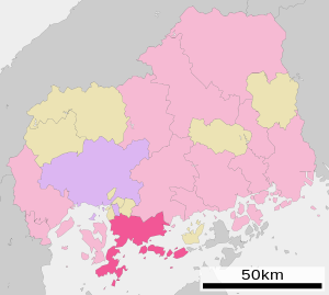
| Location Kures in Hiroshima Prefecture | ||
Kure ( Japanese 呉 市 , -shi ) is a city in Hiroshima Prefecture in the southwest of Honshū , the main island of Japan .
history
Kure is an old port city on the Seto Inland Sea . After 1868 the port also became a naval base . On October 1, 1902, the place was raised to a city.
Attractions
- Yamato Museum with a 1:10 scale model of the battleship Yamato .
- JMSDF Kure Museum of the Marine Self- Defense Forces with the Akishio submarine .
traffic
economy
In addition to mechanical engineering , shipyards and the steel and paper industry are also economically significant .
Before the Second World War , the city was one of the largest war ports in the Japanese Empire . The battleship Yamato was also built here. From 1952, the US engineer Daniel Keith Ludwig had the largest tankers in the world built at the naval shipyard.
Town twinning
sons and daughters of the town
- Yoshio Okada (1928–2008), physician and cell biologist
- Fusae Ōta (* 1951), politician and former governor of Ōsaka prefecture
- Akira Sakata (* 1945), jazz musician
- Hitomi Shimatani (* 1980), singer
- Masunaga Shizuto (1925–1981), Shiatsu practitioner
- Takayoshi Tanimoto (* 1975), singer
Neighboring cities and communities
Individual evidence
- ↑ Joachim W. Pein: Giants of the seas. The largest tankers in the world. Koehlers Verlagsgesellschaft, Hamburg 2011, pp. 9–13
- ↑ www.wenzhou.gov.cn: City friendships . Retrieved July 11, 2019.
Web links
Commons : Kure - collection of images, videos and audio files
- Yamato Museum (English)
- JMSDF Kure Museum (English)


