Calf (Meissner)
| Calf | ||
|---|---|---|
|
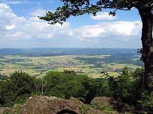
View from the calf to Berkatal - Frankershausen in the center of the picture |
||
| height | 719.5 m above sea level NHN | |
| location | at Vockerode ; Werra-Meißner-Kreis , North Hesse ( Germany ) | |
| Mountains |
Hoher Meißner in the East Hessian highlands |
|
| Coordinates | 51 ° 12 '59 " N , 9 ° 52' 25" E | |
|
|
||
| particularities | Good prospects from the “Kalbe” hilltop near the former “Kalbe opencast mine” | |

The calf near Vockerode in the Werra-Meißner district in northern Hesse is 719.5 m above sea level. NHN high basalt - summit of the Hoher Meißner mountain range .
geography
location
The calf rises in the northeast part of northern Hesse in the east of the massive Hohe Meißner in the geo-nature park Frau-Holle-Land (Werratal.Meißner.Kaufunger forest) . Its summit is about 2.3 km west-northwest of Vockerode , which, as a district of Meißner, is around 430 m lower than the Kalbengipfel with an average height of 290 m , and about 400 m (as the crow flies ) south-southeast of the Frau-Holle pond . The ice spring is located east below the Kalbe .
Natural allocation
The calf belongs to the natural spatial main unit group Osthessisches Bergland (No. 35), in the main unit Fulda-Werra-Bergland (357) and in the subunit Meißnergebiet (357.8) to the natural area Hoher Meißner (357.81).
Protected areas
Parts of the Meißner nature reserve ( CDDA no. 6969; designated in 1970; 9.32 km² in size) extend to the Kalbe summit region in the north, east and south . This also applies to those in the Fauna-Flora-Habitat- Area Meißner and Meißner-Vorland (FFH No. 4725-306; 20.42 km²). Parts of the Meißner bird sanctuary (FFH no. 4725-401; 37.2 km²) are located on the entire calf .
geology
The basalt dump is a block dump that can also be found in other parts of the Meißner, for example on the slope above the Frau Holle pond and behind the sea stones . It is the remainder of a cooled lava flow that was given its current shape due to the effects of the weather and which has for the most part still not been populated by vegetation, but is surrounded by forest.
history
Former open pit mine
In the "Kalbe opencast mine" located a few hundred meters southwest of the Kalbe hilltop, lignite was mined from 1949 to 1974 , which can still be seen on the site of the former opencast mine . After the pumps had been switched off, the open pit , whose quite evenly graduated and high basalt walls are impressive, the maximally 30 m deep and about 20,000 m² large "calf lake" formed, which was caused by the inflow of ground, surface and precipitation water originated. In 1977 the action “Save the Meissner” prevented the reopening of the opencast mine with great participation by the population.
In order to expose the mighty, 30 to 50 m thick coal seam , the overlying basalt masses had to be mined. The overburden was poured around the open pit on and over the mountain slopes. At the resulting heaps, which can be seen on the slopes of the calf, the basalt lumps pile up in steps.
Slipping of the calf
In 1964 an extraordinary event took place on the Kalbe during the open-cast coal mine. The rocks of the well-known heap threatened to slide off. The miners resorted to an emergency solution: they were to be held in place by means of thick stone blocks and 6 cm thick steel cables. After four months these ropes broke and many stone blocks fell into the depths. However, fears that the calf would slip completely were not confirmed. Today you can still see some of the stone blocks and a piece of one of the ropes on the calf.
Lookout point
The summit of the Kalbe is a good vantage point to the northeast, including over Vockerode , Frankershausen and the Werra valley to the Harz Mountains . A little below the summit, another lookout point allows a view to the southeast of the Thuringian Forest and the Rhön .
Transport links
The calf can be approached from Meißner-Vockerode - via the steeply ascending Landesstraße 3241 and in the Schwalbental northwards onto the "L 3242" in the direction of Kammerbach (western district of Bad Sooden-Allendorf ). It does not lead directly to the crest; However, this is starting at the hikers' parking lots in the area, for example at the Frau-Holle-Teich, on forest paths and paths on foot. The closest public transport stop is in Schwalbenthal.
Web links
References and comments
- ↑ a b c Map services of the Federal Agency for Nature Conservation ( information )
- ↑ a b What is interesting about block heaps is that air flows through them, which, depending on the season, leads to an exchange of cold and warm air flows with astonishing natural phenomena (e.g. at the ice spring east below the calf)
- ^ Hans-Jürgen Klink: Geographical land survey: The natural space units on sheet 112 Kassel. Federal Institute for Regional Studies, Bad Godesberg 1969. → Online map (PDF; 6.9 MB)
- ↑ Landespflege and Hoher Meissner: Statement by the German Council for Land Care on the open-cast mine on the Hoher Meissner and reports on dismantling and construction planning (= series of publications by the German Council for Land Care , volume 4) 1965, p. 19 (Fig. 7) online


