Pannonian Plain
Coordinates: 47 ° N , 19 ° E
The Pannonian Plain (also Pannonian Basin or Carpathian Basin ) is an extensive lowland plain in south- eastern Central Europe , which is crossed by the middle course of the Danube and the lower course of the Tisza . Most of the basin is in Hungary , but six other countries have a share in it. Geologically it is related to the (much smaller) Vienna Basin and the mountain formation of the Carpathian Arc. The lowlands are - separated by the Carpathians - the westernmost part of the Eurasian steppe belt , a large vegetation zone .
origin of the name
The term “Pannonia” was originally derived from the Roman province of Pannonia , which was geographically somewhat more extensive than the actual lowlands within this province. The name P. was also used for the region (or parts of the region) in post-Roman times . However, while the historical area west of the Danube comprised areas of Hungary as well as neighboring areas of Austria, Slovenia and Croatia, the term “Pannonian Plain” refers to the entire basin landscape within the Carpathian Arc. Hungarian geography therefore prefers the term “Carpathian Basin” ( Hungarian : Kárpát-medence), while most of the languages in the region use the term “Pannonian Plain”.
structure
It divides the Hungarian Central Uplands (near the Danube Bend ) into a smaller western part ( Small Hungarian Plain ) and a larger eastern part ( Great Hungarian Plain ), which morphologically includes the areas of Batschka , Srem and Banat bordering in the south . The Pannonian Plain extends from west to east over almost 400 kilometers; and from north to south it extends for almost 300 kilometers.
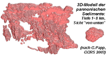
Geologically, the lowlands represent one of the large sedimentary basins in Europe, whose deposits, up to 8 km thick, were formed by the Paratethys in a subsidence period that lasted from the early Tertiary to the Pliocene . Mainly arose the basin fill in the Miocene - in the named Pannonia period Pannon before 5-10 million years ago, dried up as the sea, which had occupied this space before. The Pannonian Plain is surrounded by the mountain ranges of the Alps (eastern foothills), the Carpathian Mountains , the Balkan Mountains and the Dinaric Alps .
Politically, the Pannonian Plain today belongs to eight different states. It includes most of Hungary , the eastern edge of Austria (northern Burgenland with Seewinkel , edge of the Vienna Basin ), the southern lowlands of Slovakia (surroundings of Bratislava , the Danube Schüttinseln and the eastern Slovak lowlands around Košice ), the Kreisch area and the Banat im Western Romania , Syrmia and the Batschka in northern Serbia , the Slavonian (north) east of Croatia , the extreme northeast of Slovenia ( Prekmurje ) and the extreme west of Ukraine ( Zakarpattia Oblast ).
Hideaway
The Carpathian Mountains surrounding the eastern basin did not develop any permafrost soil during the last glacial period and were therefore able to preserve a densely wooded refuge for many animal and plant species native to Europe today . The preservation of many subspecies, along with the other two large refuges on the Iberian Peninsula and Italy, played an important role in the repopulation of Europe at the beginning of the Holocene and its resulting biodiversity .
See also
literature
- J. Breu: The atlas of the Danube countries of the Austrian Institute for East and Southeast Europe. In: MÖGG. Volume 109, Vienna 1967, p. 239ff.
- E. Gager: Border area East Austria-West Hungary. In: H. Hitz, H. Wohlschlägl (Ed.): Eastern Austria and neighboring regions. A geographic excursion guide. Böhlau, Vienna et al. 2009, ISBN 978-3-205-78447-0 , p. 531ff.
- Erich Hübl: Plant geography of the Pannonian area. In: Burgenland homeland sheets . Year 41, Issue 1, Eisenstadt 1979, pp. 1–14, PDF on ZOBODAT
- Norbert Krebs: The Eastern Alps and today's Austria . Vienna 1929.
- B. Molnar: Sediment geological investigations in Pliocene and Pleistocene deposits in the east of the Hungarian lowlands. In: Geologische Rundschau. Issue 12, 1964.
- R. Rungaldier: Cities and Landscapes of Pannonia. In: MÖGG. Volume 78, Vienna 1935, p. 178ff.
- HP Schönlaub: Explanations of the geological map of Burgenland. Edited by the Federal Geological Institute Vienna, 2000.
Individual evidence
- ↑ B. Molnar: Sediment geological investigations in Pliocene and Pleistocene deposits in the east of the Hungarian lowlands. 1964. (researchgate.net)
- ↑ Józef Mitka, Wojciech Baba, Kazimierz Szczepanek: Putative forest glacial refugia in the Western and Eastern Carpathians. In: Modern Phytomorphology. Volume 5, 2014, pp. 85-92.


