
Aquae Mattiacorum
Aquae Mattiacorum (also Aquae Mattiacae or Mattiacum ) is the name of the ancient Roman settlement in the city of Wiesbaden . A military presence in Wiesbaden opposite the Mogontiacum legionary camp ( Mainz ) has been assumed since the early Roman Empire . In the hinterland of the Limes , an important civil settlement developed in the 2nd century AD, which became the capital of the Civitas Mattiacorum . Civilians and soldiers valued Wiesbaden's warm healing springs, which is why the place had the addition of Aquae to its name . After the Romans retreated across the Rhine in the 3rd century, a military presence is still palpable in Wiesbaden, one of the most important remains of which is the so-called Heidenmauer .

history
The oldest Roman finds come from a layer of moor between Mauritiusstrasse, Hochstätte, Oberer Kirchgasse and Mauritiusplatz. The finds from the Wiesbaden moor layer ended with a horizon of destruction in Flavian times, probably as a result of the Batavian uprising in 69/70 AD, and go back to the Augustan period. It cannot be decided whether these finds come from a military camp or a civilian settlement, although the former is more likely on the right bank of the Rhine, which was largely unoccupied at the time. Emil Ritterling was able to prove several defensive trenches on the Heidenberg from the pre-Flavian times between 1899 and 1923, but they could not be reconstructed into a camp. Ritterling's excavation work was later continued by his successors Ferdinand Kutsch and Helmut Schoppa as head of the Nassau antiquities collection in the Wiesbaden Museum .
As the latest Wiesbaden fort, the stone fort was built on the Heidenberg in the 1980s following the Chatten War of Emperor Domitian . It was evacuated in the late Trajan or early Hadrian times when the troops were moved forward to the Limes, at the latest in AD 122. A similar process is taking place at many rear troop locations in the region, such as in Nida ( Frankfurt-Heddernheim ) or the forts Okarben and Groß- Rough to watch.
As early as the 1st century there was probably a civil settlement ( vicus ) in the vicinity of the forts . With the withdrawal of the troops, it became the administrative center of the surrounding civitas , which were named after the Germanic tribe of the Mattiakers . For the first time the name becomes tangible on a milestone found in Kastel , which indicates the distance from Aquae Mattiacorum and dates to the year 122 AD. Like the entire hinterland of the Limes, the place experienced an upswing in the 2nd and early 3rd centuries, which, in addition to its function as an administrative center, is primarily due to the healing springs. Important health resorts and baths were not uncommon in the Roman world, well-known examples in Germany are Baden-Baden (Aquae) or Badenweiler . Only with the fall of the Limes around 260 AD did the importance of the place decrease drastically.
Although several fire horizons from this period show partial destruction, coin finds point to a continuation of civilian settlement in the southern part of the vicus into the 4th century, including several coin treasures. In the second half of the 4th century, the pagan wall, the only Roman monument in Wiesbaden that is still visible today, was built, although it is not clear which fortification purpose it served.
Castles

The trenches proven by Ritterling on Platter Strasse are referred to as camps A, B and C; of all of them, only parts of the trench are present, from what is probably the oldest camp A there is also a gate area with a protective trench (tutulus) in front . Finds indicate that camp B dates back to the pre-Flavian period, while camp C possibly preceded the stone fort in the period after the Batavian uprising in 69/70 AD.
The main buildings inside the 2.2 hectare stone fort on the Heidenberg were excavated, including the commandant's apartment (praetorium) , a military hospital (valetudinarium) , two storage buildings (horrea) and the staff building (principia) . After the troops withdrew, the commandant's house was converted into a workshop (fabrica) . There were two pointed ditches in front of the wall as an obstacle to the approach.

Some soldiers' gravestones from the time of Wiesbaden's fort give evidence of the troops stationed here. These are the oldest monuments of their kind to the right of the Rhine. Soldiers of the Cohors V Delmatarum , Cohors I Pannoniorum and Cohors IIII Thracum died during their service time , although it cannot be said when and in what order the troops were stationed in Wiesbaden. Much more sources are available for the Cohors II Raetorum civium Romanorum , which probably formed the occupation of the stone fort. Two soldiers from this cohort died during their service in Wiesbaden. A military diploma that was found in the area of the stone fort also identifies this troop. The second raider cohort was relocated to the Butzbach fort in Wetterau around 90 AD . The Cohors III Delmatarum could have followed you for a short time as crew of the stone fort, of which there are several brick stamps. This is later documented as the occupation of Rückingen Fort .
Thermal baths


The erection of the fort in the Wiesbaden urban area probably not only served to monitor the Taunus ridge. Already in the 1st century the thermal baths started to operate briskly , as can be deduced from building work and the related finds of early brick temples of the Legio XXII Primigenia from neighboring Mainz. Already Pliny the Elder mentioned the Wiesbaden Hot Springs. The poet Martial calls the Wiesbaden source sinter as a hair dye.
A total of three thermal bath complexes can be found in Wiesbaden, of which the thermal baths at Kranzplatz south of the Kochbrunnen are best explored. They have two larger pools and several smaller tubs in the vicinity. A larger building southeast of it is interpreted as a hostel (mansio) . In the vicinity of the Adlerquelle, another thermal bath system was discovered between Coulinstrasse and Langgasse, which had a large rotunda (presumably a Laconicum ) and three adjacent long rectangular buildings.
Little is known about the thermal baths on Schützenhofstrasse, of which there are a number of inscriptions. In any case, it was not a common fort bath, although several inscriptions indicate a state or military use. Soldier gravestones from units such as the Ala I Scubulorum or the Ala I Flavia , which were never stationed in Wiesbaden, prove this. Lead pipes with inscriptions from the Legio XIIII Gemina led the water from a contained spring into the bath. Another indication of the spa business is the consecration of Antonia Postuma, wife of the legionary legate of Mainz, Titus Porcius Rufianus, who donated a statue as thanks for the healing of her daughter Diana Mattiaca .
Civil settlement
The civil settlement initially developed under the protection of the forts in the area southeast of the stone fort. The building boundary ran roughly along Schwalbacher Strasse to Kochbrunnen, from there to the southeast to Mühlgasse, and in the south the vicus extended to the south of Maurergasse. A reference to the arterial roads of the fort is not recognizable.
The place itself had like many main Civitas places that did not reach the status of a Colonia or a Municipium , the status of a Vicus, as can be seen from an inscription from the year 194 AD, which mentions the inhabitants as vicani Aquenses . Another inscription calls a praefectus aque (nsium) and also refers to the self-designation of the inhabitants as Aquenses , which is common from all other places with the name Aquae . In addition to their status as the administrative center, the thermal baths are likely to have made up a substantial part of the economic basis, about which little is otherwise known. One inscription names a meeting house of the dealers (schola der negotiatores civitatis Mattiacorum) , another one names a ceramic dealer (negotiator artis cretariae) .
The only known sanctuary in the city is a mithraeum , which was found near Coulin Street in 1902. The cult room was partially built into the eastern slope of the Schulberg. It had side podiums as benches, a niche for the cult image and a sacrificial pit in the middle of the room. The Mithraeum was built in the 3rd century and removed around 360 AD to build the pagan wall. Other sanctuaries for Iupiter Dolichenus and the Celtic goddess Sirona can only be identified through inscriptions.
Late antiquity

In late antiquity , the remaining settlement was concentrated in the southern vicus area between Mauritiusplatz and Friedrichstrasse. The function of the so-called Heidenmauer , which ran north of it in the direction of WNW-OSO, is not fully understood . It consisted of a cast masonry with a foundation width of three meters and can be traced over a length of 520 m, but only preserved over a length of about 80 m. At least four towers can be identified, one of which is still preserved. The function of the wall is unclear because there were no corresponding defensive walls on the other sides of the settlement. Ritterling suspected that it was a barrier wall (clausura) in the foreland of the Mainz legion camp. More recently, it is more likely that the wall remained unfinished as a whole. The construction of the wall was apparently very hasty, as there were a lot of different stone materials, including spoils from stone monuments from the Middle Imperial period, e.g. B. column capitals were used. In the surrounding area and directly in the masonry there are brick finds with the stamps of late Roman military units. The Martenses , Vindices , Secundani and Portissenses belonged to the Mainz command district.
In 1902 the heath wall was broken through to build Coulinstraße and the opening was supplemented by a number of romanized additions. Copies of some Roman stone monuments have been placed below the Roman gate that was created in this way.
Copies of stone monuments from the Nassau antiquities collection
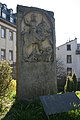
Gravestone of the rider Dolanus Bessus: "Dolanus Bessus, son of Esbenius, rider of the 4th Thracian cohort, 46 years old, 24 years of service, is buried here."

Building inscription for a meeting house of local traders

Inscription for the restoration of a Dolichenus sanctuary


See also
literature
- Friedrich Gustav Habel : The Römer-Castell near Wiesbaden . In: Nassauische Annalen 3, 1842, pp. 131–158.
- Maximilian Him : Aquae Mattiacae. In: Paulys Realencyclopadie der classischen Antiquity Science (RE). Volume II, 1, Stuttgart 1895, Col. 302.
- Emil Ritterling , Ludwig Pallat : Roman finds from Wiesbaden. In: Annals of the Association for Nassau antiquity and historical research 29, 1897/98, pp. 115–169.
- Emil Ritterling: The Wiesbaden Castle. In: Ernst Fabricius , Felix Hettner , Oscar von Sarwey (ed.): The Upper Germanic-Raetian Limes of the Roemerreiches Dept. B 2,3b No. 31 (1909).
- Helmut Schoppa : Aquae Mattiacorum and Civitas Mattiacorum. In: Bonner Jahrbücher 172, 1972, pp. 228–237.
- Helmut Schoppa: Aquae Mattiacae. Wiesbaden's Roman and Alemannic-Merovingian past. Steiner, Wiesbaden 1974.
- Hans-Günther Simon : Wiesbaden. WI. Fortresses and Civitas capital Aquae Mattiacorum. In: Dietwulf Baatz , Fritz-Rudolf Herrmann (Hrsg.): The Romans in Hessen . Theiss, Stuttgart 1989 (licensed edition 1989, Nikol, Hamburg 2002, ISBN 3-933203-58-9 ), pp. 485-492.
- Walter Czysz : Wiesbaden in Roman times. Theiss, Stuttgart 1994, ISBN 3-8062-1088-8 .
- Karlheinz Dietz : Aquae [III 4, Mattiacae]. In: The New Pauly (DNP). Volume 1, Metzler, Stuttgart 1996, ISBN 3-476-01471-1 , column 929 f.
- Armin Becker : Mattiacum. In: Reallexikon der Germanischen Altertumskunde (RGA). 2nd Edition. Volume 19, Walter de Gruyter, Berlin / New York 2001, ISBN 3-11-017163-5 , pp. 440–443.
Individual evidence
- ↑ Hans Ulrich Nuber : A stratigraphic exposure in the area of the "Wiesbadener Moorschicht" . In: Find reports from Hessen . 19/20, 1979/80, pp. 645-677; Gabriele Seitz: New stratigraphic outcrops in the Wiesbaden peat layer. In: Preservation of monuments in Hessen. 1/1988 ( online ).
- ↑ CIL 13,9124 .
- ↑ For the castles see Emil Ritterling: Das Kastell Wiesbaden. In: Ernst Fabricius , Felix Hettner , Oscar von Sarwey (ed.): The Upper Germanic-Raetian Limes of the Roemerreiches Dept. B 2,3b No. 31 (1909).
- ↑ CIL 13, 7581 .
- ↑ CIL 13, 7582 .
- ↑ CIL 13, 7585 .
- ↑ CIL 13, 7583 ; CIL 13, 7584 .
- ↑ CIL 16, 62 .
- ↑ Pliny, Naturalis historia 31, 20 : sunt et Mattiaci in Germania fontes calidi trans Rhenum .
- ↑ Martial, Epigrammata 14, 27 .
- ↑ CIL 13, 7580 ; CIL 13, 7579 .
- ↑ CIL 13, 7565 .
- ↑ a b CIL 13, 07566a .
- ↑ CIL 13, 7279
- ↑ Werner Eck : A praefectus Aquen (sium), no praefectus aqu (a) e. To the inscription CIL XIII 7279 from Mainz-Kastel. In: Nassauische Annalen 125, 2014, pp. 21–28, here: p. 26.
- ↑ CIL 13, 7587 .
- ↑ CIL 13, 7588 .
- ↑ CIL 13, 7570 .
- ↑ H.-G. Simon in Baatz / Herrmann 1989, p. 491; H. Schoppa: Aquae Mattiacorum and Civitas Mattiacorum. In: Bonner Jahrbücher. 172, 1972, p. 232.
- ^ Walter Czysz: Wiesbaden in Roman times. Theiss, Stuttgart 1994, p. 224.

Andernach Castle (Antunnacum) | Koblenz Castle (Confluentes) | Kesselstadt Castle | Fort Heldenbergen | Fort Okarben | Friedberg Castle | Fort Nida-Heddernheim | Fort Frankfurt am Main - Domhügel | Höchst Castle | Hofheim Castle | Heidekringen small fort | Legion camp Mainz | Wiesbaden Castle | Fort Mainz-Kastel | Bingen Castle (Bingium) | Groß-Gerau fort | Fort Gernsheim | Small fort Allmendfeld | Fort Worms (Borbetomagus) | Forts of Ladenburg (Lopodunum) | Forts of Heidelberg | Rheingönheim Castle | Eislingen-Salach Castle | Strasbourg legionary camp (Argentoratum) | Castles of Offenburg | Castles of Sasbach | Castles of Riegel | Fort Biesheim (Argentovaria) | Roman camp Untereggingen | Dangstetten Roman Camp | Legion camp Windisch (Vindonissa)
Coordinates: 50 ° 5 ' N , 8 ° 14' E