Klieversberg (district)
|
Klieversberg
City of Wolfsburg
Coordinates: 52 ° 24 ′ 59 ″ N , 10 ° 46 ′ 10 ″ E
|
|
|---|---|
| Residents : | 1085 (December 31, 2015) |
| Postal code : | 38440 |
| Area code : | 05361 |
|
Location in Wolfsburg
|
|
Klieversberg is a district of Wolfsburg , southwest of the city center, right next to the city forest. It is located on the Klieversberg hill of the same name , which at 110 meters is the highest point in Wolfsburg's core city.
history
Before 1938 - the year the city was founded - the Klieversberg, also known as Kliebersberg in earlier times, was only sparsely developed. There was a quarry that was closed in 1925 (now an animal enclosure), a forester's house and a sheepfold (both of which have since been demolished). A deserted, fallen village called Klieverde (also Cliverde) is suspected to be in its vicinity. The country road from Wolfsburg to Mörse also led over the Klieversberg . With the opening of Braunschweiger Strasse in 1951, the old street lost its importance; today it still exists between the Scharoun Theater and the Center for Developmental Diagnostics and Social Pediatrics (ZEUS) at the hospital.
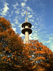
When the “City of the KdF-Wagons” - later Wolfsburg - was planned in the 1930s, a “town crown” consisting of party buildings was planned on the Klieversberg according to the “ Koller Plan ”. These plans were not implemented due to the war. Around 1938, a wooden surveying tower was erected as a trigonometric point in the area of today's memorial, and it was demolished again during the war. The Porsche hut was also built around 1938. From 1938 on, an elevated tank was built near the former quarry , which ensured the water supply for the Volkswagen factory and the city. In 1943 it was replaced by a larger elevated water tank near Nordsteimke . Later it was only kept as an emergency container, but has since been shut down.
In 1953 the memorial of the expellees was inaugurated, before that there was already a cross made of birch trunks. In 1954 the Grün-Gold tennis club opened its tennis facility with a clubhouse. Housing construction began in 1955, and the Wolfsburg City Clinic has also been located there since 1955. The southern part of the settlement was designed as a garden city . In 1958/59 the animal enclosure was created. The Hotel Europa was built around 1960 , today the Hotel am Klieversberg . The Evangelical Reformed Church was opened in 1961 and the Holy Spirit Church was consecrated in 1962 . The particularly in the post-war popular Waldpavillon, popularly known as "Café mosquito bite", burned in 1970 and was not rebuilt. In the 1970s, the Klieversberg was enriched by a fitness trail , and in 1976 the telecommunications tower was built. In 1982, the Porschehütte, which had previously been vacant for around 15 years, was taken over by an artist couple who, after renovation , opened a gallery in the building two years later . In 2006 a development association took over the sponsorship of the previously municipal animal enclosure. In 2012 the gallery moved from the Porschehütte to the neighboring new building.
politics
Together with the neighboring districts of Eichelkamp , Hageberg , Hohenstein , Laagberg , Rabenberg and Wohltberg, Klieversberg forms the town of Mitte-West , which is represented by a local council. The local mayor is Matthias Presia ( SPD ).
Attractions
- Animal enclosure (in the former limestone quarry at the clinic)
- Memorial to the expellees. 14 m high memorial, laying of the foundation stone in 1950, inauguration on the Sunday of the Dead in 1953. Before that there was a simple cross made of birch trunks. In 1961 the coats of arms of the East German country teams were added. From there a good view of part of the city and the Volkswagen factory .
- Porschehütte ( Ferdinand Porsche's place of residence and work during his stay in the city of the KdF car )
- Gallery of the artist group Porschehütte
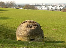
- One-man bunker from World War II near the memorial
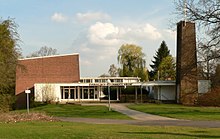
- Rotary building of the clubhouse at the tennis courts (built in 1954)
Art in the cityscape
- Wall mosaic by Rudolf Mauke (Wolfsburg) - Clinic
- Study for Third Watcher (1959) by Reginald Butler (Berghamstedt) - Klinikum
- Figure to the left - Relief (1964) by Andreas Judgment (Vienna) - Clinic
- The first step (1967) by Jürgen Weber - Klinikum
- Ceramic wall relief (1968) by Rudolf Mauke (Wolfsburg) - Klinikum
- Give me my ball (1980) by Harald Isenstein (Copenhagen) - Klinikum (a model of which is on the St. Petrus Church in the Vorsfelde district )
Churches
- Holy Spirit Church (built in 1961/62 by Alvar Aalto ) - Evangelical Lutheran
- Evangelical Reformed Church. In 1958 the Evangelical Reformed parish was founded, and from 1959 to 1961 the church on Sauerbruchstrasse, designed by Hans-Joachim Valentin, was built. Today (2017) the parish, which in addition to Wolfsburg also includes Gifhorn , Helmstedt and Peine , has around 1,300 members.
literature
- Paul Metzner: The Klieversberg. In: Wolfsburg - our city. Wolfsburg 1963, pp. 62-64.
- Wilhelm Spennemann: The shepherd's fountain on Klieversberg. In: Wolfsburg - our city. Wolfsburg 1963, pp. 104/105.
- Fritz Hesse: Wolfsburg, yesterday and today. 2nd edition, Wolfsburg 1968, pp. 3-4.
- Nicole Froberg, Ulrich Knufinke, Susanne Kreykenboom: Wolfsburg. The architecture guide. 1st edition 2011, ISBN 978-3-03768-055-1 . Pp. 70, 89, 104/105.
Web links
Individual evidence
- ↑ cartography. Department of the Deputy General Staff of the Army (Ed.): Map of the area around Braunschweig and Wolfenbüttel. 1916.
- ^ Paul Metzner: The Klieversberg. In: Wolfsburg - our city. Wolfsburg 1963. p. 63
- ^ City of Wolfsburg (ed.): Wolfsburg 1938–1988. Wolfsburg 1988. p. 40.
- ^ Eva-Maria Bast: Water on the way from Klieversberg to the city. In: Wolfsburger Nachrichten. Friday Packet for March 13, 2018.
- ↑ Hans Karweik: Research and convey art. Dietlinde and Bernhard Zimbelmann have been making art in the Porschehütte on the Klieversberg for 35 years. In: Wolfsburger Nachrichten. Friday Packet for July 26, 2017.
- ↑ Friends of the animal enclosure
- ↑ Porschehütte artist group
- ^ Ernst Pauer: Church history and church art. In: Historical-regional excursion map of Lower Saxony, sheet Wolfsburg. Erhard Kühlhorn, Hildesheim 1977, ISBN 3-7848-3626-7 , explanatory booklet p. 116.
- ↑ Evangelical Reformed Church Parish Wolfsburg-Gifhorn-Peine ( Memento of the original from February 23, 2017 in the Internet Archive ) Info: The archive link was inserted automatically and has not yet been checked. Please check the original and archive link according to the instructions and then remove this notice.


