
Commos

Kommos ( Greek Κομμός or Κομός ( m. Sg. )) Refers to an archaeological excavation site on the south coast of the Greek island of Crete . It is located in the municipality of Festos in the Heraklion regional district on the southwestern edge of the Messara plain . It is suspected that Kommos is the ancient Cretan city of Amyklaion ( ancient Greek Ἀμύϰλαιον , also Άμυκλαῖον ), but has not been proven.
location
The excavation site of Kommos is located six kilometers south of the main town of the municipality, Tymbaki (Τυμπάκι), on the beach of Komos on the Libyan Sea . The beach forms the southern section of the coast of the Messara plain on its west side, on the Bay of Messara (Όρμος Μεσαράς). The nearest towns are Kalamaki (Καλαμάκι) 1.5 kilometers north, Pitsidia (Πιτσίδια) 2 kilometers east and Matala (Μάταλα) 2.5 kilometers in the southwest. Kommos can be reached on an asphalt road from Pitsidia. In the south, with the 391 meter high Kefali (Κεφάλι), the western foothills of the Asterousia ridge (Αστερούσια όρη) stretch to Cape Lithino (Ακρωτήριο Λίθινο) and shield the Messara plain from the south coast. The larger archaeological sites of ancient cities and palaces in the Messara plain are all northeast of Kommos, Agia Triada 5.75 kilometers, Phaistos 6.25 kilometers and Gortyn 18 kilometers away.
history
The Messara Plain has been around since the Neolithic Age , around 6500 BC. Settled . During the time of the Minoan civilization , they were built here between 1900 and 1450 BC. Cities with extensive palace complexes. The most important places in the Messara were Phaistos and later Gortyn. In addition to agriculture, trade was an important branch of the economy in the cities of that time. This took place largely over the sea, which required port facilities near the major economic centers.


Archaeological evidence shows that a settlement on the southwest coast of the Messara plain, now known as Kommos, began around 1900 BC. Has existed. It can be assumed that the port was built because Phaistos and later Agia Triada lost direct access to the sea due to the landing process of the Mires and Timbaki basins at the mouth of the Geropotamos (Γεροπόταμος). Kommos existed as a Minoan port city until 1200 BC. BC, the time of the " sea peoples storm " in the eastern Mediterranean, and later as a Greek settlement until the time of the Roman Empire . It was abandoned around 200 AD. Variously been suggested that near Kommos in the Odyssey of Homer mentioned "smooth rocks" (λισσὴ πέτρη Lisse Petre was) on which most of the fleet of Menelaus when returning from Troy to be crashed during a storm. It could be Cape Lithino or the Paximadia Islands . In the Odyssey it says in the third song, lines 293 to 298 (in the translation by Johann Heinrich Voss ):
At the Gordynian frontier, in the dark billowing sea,
a smooth rock towers against the urgent floods,
which the mighty south storms on the left mountain before
Phaestus; and the little rock restrains great surging waters.
Most of them came there; and scarcely escaped destruction,
nor the men, the ships, the surf smashed against the cliffs.
Around 1700 BC Destroyed by a major earthquake in BC , the settlement of Kommos is considered the port of Phaistos or Agia Triada after the immediate reconstruction. Until 1200 BC The built-up area expanded to the north and east beyond the fencing of the current excavation site. For 1200 to 1000 BC There are no signs of settlement, so there is a possibility of abandoning the city during this period. Archaeological finds such as ceramics and sculptures have shown connections from Kommos to Sardinia , Lower Italy , Egypt , Cyprus and the Levant . A Phoenician shrine from around 800 BC is likely to be of particular interest . BC, which was found in Temple B by Kommos. Along with a similar shrine at Prinias (near Rhizenia ), it is one of only two of its kind in the Aegean Sea .
In 1924, the excavator of Knossos , the British archaeologist Arthur Evans , first heard of the Kommos site due to antique storage vessels from there and speculated about a Bronze Age "Customs House" ( customs house , export building) at this location. But until the beginning of the 1970s, experts assumed a possible settlement near Kokkinos Pyrgos (Κόκκινος Πύργος) northwest of Tymbaki as the port of the Minoan center Phaistos. The German amateur archaeologist Friedhelm Will , on the other hand, argued in favor of Kommos as a port facility and tried to prove this by forbidden digs in the dunes behind the beach. There he came across the first remains of the wall of today's excavation site, but had to be held in Greek custody according to a complaint .
Since 1976, official excavations have been carried out in Kommos with the permission of the Greek Archaeological Service . The research by a team of archaeologists from the University of Toronto , supported by the American School of Classical Studies in Athens , was directed by Joseph Winterbothams Shaw and Maria Coutroubaki Shaw . From 1990 to 2006 a five-part description (in seven volumes) of the excavation results was published by Princeton University . After the actual excavations were completed, consolidation work was carried out from 2004 to 2006 to protect against erosion. An intended opening of the site for viewing by the general public has not yet been implemented.
description


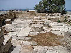
The excavation site of Kommos is divided into three nearby excavation areas, which are located on the south side of the small hill Stou Spanou ta Kephalia . They pull themselves up the hill parallel to the coast. At the foot of the hill, in the south, is the largest excavation field with the foundations of the "Greek temple", which was built on the walls of a Minoan palace, and the remains of boat sheds from the late Minoan period. Here was the center of the Minoan port city.
The middle area, 20 meters north on the slope of the hill, is the smallest of the three excavation fields. The remains of the buildings there date from the old and new palace periods . Here you can see that the houses of the new palace period were built on the ruins of the older buildings. The third excavation field extends to the top of the hill, 40 meters north of the central area. There are remains from the post-palace period , the time of the greatest expansion of the urban area. Stairs were found in many of the houses, which indicates a two-story construction.
The most numerous finds were made in the southern excavation field. Here the remains of the building are positioned around a courtyard, the central square of the Minoan city. The few oldest remains come from the pre-palace period . Much larger parts from the New Palace period (Middle Minoan III) and the post-palace period (Late Minoan IA to III) have been preserved, including the foundation walls of a small palace complex and six elongated structures, which are believed to have served as sheds for sheltering and repairing ships. A remarkable find comes from a house on the northeast side of the area, House X, the remains of a fresco with white lilies. The Minoan settlement structures were later built over by other buildings in geometric , archaic and classical times.
The post-Minoan temple area is located on the northwest side of the southern excavation area. The first establishment of a sanctuary there (Temple A) took place in the late 11th century BC. Chr. , V around 1020. BC, built from stone blocks from the former Minoan city. Temple A was built around 800 BC. Replaced by Temple B, which lasted until 600 BC. Was in use. In it, the excavators found a shrine with three stone pillars in a block of the floor, which was identified as Phoenician. Other finds in this area were Cretan terracotta figures, a small Greek bronze horse, Egyptian faience figures of the goddess Sachmet and her son Nefertem, as well as weapons that probably belonged to a local elite warrior class.
Most of the artefacts that lay in the various layers of the earth in Kommos were pottery from the most diverse eras and areas of the eastern Mediterranean. In addition to pithoi , krateres , aryballoi , jugs and cups from the Middle and Late Minoan, Protogeometric and Geometric periods, this includes vessels and pottery remains from Cyprus, Egypt, the Levant and Sardinia. Clay was also produced in the settlement . From the environment of a ceramic kiln comes about 450 kg Tongutscherben, especially false fires . Household items and furnishings were also found, as well as tools and installations for an oil press.
- Archaeological site of Kommos

Southern excavations

View towards the main courtyard
Greek temple C

Detail of the building remains


literature
- RGV Hancock, PP Betancourt: INAA of Minoan ceramics from Kommos, Crete . Journal of Radioanalytical and Nuclear Chemistry 114/2, 1987.
- P. Betancourt, L. Berkowitz, RL Zaslow: Evidence for a Minoan basket from Kommos, Crete . Cretan Studies 2, 1990, pp. 73-77 .
- Joseph W. Shaw: The Phoenician shrine in Kommos on Crete (approx. 800 BC) . Publications of the Joachim Jungius Society Wiss. Hamburg 87, 1998, p. 93-104 . (Hans Niemeier Festschrift)
- Joseph W. Shaw, Peter M. Day, Vassilis Kilikoglou: A LM Ia Ceramic Kiln in South Central Crete . The American School of Classical Studies at Athens, Athens 2001, ISBN 0-87661-530-2 .
- Joseph W. Shaw: Kommos: A Minoan Harbor Town and Greek Sanctuary in Southern Crete . The American School of Classical Studies at Athens, 2006, ISBN 0-87661-659-7 .
- Esther Widmann: The Archeology of the Household in the Cretan New Palace period . Master thesis. Ruprecht-Karls-Universität Heidelberg, Heidelberg 2007, Kommos, p. 41–48 ( digitized version [PDF; 23.6 MB ; accessed on February 7, 2018]).
Individual evidence
- ^ Paulys Realencyclopadie der classischen Antiquity Science (Pauly-Wissowa), p. I, 0071
- ↑ Angelos Chaniotis : The Treaties between Cretan Poleis in the Hellenistic Period . Franz Steiner Verlag, Stuttgart 1996, ISBN 3-515-06827-9 , pp. 394 ff .
- ↑ a b c d e Kommos Excavations, Crete - Introduction: Kommos and the Mesara. www.fineart.utoronto.ca, accessed July 24, 2010 .
- ↑ Thomas Guttandin, Diamantis Panagiotopoulos, Hermann Pflug, Gerhard Plath: The ports of Minos . In search of the foundations of Minoan maritime power. In: Ancient World . Journal of Archeology and Cultural History. No. 2/2014 . Philipp von Zabern , Darmstadt 2014, Die Hafenstätte Kommos, p. 19-21 .
- ↑ a b Andonis Vasilakis: Agia Triada, Phaistos, Kommos - Matala . Verlag Mystis, Iraklio 2009, ISBN 978-960-6655-58-6 , p. 103 .
- ↑ Homer : Odyssey in the Gutenberg-DE project
- ↑ ΟΔΥΣΣΕΙΑΣ - τὰ ἐν Πύλῳ (ancient Greek original of the 3rd song of the Odyssey). www.gottwein.de, accessed on July 31, 2010 .
- ^ Lambert Schneider : Crete . DuMont Reiseverlag, Ostfildern 2006, ISBN 978-3-7701-3801-2 , p. 173 .
- ↑ a b Kommos Excavations, Crete - The Greek Sanctuary. www.fineart.utoronto.ca, accessed July 24, 2010 .
- ↑ Dario Palermo: Diario minimo d'archeologia. La Missione dell'Università di Catania a Creta. (Italian). www.bda.unict.it/, accessed on November 2, 2015 .
- ↑ Eberhard Fohrer: Crete . Michael Müller Verlag, Erlangen 2009, ISBN 978-3-89953-453-5 , p. 361 .
- ^ Kommos Excavations, Crete - Kommos Publications. www.fineart.utoronto.ca, accessed July 27, 2010 .
- ^ Kommos Excavations, Crete - Kommos Site Plan, All Periods. www.fineart.utoronto.ca, accessed August 3, 2010 .
- ^ Kommos Excavations, Crete - Minoan Palace & Shipsheds. www.fineart.utoronto.ca, accessed August 3, 2010 .
- ↑ a b Andonis Vasilakis: Agia Triada, Phaistos, Kommos - Matala . Verlag Mystis, Iraklio 2009, ISBN 978-960-6655-58-6 , p. 104 .
- ^ Kommos Excavations, Crete - Minoan Town. www.fineart.utoronto.ca, accessed August 3, 2010 .
- ^ Kommos Excavations, Crete - Southern Area Period Plan. www.fineart.utoronto.ca, accessed July 29, 2010 .
- ^ Kommos Excavations, Crete - Minoan & Greek Pottery. www.fineart.utoronto.ca, accessed August 3, 2010 .
- ^ Livingston Vance Watrous: Kommos III, The Late Bronze Age Pottery. Princeton University Press, Princeton NJ 1992, ISBN 978-0-691-03607-6 , pp. 163-191, plates 56-57
Web links
- Commos. Minoan Crete, July 12, 2015, accessed January 9, 2017 .
- Kommos Excavations, Crete (English)
- Kommos Conservancy (English)
Coordinates: 35 ° 0 ′ 48 ″ N , 24 ° 45 ′ 39 ″ E