
Kossèye (Niamey I)
Location of Kossèye in Niger |


Kossèye (also: Kossey ) is a village in the Arrondissement Niamey I of the city of Niamey in Niger .
The village, led by a traditional chief (chef traditionnel) , is located on the Niger River in the west of the rural area of Niamey I. The surrounding settlements include the village of Gabou Goura in the northwest and the district of Losso Goungou in the east.
The place name refers to the plant species Piliostigma reticulatum in the Zarma language .
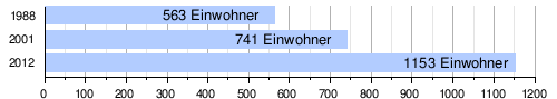
At the 2012 census, Kossèye had 1153 inhabitants who lived in 178 households. At the 2001 census, the population was 741 in 119 households, and at the 1988 census, the population was 563 in 72 households.
The public primary school Ecole primaire de Kossèye was founded in 1977. There is a simple health center (case de santé) in the village , which was set up in August 2004 and later refurbished by the US aid organization Mercy Corps .
Web links
Individual evidence
- ↑ a b National Repertoire des Localités (ReNaLoc). (RAR) Institut National de la Statistique de la République du Niger, July 2014, p. 715 , accessed on August 7, 2015 (French).
- ↑ Harouna Mounkaila: Espace frontalier et appropriations territoriales: jeux et enjeux autour de l'île de Lété (Niger) . In: Les Cahiers d'Outre-Mer . No. 249 , 2010, p. 126 ( journals.openedition.org [accessed June 3, 2019]).
- ^ Répertoire National des Communes (RENACOM). (RAR) (No longer available online.) Institut National de la Statistique de la République du Niger, archived from the original on January 9, 2017 ; Retrieved November 8, 2010 (French). Info: The archive link was inserted automatically and has not yet been checked. Please check the original and archive link according to the instructions and then remove this notice.
- ↑ Recensement Général de la Population 1988: Répertoire National des Villages du Niger . Bureau Central de Recensement, Ministère du Plan, République du Niger, Niamey March 1991, p. 222 ( web.archive.org [PDF; accessed May 4, 2019]).
- ↑ Daniel Barreteau, Ali Daouda: Systèmes éducatifs et multilinguisme au Niger. Results scolaires, double flux . Orstom / Université Abdou Moumouni de Niamey, Paris / Niamey 1997, ISBN 2-7099-1365-8 , p. 85 ( horizon.documentation.ird.fr [PDF; accessed May 29, 2019]).
- ^ Hassane Daouda: Visite du ministre de la Santé Publique dans des unités de soins de trois arrondissements de la région de Niamey: Recensement desproblemèmes des formations sanitaires au menu de la visite. In: Niger Diaspora. November 1, 2011, accessed May 27, 2019 (French).
Coordinates: 13 ° 32 ' N , 2 ° 2' E