Łambinowice
| Łambinowice Lamsdorf |
||
|---|---|---|

|
|
|
| Basic data | ||
| State : | Poland | |
| Voivodeship : | Opole | |
| Powiat : | Nysa | |
| Gmina : | Łambinowice | |
| Area : | 24.55 km² | |
| Geographic location : | 50 ° 32 ' N , 17 ° 33' E | |
| Height : | 200-210 m npm | |
| Residents : | 2303 (January 3, 2019) | |
| Postal code : | 48-316 | |
| Telephone code : | (+48) 77 | |
| License plate : | ONY | |
| Economy and Transport | ||
| Rail route : | Opole – Nysa | |
| Next international airport : | Katowice | |
The Łambinowice ( German Lamsdorf , also Lammsdorf ) is a Schulzenamt in the powiat Nyski (Nysa district) . It belongs to the Opole Voivodeship in the south-western part of Poland . It is the municipal seat of the rural community Gmina Łambinowice . The village gained historical importance through the prisoner-of-war camp Stalag VIII B (344) Lamsdorf .
geography
Geographical location
Łambinowice is located in the southwestern part of Upper Silesia in the Falkenberger Land. The village of Łambinowice is located about 20 kilometers northeast of the district town of Nysa (Neisse) and about 35 kilometers southwest of the voivodeship capital Opole .
Budzieszowice is located in the Nizina Śląska (Silesian Plain) within the Równina Niemodlińska (Falkenberg Plain) . The place is on the Opole – Nysa railway line . To the north and east of the village there are extensive forest areas that belong to Fort Tillowitz.
Neighboring places
Neighboring towns of Łambinowice are in the north Szadurczyce (Schader joke) , in the southeast Wierzbie (Wackenau) , in the southwest Budzieszowice (Bausch joke) as well as in the northwest Bielice (Bielsko) and Okopy (cold corner) .
history
The village was first mentioned as Lambinowicz in 1273 . In 1335 the village was mentioned as Lamberti and in 1536 as Glombinowicz .
During the Thirty Years War the village was looted and destroyed.
After the First Silesian War in 1742, Lamsdorf and most of Silesia fell to Prussia . Between 1743 and 1817 the village belonged to the Neisse district .
After the reorganization of the province of Silesia , the rural community of Lamsdorf belonged to the district of Falkenberg OS in the administrative district of Opole from 1817 . In 1845 there was a Catholic church, a Catholic school, two outbuildings and 88 houses in the village. In the same year 540 people lived in Lamsdorf, 6 of them Protestants. In 1855 580 people lived in the village. In 1861 Lamsdorf again had 603 inhabitants. From 1864, the Prussian Army at Lamsdorf for the VI. Army Corps to a military training area , which mainly used its foot artillery . In 1865 the village had 14 farmer, 30 gardener and 20 cottager jobs. In the same year the school was attended by 120 students. In 1874 the administrative district of Schaderwitz was founded, which consisted of the rural communities of Lammsdorf and Schaderwitz and the estate districts of Lammsdorf and Schaderwitz. In 1885 Bauschwitz had 584 inhabitants.
Around 1930 the district was renamed Lamsdorf . In 1933 Lamsdorf had 945 inhabitants, in 1939 it had 1120 inhabitants. Until 1945 the place was in the district of Falkenberg OS
At the end of the Second World War, Lamsdorf, like most of Silesia, fell under Polish administration in 1945 . Subsequently, the place was renamed Łambinowice and joined the Silesian Voivodeship. In 1950 it was incorporated into the Opole Voivodeship. In 1999 the place came to the newly founded Powiat Nyski (Neisse district) . In 2011 there were 2477 people in Lamsdorf.
Lamsdorf camp
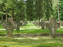
The village gained historical importance through the prisoner-of-war camp Stalag VIII B (344) Lamsdorf . From 1939 to 1945 it was one of the largest German prisoner-of-war camps. June 1945 to the autumn of 1946 it served as internment / labor camp in the expulsion of Germans from Silesia .
Attractions
- The Roman Catholic Church of St. Maria Magdalena (Polish Kościół św. Marii Magdaleny ) was built between 1873 and 1874 in the neo-Gothic style. A church was mentioned in the village as early as 1335. The timber structure was demolished in 1873.
- POW camp museum
- Entrance building of the Łambinowice train station
- Wayside chapel
- Stone wayside cross
societies
- Volunteer Fire Brigade OSP Łambinowice
- KS Metalowiec Łambinowice football club
Web links
Individual evidence
- ↑ a b c d Bielice - dates (Polish)
- ^ Johann Georg Knie : Alphabetical-statistical-topographical overview of the villages, spots, cities and other places of the royal family. Preuss. Province of Silesia. Breslau 1845, p. 345.
- ↑ a b Cf. Felix Triest: Topographisches Handbuch von Oberschlesien. Breslau 1865, p. 1154.
- ^ Meyer's Large Conversational Lexicon . 19th volume, Leipzig, Vienna 1908, p. 700.
- ↑ a b territorial office district Nüßdorf / Mauschwitz / Mauschdorf
- ↑ District of Falkenberg OS
- ↑ Michael Rademacher: German administrative history from the unification of the empire in 1871 to the reunification in 1990. City and district Falkenberg OS (Polish Niemodlin). (Online material for the dissertation, Osnabrück 2006).
- ^ CIS 2011: Ludność w miejscowościach statystycznych według ekonomicznych grup wieku ( XLSX file, Polish), March 31, 2011, accessed on June 10, 2019
- ↑ History of the Church in Łambinowice (Polish)


