Long soaps
|
Long soaps
City of Bad Schwalbach
|
|
|---|---|
| Coordinates: 50 ° 7 ′ 13 ″ N , 8 ° 0 ′ 34 ″ E | |
| Height : | 421 m above sea level NHN |
| Residents : | 500 (Oct 11, 2007) |
| Incorporation : | December 31, 1971 |
| Postal code : | 65307 |
| Area code : | 06124 |
|
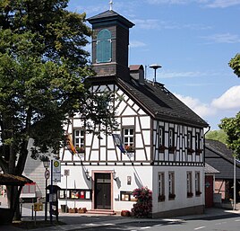
Town hall in the town center
|
|
Langenseifen is the westernmost district of the city of Bad Schwalbach in the Rheingau-Taunus district in southern Hesse .
geography
Langenseifen is located west of Bad Schwalbach on a ridge that belongs to the Western Aartaunus , but branches off far to the west and rises high above the valleys of the Dornbach in the north and the Fischbach in the south, which are already included in the Wispertaunus .
Langenseifen is surrounded by extensive agricultural areas, which are framed by partly steeply sloping wooded valley slopes.
history
Langenseifen was first mentioned in a document in 1270 as Langensiven . It was one of the 15 elevated villages that, according to a border description of the Rheingau Weistum from 1324, belonged to the Kurmainzian territory and lay outside the Rheingau Gebück . The center of the high villages was Bärstadt .
At the time of the Duchy of Nassau , Michelbach belonged to the Langen-Schwalbach office . After the annexation by Prussia, it was assigned to the Untertaunuskreis in the Wiesbaden administrative district in 1867 .
In the course of the regional reform in Hesse , the municipality of Langenseifen was incorporated into the city of Bad Schwalbach on December 31, 1971, together with five neighboring municipalities on a voluntary basis. As for every district outside the core city, the main statute established a local district for Langenseifen with a local advisory board and local councilor .
Culture and sights
Buildings
Townscape
The townscape is characterized by the following historical buildings: the school built in 1822 at the western end of the town (today a local museum), the fountain house from 1832 and the town hall built in 1839 in the center of the town.
chapel
The Evangelical Field Chapel has stood above the village since 2012 . The unique dome made of natural larch wood offers space for 60 visitors.
From 2005 ideas for the first church building in Langenseifen were developed. As a first step, an altar should be erected in the open field. The sculptor Holger Walter set up a 3.92 m high natural basalt lava column. In 2007 a group of visitors from Iceland made a special trip to Langenseifen to see the "Altar in the Field".
The architect Barbara Schmid then designed the chapel, which was built around the existing sculpture. The sculpture is now in the service room and can be used as an altar. The otherwise windowless room only receives natural light through a round glass window directly above the altar. It has a characteristic atmosphere and is used for various events.
societies
The club's life includes the Liederkranz men's choir in 1896, the volunteer fire brigade in 1934, the sports club in 1963, the home club “Bei uns deham” and a senior citizens' club.
Economy and Infrastructure
tourism
Langenseifen is ideal for nature lovers as a starting point for hikes through the hinterland forest in the Wispertaunus . The Wispertaunus is one of the most densely forested parts of the Taunus and has largely been designated as an FFH area. In addition, the entire region is part of the Rhein-Taunus Nature Park , which aims to enable people to relax in a natural environment.
traffic
Langenseifen is on the L 3374, which is the shortest connection from Bad Schwalbach to the Wispertal to Geroldstein and Lorch in an east-west direction . Three kilometers east of Langenseifen, the country road connects to the federal highway 260 , via which one can reach Wiesbaden and the Rhine-Main area to the south .
Web links
- Districts. In: Internet presence. City of Bad Schwalbach
- Langenseifen, Rheingau-Taunus-Kreis. Historical local dictionary for Hessen. In: Landesgeschichtliches Informationssystem Hessen (LAGIS).
- Literature on long soaps in the Hessian Bibliography
Individual evidence
- ↑ Westlicher Aartaunus, Zorner plateau, Katzenelnbogen plateau, Nastätter Mulde and Unterlahnhöhen
- ↑ a b Topographic map 1: 25,000
- ↑ cf. Hinterland forest
- ^ Federal Statistical Office (ed.): Historical municipality directory for the Federal Republic of Germany. Name, border and key number changes in municipalities, counties and administrative districts from May 27, 1970 to December 31, 1982 . W. Kohlhammer, Stuttgart / Mainz 1983, ISBN 3-17-003263-1 , p. 377 .
- ↑ main statute. (PDF; 85 kB) § 6. In: Website. City of Bad Schwalbach, accessed February 2019 .
- ↑ State Office for the Preservation of Monuments Hesse (ed.): Lorcher Strasse 34: Town Hall In: DenkXweb, online edition of cultural monuments in Hesse
- ^ Art Chapel Project
- ↑ Parish chapel
- ↑ Obo: At the beginning there is the altar stone. In: Frankfurter Allgemeine Zeitung, September 10, 2005, No. 211, p. 70.
- ↑ Thorsten Stötzer: Altar stone impresses Icelanders. In: Wiesbadener Tagblatt, November 21, 2007
- ↑ Like a little cathedral. In: FAZ of June 4, 2012, p. 37


