
Langlütjen
_2012-05-13-DSCF8515.jpg)
_2013-05-03-DSCF7456.jpg)

Langlütjen (formerly: Langlütjensand ) is the name of the two mudflat islands artificially created in the 19th century, Langlütjen I and Langlütjen II in the Weser estuary. Politically, the islands belong to the area of the Lower Saxon town of Nordenham on the Lower Weser . On them are the remains of first Prussian and later Imperial Navy - forts , the task of protecting the Ports of Bremen was. In 1933 Langlütjen II was a protective custody camp of the SA for some time .
Langlütjen is also the name of a beacon (upper and lower lights as beacons ) as a navigation mark in the Weser estuary.
location
The two islands with 16,000 and 17,000 m² are 2 km away from each other in the Langlütjensand mudflat area near the mouth of the Weser, which dries out at low tide . The Weser fairway runs about 1 km east of them . The islands can be reached on foot through the tidal flats at low tide and by boat at high tide. After Langlütjen I one leads from the mainland dam . The islands are opposite the city of Bremerhaven . You are at the level of the Nordenham district of Blexen in the Lower Saxony Wadden Sea National Park . Within the national park, Langlütjen I belongs to protection zone I (quiet zone), Langlütjen II to protection zone II.
Building development
The two island fortresses were built according to plans by the royal engineering committee in Berlin. The construction is based on Belgian fortifications and French island forts of the 17th century in the style of the military architect Vauban . The construction of the artificial islands caused considerable difficulties in the 19th century. The construction sites with their temporary location in the water were exposed to the forces of the sea. The structures had to be firmly established because they later carried heavy fortifications and guns. They should also withstand enemy artillery fire .
Former military significance
From the middle of the 19th century to the middle of the 20th century, the artificially raised islands served as coastal forts to protect against attacks from the sea. Together with the no longer existing Weser forts Brinkamahof I and II in front of Bremerhaven they formed a fortress square . The fact that coastal fortifications were necessary at that time became apparent during the German-Danish War of 1864, when the superior Danish fleet threatened the German North Sea coast and brought trade to a standstill.
Langlütjen I


On the former sand dune Langlütjensand , an artificial island was built in 1869/1870, which was turned into a fortified coastal fort with earth walls ( 53 ° 33 ′ N , 8 ° 31 ′ E, ). There are only records of the construction work for Langlütjen I , which should be equally valid for Langlütjen II . The costs for Langlütjen I were estimated at 300,000 thalers before construction began , the actual amount is not known.
Around 300 men worked on the plant at the same time. All building materials for the work that began in 1869 were brought by ship. From 1870, the dam, which still exists today, was used for this purpose, on which a narrow-gauge railway with a track width of 837 mm ran. During the low tide, the construction site was free of water for around five hours in calm weather, and only two hours in rough seas. The work could only be carried out from March to December. 112,000 oak stakes were driven into the ground. In the foundations are 300,000 bundles of bushes, 2,700 m³ of brick rubble and 1,900 m³ of sandstone blocks from quarries near Hameln and Springe . The island is connected to the mainland by a 1.6 km long causeway.
Upon completion, the fort received nine 21 cm guns in armored turrets and was used until the end of World War I , but was never involved in combat operations. After the end of the war, demilitarization took place and the armament was removed by the victorious powers.
Flak battery Langlütjen I
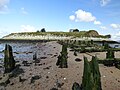
During the Second World War , the armament was switched to anti-aircraft positions with 10.5 cm guns in newly built, concreted gun positions. The facilities were blown up after the war. The debris was washed over with sand in the 1970s for reasons of coastal protection . However, debris still protrudes from the sand.
post war period
In addition to the dam leading to the mainland, a radar tower for Weser shipping was built near the island in 1983 . The 2006 All Saints flood hit the north shore of the island badly. The concrete bank was washed away and the panels pushed one on top of the other. Steep bank areas were created on the earthfill. Since around 1970 the condition of the stone bank reinforcements has deteriorated more than in the previous 100 years. Entering the island is prohibited.
vegetation
The vegetation of the island's interior is mainly made up of stinging nettle ( Urtica dioica ), field chervil ( Anthriscus sylvestris ), curly dock ( Rumex crispus ) and common ball grass ( Dactylis glomerata ). All species indicate high nutrient levels in the soil. Flat oat lawns form the vegetation of the dams in places and small areas. In the interior of the island, numerous elder bushes ( Sambucus nigra ) and several tall white willows ( Salix alba ) have grown up . The trees also give an indication of the nutrient-rich subsoil. The development of vegetation has been undisturbed since the end of the Second World War and points towards softwood floodplain forest as potential natural vegetation .
Salt plants typical of the mudflat are almost exclusively found on the dam below the beacon. These include chickweed ( Spergularia media ), beach aster ( Aster tripolium ), beach trident ( Triglochin maritimum ), milkweed ( Glaux maritima ) and English spoonweed ( Cochlearia anglica ).
An extensive Schilfried has developed in the brackish water swamp of the foothills of the island.
fauna
Diverse bird watching are possible from the island dam, for example shelduck , marsh harrier , whooper swan , oystercatcher and other limicoles , various terns and warbler . The Schilfried in the foothills of the island is an important breeding area.
Langlütjen II


Northwest of Langlütjen I , the island of Langlütjen II ( 53 ° 35 ′ N , 8 ° 30 ′ E ) was artificially piled up with sand in 1872–1876 . The island has no connection to the mainland and can only be reached by boat or on foot at low tide. It has an oval shape with a length of about 200 m and a height of 10 m above sea level. NN . A fort was built as a rectangular casemate structure made of brick masonry with rounded corners. The casemates have vaulted ceilings and are bulletproof. The fort is protected by an 8 m deep moat. It was put into operation in 1880 and was intended for a crew of 100 who could live here independently for up to four months. The armament in World War I consisted of five rotating armored turrets with 28 cm cannons and two separate 15 cm cannons. Although the enemy was expected, there was no fighting. After the First World War, the fort's military installations were dismantled by the victorious powers. During the Second World War, the fortification carried 2 cm anti-aircraft guns and searchlights.
"Protective custody camp" (provisional concentration camp)
From September 9, 1933 to January 25, 1934, there was a "protective custody camp" of the SA in the fortress of Langlütjen II . It was set up at the instigation of the Bremen Gestapo to take in political prisoners from the Bremen concentration camp Mißler . In addition to the SA guards, up to 100 prisoners are said to have been accommodated, for whom the deep moat served as a prison yard. The screams of tortured prisoners could be heard from miles away. When approaching the island, unannounced visitors were shot at without warning. The island was soon also called "Devil's Island" or "KZ under the sea" among the population. For cost reasons and because of the cumbersome supply, the prisoners' accommodation was discontinued after five months.
post war period
The island is in a poor structural condition. Since around 1970 the condition of the fortifications and the stone bank fortifications deteriorated considerably. Entering the island is prohibited. As part of city tours and mudflat hikes by the Nordenham Marketing and Tourism Association, Langlütjen II can be visited with a knowledgeable guide.
Importance as a monument
In 1996, the Lower Saxony State Office for the Preservation of Monuments assessed the architectural significance of the island of Langlütjen II as follows:
Because of the good state of preservation, the fort on Langlütjen II is an outstanding monument. The property is a unique military facility in Germany from the mid-19th century. It documents :
- National and regional history from the time the German Empire was founded in 1871
- political history from the beginning of the Nazi era
- Hydraulic engineering
- Defense technology of a sea fort
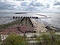
Langlütjen II from the pier

Ditch of the fortress, the patrol passage can be seen in the upper area.
Remnants of the island's pier

View of Bremerhaven


Island sale
The two islands have always belonged to the state, after the Second World War they belonged to the federal government . From around 2000 they were found to be dispensable and the Federal Agency for Real Estate Tasks offered them for sale as investor properties from August 2005 . The purchase price per island was given as at least 100,000 euros. Soft tourism was suggested as a type of use .
The islands were advertised with the text:
- Two unique islands are for sale, on which a piece of German history blends with the freshness of the North Sea air. Originally, these two artificially raised islands with their architecturally significant and globally unique fortress were used as an imperial naval fort for the military defense of the Weser estuary.
The sales intentions met with rejection in the population. On the other hand, it was proposed to set up a memorial on one of the two islands because of the earlier imprisonment of political prisoners in 1933/34. On November 5, 2005, a farmer from Spieka-Neufeld near Cuxhaven founded the "Inselfort Langlütjen II Association". The association wanted to collect money for the maintenance of the former fortress island and make it an attractive tourist destination .
After the Nordsee-Zeitung reported in December 2005 that both islands had been sold to a buyer from southern Germany, the Federal Agency for Real Estate Tasks (Oldenburg branch) announced on January 20, 2006 that the Wadden Islands were sold in 2006. The two buyers were advised that the islands are located in the middle of the Lower Saxony Wadden Sea National Park and are a listed building. The owners are therefore bound by the statutory nature and monument protection regulations.
Langlütjen I after the sale
The buyer is a businesswoman from Oldenburg. In 2015, the media reported that, according to the Lower Saxony Wadden Sea National Park Administration in Wilhelmshaven, larger groups of visitors were temporarily staying on the island with the permission of the owner, which disrupted the quiet zone of the national park. The owner thought of selling the island because of the disputes at the time, as she had a good offer.
Langlütjen II after the sale
The buyer is a Bremen businessman. In 2008, the Nordsee-Zeitung reported under the heading “Fortress Island Now Cultural Monument” that the Bremen buyer wants to “restore the island to its original state and make it usable for gentle tourism”.
In August 2008, a report by Bremer Kurier on Sunday said that the owner wanted to build a hotel on Langlütjen II. As early as 2005 it was said in case a hotel would be built on Langlütjen: “The postal address of the islands would then be: Wasserstr. 5298, Outer Weser. "
In 2010 there was an ideas competition among architecture students from the Technical University of Braunschweig to design a hotel on the island. Nine models were created in the process. In 2015, media reported that the owner was planning to build a hotel complex and condominiums for 10 million euros. At the time, he had invested around one million euros in securing work on the island and the renovation of the damaged bank revetment. The bank had been made stormproof. Backfilling with concrete turned out to be a mistake because "the pressure of the waves is no longer distributed". The casemates have now been tidied up and an island museum is planned there.
The project for tourist use has not made progress since then. In 2016, the Unterweser Regional Forum determined that there was a conflict between the construction plans and the interests of the Lower Saxony Wadden Sea National Park and its importance as a monument. In addition, the lack of renovation would jeopardize the preservation of the maritime structure.
reception
After extensive research, the director Jens-Erwin Siemssen from the theater group The Last Gem wrote a play that premiered on May 19, 2006 on the island under the title "Langlütjen II - Documentary Landscape Staging of an Island". The piece was sometimes performed at unusual times because the tide had to be taken into account when approaching the island . The visitors went on a circuit around the island and the history of the island was staged at various stations.
Others
- Right -wing extremist graffiti was left on various parts of the ruins of Langlütjen I and II .
See also
Myths and legends
- From the mold on Langlütjensand
literature
- Angelika Geiger, Walter Wulf: Langlütjen II - a former Weser fort is discovered as an architectural monument. In: Reports on the preservation of monuments in Lower Saxony , No. 1/96, p. 14 ff
- Investors wanted for concentration camp island. In: Waterkant magazine . 3/05, Aktionkonferenz Nordsee eV (Ed.), Bremen 2005.
- DAWA special volume 28: The Weserforts - Contributions to history. In the DAWA special volumes series . Werner Lacoste, ISBN 3-931032-90-6 .
- Peter Klan (Ed.): Langlütjen - two fortress islands in the Wadden Sea between Bremerhaven and Nordenham. History, architecture, nature, art, magical places. Kunstverein Nordenham eV, Nordenham 2011, ISBN 978-3-00-034150-2 .
- Julius Schreckenberg: fortress islands at the mouth of the Weser and Langlütjen II concentration camp. Ochtumsand. Brake 1993.
Web links
- Description of Langlütjen I and II with photos, also as a flak position 1941 ( Memento from October 16, 2010 in the Internet Archive )
- Data on the Langlütjen beacon
Individual evidence
- ↑ a b Jürgen Hinrichs: Ein Klecks vom Kaiser in: Kurier am Sonntag , Sunday edition of the Weser-Kurier from August 10, 2008, p. 35.
- ↑ Explanation of the goals of the Inselfort association .
- ↑ Nordsee-Zeitung, Bremerhaven, December 7, 2005
- ↑ Jonas Schönrock: Loud noises around the quiet zone in the mudflats in Nord West Zeitung from August 14, 2015
- ↑ Nordsee-Zeitung, Bremerhaven, June 14, 2008.
- ↑ The waterway 5298 is the Weser, see on the website of the Federal Waterways and Shipping Administration ( Memento of March 3, 2012 in the Internet Archive ) (PDF; 81 kB).
- ↑ Norbert Hartfil: Tailwind for Project Island Hotel in Nordwestzeitung from June 19, 2015
- ^ Preservation of the fortress island Langlütjen II in the Wadden Sea National Park as a monument of national importance , position paper for the Lower Weser Conference on January 19, 2016
- ↑ The sagas of the land of Wursten - Vom Schimmel auf Langlütjensand on YouTube , accessed on August 12, 2020.