
Ormont lingerie
| Ormont lingerie | |
|---|---|
.svg) |
|
| State : |
|
| Canton : |
|
| District : | Aigle |
| BFS no. : | 5410 |
| Postal code : | 1863 Le Sépey 1866 La Forclaz 1862 Les Mosses |
| UN / LOCODE : | CH SPY (Le Sépey) |
| Coordinates : | 570195 / 134550 |
| Height : | 974 m above sea level M. |
| Height range : | 701–2477 m above sea level M. |
| Area : | 64.11 km² |
| Residents: | 1120 (December 31, 2018) |
| Population density : | 17 inhabitants per km² |
| Website: | www.ormont-dessous.ch |
 Le Sepey |
|
| Location of the municipality | |
  |
|
Ormont-Dessous is a municipality in the district of Aigle in the canton of Vaud in Switzerland . The former German names Ormund and Ulmenthal are no longer used today.
geography
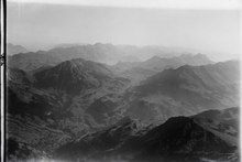
Ormont-Dessous is located around 9 km east-northeast of the district capital Aigle (as the crow flies). The community, which consists of several districts, is located in the central part of the Grande Eau valley , in the Les Ormonts valley in the Vaudois Alps.
The area of the 64.1 km² municipal area covers a section of the Vaudois Alps. The southern part of the municipality is occupied by the Alpine valley, which the Grande Eau flows through from east to west (to the Rhone ). South of the river, the area extends up the slope to the heights of Chamossaire (up to 1960 m above sea level ), Chaux Ronde (up to 2000 m above sea level ) and Tête de Meilleret ( 1939 m above sea level ). The lake Lac des Chavonnes is located in a depression on the northern slope of this mountain range .
The northern side of the valley of the Grande Eau is divided in the Ormont-Dessous area by the two short side valleys of Ruisseau du Sépey and La Raverette and the intervening ledge of Les Champs . The Raverette has its source near the Col des Mosses pass . The northern end of the valley is formed by the mountains Tour de Famelon (up to 2082 m above sea level ), Mont d'Or ( 2175 m above sea level ), Pic Chaussy ( 2351 m above sea level ) and Châtillon (at 2478 m above sea level ) above sea level the highest point of Ormont-Dessous). The main European watershed between the Rhone and the Rhine runs over this mountain range and the wide valley of the Col des Mosses between Mont d'Or and Pic Chaussy . The parts of the community on the other side of the Col des Mosses are drained by the Hongrin to the Saane and thus to the Rhine. In the far north, the municipality extends into the valley of the Petit Hongrin and also includes most of the Lac de l'Hongrin reservoir and its dam. In 1997, 4% of the municipal area was in settlements, 43% in forests and woodlands, 40% in agriculture and around 13% was unproductive land.
In the municipality there is the La Frasse slide , which threatens the main road 11 between Les Sépey and Aigle. The landslide has been active for around 12,000 years but was only discovered in the 19th century and documented in 1863. A drainage gallery was built between 2007 and 2009, which meant that the landslide could be reduced from 60 cm / year to 2.4 cm / year.
The municipality of Ormont-Dessous consists of the following villages and hamlets (there is no place with the same name as the municipality):
- Le Sépey, 974 m above sea level M. , administrative center of Ormont-Dessous, in a hollow of the Ruisseau du Sépey on the right slope of the Grande Eau
- La Forclaz, 1261 m above sea level M. , mountain farming village on a terrace on the left slope of the Grande Eau, on the northern slope of Chamossaire
- Cergnat, 1051 m above sea level M. , on the right valley slope of the Grande Eau, near Le Sépey
- Les Voëttes, 1274 m above sea level M. , scattered settlement on the right slope of the Grande Eau valley
- La Comballaz, 1344 m above sea level M. , at the entrance to the Col des Mosses, at the foot of the Mont d'Or
- Les Mosses, 1436 m above sea level M. , mainly a hotel and holiday home area on the Col des Mosses pass crossing
Neighboring municipalities of Ormont-Dessous are Villeneuve , Corbeyrier , Leysin , Aigle , Ollon , Ormont-Dessus and Château-d'Oex .
population


With 1120 inhabitants (as of December 31, 2018), Ormont-Dessous is one of the medium-sized communities in the canton of Vaud. 93.0% of the residents are French-speaking, 3.1% German-speaking and 1.5% Portuguese-speaking (as of 2000). The population of Ormont-Dessous was 1719 in 1870 and 1746 in 1900. In the course of the 20th century, the population decreased by around 50% to 884 inhabitants due to strong emigration until 1970. Only since the 1990s has the population increased again.
economy
Ormont-Dessous was a predominantly agricultural village until the end of the 19th century. With the improved transport connections since around 1870, the community gradually developed into a holiday resort.
Even today, dairy farming and animal husbandry have an important place in the income structure of the population. In the pre-alpine areas there are extensive alpine pastures for the summer grazing of the livestock. Further jobs are available in local small businesses (especially bricklayers 'and carpenters' workshops) and in the service sector. In the last few decades the village has also developed into a residential community. Many workers are commuters who work mainly in the larger towns of the Rhône Valley and in the Vevey-Montreux region.
tourism
The whole Ormont-Dessous area is geared towards both summer and winter tourism. The alpine meadows and mountains on both sides of the Les Ormonts valley are ideal for long walks and mountain hikes. The center of winter tourism is the Col de Mosses with numerous ski slopes, ski lifts and cross-country trails. There are also various hotels as well as many holiday and weekend homes.
traffic
The community is very well developed in terms of traffic. Le Sépey is on the main road that leads from Aigle over the Col des Mosses to Château d 'Œx. The road to Les Diablerets and the Col du Pillon branches off from this road east of the village.
Since December 22, 1913, Le Sépey has been connected to the Aigle-Sépey-Diablerets (ASD) narrow-gauge railway operated by the Transports Publics du Chablais (TPC) . The bus routes from Le Sépey to the Col des Mosses, to Leysin and to La Forclaz provide for the fine distribution of public transport.
history
The valley of Les Ormonts was probably reclaimed between the 7th and 9th centuries and settled by residents from the Rhône valley. The area belonged to the Abbey of Saint-Maurice , which came under the sovereignty of the Counts of Savoy in the 13th century. Aigremont castle was built around the middle of the 14th century under Aymon de Pontverre, which from then on held jurisdiction in the valley and was destroyed in the 15th century.
With the conquest of Aigle by Bern in 1476, Ormont-Dessous came under the administration of the Aigle governorate . Against the tough resistance of the valley population, the Reformation was introduced in 1529 . When the Ancien Régime collapsed in 1798, the population resisted taking possession by the French and Vaudois troops. In the mountain area of Ormont-Dessous, at the Col de la Croix and at La Forclaz, there were armed conflicts before the valley finally capitulated. As a result, Ormont-Dessous belonged to the canton of Léman from 1798 to 1803 during the Helvetic Republic , which then went into effect when the mediation constitution came into force in the canton of Vaud. In 1798 it was assigned to the Aigle district.
Since 2012, the community has been part of the Parc naturel régional Gruyère Pays-d'Enhaut .
Attractions
The reformed parish church is a little off the administrative center of Le Sépey on a small hill near Cergnat. It dates from the Middle Ages, the oldest part is the choir, the front tower with the pointed arch portal is in the late Gothic style. In Le Sépey and La Forclaz, wooden houses with masonry substructures and richly carved, partly painted facades from the 17th and 18th centuries have been preserved. The wooden granaries characteristic of the area date from the same period. On the hill near Les Voëttes above the valley of the Grande Eau, ruins of the former castle of Aigremont have been preserved.
Web links
- Official website of the municipality of Ormont-Dessous (French)
- La Forclaz website (French)
- Mary-Claude Busset-Henchoz: Le Sépey. In: Historical Lexicon of Switzerland .
- Mary-Claude Busset-Henchoz: Ormont lingerie. In: Historical Lexicon of Switzerland .
- Castle world: Château d'Aigremont
- Aerial view of Le Sépey
- Aerial views of La Forclaz
Individual evidence
- ↑ Permanent and non-permanent resident population by year, canton, district, municipality, population type and gender (permanent resident population). In: bfs. admin.ch . Federal Statistical Office (FSO), August 31, 2019, accessed on December 22, 2019 .
- ↑ Ch. Bonnard, L. Laloui, L. Tacher, E. Prina Howald, G. Steinmann, G. Schaeren, Ch. Heubi, F. Geiser and C. Taruffi: Long-term control of La Frasse Landslide: From theory to practice . In: Landslides and Engineered Slopes. Experience, Theory and Practice - Proceedings of the 12th International Symposium on Landslides (Napoli, Italy, 12-19 June 2016) . CRC Press, 2016, ISBN 978-1-138-02988-0 , pp. 461-466 , doi : 10.1201 / b21520-47 .
Aigle | Bex | Chessel | Corbeyrier | Gryon | Lavey-Morcles | Leysin | Noville | Ollon | Ormont lingerie | Ormont-Dessus | Rennaz | Roche (VD) | Villeneuve (VD) | Yvorne
Former parishes: Lavey | Morcles
Canton of Vaud | Districts of the canton of Vaud | Municipalities of the canton of Vaud