Lichta
|
Lichta
City of Koenigsee
Coordinates: 50 ° 39 ′ 19 ″ N , 11 ° 7 ′ 13 ″ E
|
|
|---|---|
| Height : | 356 (351-404) m |
| Area : | 1.85 km² |
| Residents : | 143 |
| Population density : | 77 inhabitants / km² |
| Incorporation : | 1st January 1974 |
| Incorporated into: | Koenigsee |
| Postal code : | 07426 |
| Area code : | 036738 |
|
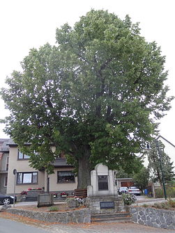
Central village square of Lichta, Thuringia with a war memorial
|
|
Lichta is a district of Königsee in the Saalfeld-Rudolstadt district in Thuringia .
location
The place is located in the Thuringian Forest Nature Park, southeast of the main town of Königsee. Lichta's highest mountain is called Milchberg.
history
The village was first mentioned in 1342 under the name Lychta . Until 1918 the place belonged to the sovereignty of the Principality of Schwarzburg-Rudolstadt .
Others
- Lines 31 and 33 of Omnibusverkehr Saale-Orla Rudolstadt GmbH ensure the connection to the surrounding towns.
Web links
Commons : Lichta - collection of images, videos and audio files

