
Würzberg Castle
| Würzberg Fort (Hainhäusel Fort / Hainhaus Fort) |
|
|---|---|
| limes | ORL 49 ( RLK ) |
| Route (RLK) | ORL route 10 Neckar-Odenwald-Limes Odenwald line |
| Dating (occupancy) |
trajanic up to max. 159 ad |
| Type | Numerus fort |
| unit | unknown number |
| size | 74 × 81 m = 0.6 ha |
| Construction | a) Wood and earth fort b) Dry stone wall c) Mortar wall |
| State of preservation | Partial preservation |
| place | Michelstadt - Würzberg |
| Geographical location | 49 ° 38 ′ 3 ″ N , 9 ° 4 ′ 31 ″ E |
| height | 525 m above sea level NHN |
| Previous | ORL 48 Fort Eulbach (north) |
| Subsequently | ORL 50 Fort Hesselbach (south) |
The Würzberg Fort (in older literature also Fort Hainhäusel or Fort Hainhaus ) was a Roman numerus fort on the older Odenwald line of the Neckar-Odenwald-Limes . Today's ground monument is located south of Würzberg , a somewhat remote, smaller district of Michelstadt in the Hessian Odenwald district .
location

The ground monument Kastell Würzberg is located about two and a half kilometers south of the village of the same name, in a clearing on the northern edge of the forest, which extends between Würzberg and Bullau , the closest village to the south. Topographically, it is located at around 525 meters above sea level on a mountain ridge that runs through the Odenwald from north to south.
The area on which the ground monument is located is slightly inclined in two directions. It drops from the former west to the east side of the fort as well as from its north to south side by about one meter each.
Research history
Possibly the fort area is identical to the Wllineburch mentioned in a description of the Mark Michelstadt from 819 or the destructa Vullonoburg in a document about the Lorsch Wildbann in 1012 . The first reliable description dates from 1736.
At the beginning of the 19th century, the fort was examined by Johann Friedrich Knapp on behalf of Count Franz I zu Erbach-Erbach (1754–1823) using the methods of the time. The first scientific excavations were carried out in 1895 by the Reich Limes Commission under the local excavation management of Friedrich Kofler . Another archaeological investigation followed in 1963 by the Saalburg Museum under the direction of Dietwulf Baatz . These excavations and the resulting publication, together with the excavations in the neighboring fort Hesselbach, paved the way and enabled analogue reconstructions of other numerus forts of the Odenwald Limes.

The Würzberg fort is considered to be one of the best preserved numerus forts in the Odenwald Limes. The contours of the fort's fortifications can still be seen today in the non-built-up area. The foundations of the fort bath and parts of the rising masonry have been preserved and thus give a comprehensive impression of the structure of such a building.
- Exposure of the fort thermal baths by the Reich Limes Commission (1895)

View from the northeast of rooms A, B, C, C 1 and D
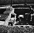
View from the northwest to rooms B and B 1

View from the south of rooms B, A and A 2

View from the southwest of rooms C 1 , C, B, A and A 2


Findings
Fort
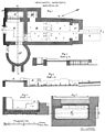
The fort area extends over an area of around 6,000 square meters and thus corresponds to the typical size of a numerus fort in the Odenwald. The walling was made in the form of an uneven square. The pretorial front (front) measured 72.03 m, the length of the rear front was 74.10 m. The wall on the left, northern side was 81.03 m long, the one on the right, southern side was 80.63 m long. The thickness of the foundation was 1.25 m, that of the rising masonry 90 cm to 95 cm. The fence was equipped with a total of four entrances. The main gate (Porta praetoria) faced the Limes. The rear camp gate (Porta decumana) only existed in the form of a small hatch , which was probably only used in the first construction phase and later bricked up. The rounded corners of the wall were not provided with defense towers. While Kofler had assumed that the gates had no defensive towers either, Baatz came to the conclusion that both the Porta praetoria and the Porta principalis sinistra (left side gate) and the Porta principalis dextra (right side gate) presumably had gate towers analogous to this Hesselbacher Fort, but required further excavations for final clarification. In front of the fence, following a 50 to 80 cm wide berm , there was a six meter wide trench (fossa) , the depth of which was only one meter below the level of the berm. It was designed in the form of a so-called Fossa punica , that is: the trench wall facing the enemy was deepened significantly more steeply than the one facing the camp. In the areas immediately in front of the gates, the ditch was interrupted by earth dams.
In the interior of the fort, the via sagularis (Wallstrasse) , which had been graveled since the second construction phase, was found in connection with the wall that supported the battlement . The location of the Via principalis (main warehouse street connecting the side gates) and Via praetoria (arterial road) are also secured. Traces of interior structures could not be found at all (Knapp) or only rudimentary (Kofler and Baatz) during all three excavation campaigns. In all construction phases, they were likely to have consisted of half-timbered buildings with possibly clad floors.
The investigations of 1963 finally revealed the following construction phases:
- In Trajan times the camp was built with a wood-earth wall.
- In Hadrianic times , i.e. between 117 and 138 AD, the wooden fence was replaced by a double dry stone wall filled with earth in the space .
- Between 140 and 150 AD, the dry masonry was replaced by a mortar stone wall.
- With the advancement of the Limes , the fort (like the entire Odenwald Limes ) was given up no later than 159 AD.
This results in the same sequence as has been proven for the Hesselbach fort and as it is typical for all forts in the Odenwald Limes. Nothing is known about the number stationed here , an auxiliary troop unit of around 160 men .

Fort floor plan
Findings from the excavations of 1895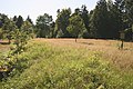
In the terrain visible contour of the former fence

In the area visible contour of the former fence with information boards


Vicus and thermal baths
A fort vicus was detected in follow-up examinations in the 1930s, but not published.
About 60 meters south of the Porta principalis dextra (right camp gate) was the fort bath, which had all the functions of the typical Roman thermal baths on a small scale and was examined and preserved by the Hessian State Monuments Office in 1980. From north to south, a wooden apodyterium (changing room) in a stone building was followed by a frigidarium (cold bath, room A) with piscina (cold water bath, A 1 ), a tepidarium (leaf bath, B) with a corresponding bath (B 1 ) and a caldarium ( Warm bath, C) with warm water tub (C 1 ). To the west of the frigidarium was a circular sudatorium (dry sweat bath, A 2 ). A total of two prefurnia (boiler rooms), west of the sudatorium and south of the caldarium (D), provided the necessary water and room temperatures. The bathroom was plastered and painted and had taps with running cold and warm water and glass windows. The building material also included bricks from the cohors XXIIII voluntariorum civium Romanorum ("24th cohort of voluntary Roman civil rights") stationed in Heidelberg-Neuenheim

Fort bath, view from SSW with the Praefurnium in the foreground, the sudatorium bulging to the left

Fort bath, view of the entire complex with the sudatorium in the foreground
Fort bath at the time of the excavations in 1895

Drawing reconstruction of the thermal baths

Aerial view


Limes course between the forts of Würzberg and Hesselbach
From the Würzberg fort, the Limes continues over a wooded ridge of the Odenwald that runs from north to south. It gradually drops from 525 to 489 meters in altitude. Up to the towers in the northern edge of Hesselbach, all Limes structures are more or less clearly visible. The moats with a wall-like elevation that can occasionally be seen between the forts in the immediate vicinity of the watchtowers, like the Limes, are not related to the Limes, but belong to a medieval Landwehr .
| ORL | Name / place | Description / condition |
|---|---|---|
| ORL 49 | Würzberg Castle | see above |
| Wp 10/26 | "In the bag" |
Visible tower site with a stone and a wooden tower hill, which was examined by Eduard Anthes in 1895 .
The stone tower had a square floor plan with sides of 5.40 m, its wall thickness was 95 cm. The wooden tower was around 25 m away. The foundation of the wooden tower consisted of square dry stone masonry with a side length of 5.20 m, three beam slots on each side and notches for postings at each corner. It was surrounded by a ring trench with a diameter of 17 m to 18 m, the slope of which was made steeper on the outside than on the inside. 28.40 m east of the wooden tower, the tower was passed by the Limes palisade. |
| Wp 10/27 | "In the history" |
Still visible tower point made of a stone and a wooden tower hill, which was examined by Anthes and Wilhelm Soldan in 1895 and which is very similar to the tower point Wp 10/26.
The stone tower had a square floor plan with a side length of 5.20 m and was already badly damaged at the time of the excavation. The wooden tower was located about 24 m north of the stone tower. The wooden tower had the best-preserved dry stone masonry in the entire Limes section, which was still up to a meter high when it was excavated. It had a square floor plan with a side length of 5.20 m, had three beam slots on each side and 60 cm by 60 cm rebates to accommodate the corner posts. The tower was surrounded by a ring moat 17.50 m in diameter and 1.40 m deep. The distance of the Limes palisade was measured at 33.5 m, but the value, which deviates significantly from the average distances for no apparent reason, does not appear to be entirely certain |
| Wp 10/28 | "In the upper lake" |
Visible tower site of a wooden and a stone tower, which was examined by Eduard Anthes in 1895. At the time of the investigation, the stone tower had already been largely destroyed, presumably by modern road construction work. A singularity on this Limes stretch was the screed layer found inside the tower, interspersed with bricks. Outside the tower was provided with an extraordinarily ornamented cornice. The wooden tower located 23 m south of the stone tower had also suffered some damage from recent construction work. The southeastern part of the tower was already completely destroyed by the construction of a drainage ditch. The drywall foundation of the wooden tower had a square floor plan with a side length of 5.10 m. The wall thickness was 1.00 m and probably only had two beam slots on each side. The tower was surrounded by a ditch around 14 m in diameter and 1.75 m deep. The Limes palisade ran at a distance of around 30 m east of the two towers.
|
| Wp 10/29 | "In the lower lake" |
Recognizable tower, which was first examined in 1880 by Gustav Dieffenbach and Robert Schäfer on behalf of the General Association of German History and Antiquity Associations and, more precisely, in 1895 and 1896 by Anthes and Soldan for the Imperial Limes Commission. The tower site consists of a wooden and a stone tower. The stone tower had a square floor plan with a side length of 5.85 m. At the time of the investigations, the rising masonry was still preserved up to a height of ten stone layers, the wall thickness was 98 cm in the plinth and foundation area and 90 cm in the rising. Two building inscriptions attest to the construction of the stone tower in 145 by a department of the Brittones Triputienses . The drywall foundations of the wooden tower were carried out more carefully compared to other towers on this Limes stretch. The wall thickness was around one meter on three sides, but 1.50 m on the west side. The usual three beam slots could not be found on the west side. This and the unusual thickness of the wall indicate that this side will be strengthened at a later stage of construction (possibly in connection with repair work). The tower, which was originally roughly square, was given a rectangular shape with sides 5.10 m by 5.40 m. During a follow-up examination in 1896, some findings suggested that the entire complex could be fenced off with a palisade. However, since these findings have not been adequately documented, their interpretation cannot be regarded as completely secure. The Limes palisade with the Limes accompanying path at this point about 4.50 m wide passed the tower site about 32 m east of the wooden tower and 28 m east of the stone tower.
|
| Wp 10/30 | "In the bird tree hedges" |
Preserved and reconstructed tower part of a stone and a wooden tower together with a reconstructed Limes palisade. The stone tower was examined by Friedrich Kofler during the excavations of the Hesselbach fort, the wooden tower by Anthes in 1895. The stone tower had a square floor plan with a side length of 4.80 m. The wooden tower hill, clearly visible in the area, carried a drywall foundation with a square floor plan, the side length of which was 5.25 m and the wall thickness was 65 cm. Inside, the tower foundation was divided into two unequal sized rooms by another 90 cm thick dry stone wall. In addition, the western wall in the larger, southern area was reinforced to a width of 1.20 m. The tower was surrounded by a ring moat with a diameter of 20 m. The Limes palisade passed the wooden tower 30 m to the east. At a distance of 8 m to 10 m the Limes accompanying path was in front of it, the width of which was determined at this point with the unusual dimensions of 7.50 m and 9.00 m. The palisade itself, the traces of which have been observed for the first time at this point across the entire Odenwald Limes, has been examined particularly carefully in the area of Wp 10/30. It consisted of 25 cm to 30 cm thick trunks, which were fixed in a 1.40 m deep trench by means of moist, tamped earth with the help of wedge stones. The tower was exposed and cleaned again in 1979 by the Rotary Club Erbach-Michelstadt . Afterwards, in consultation with the State Office for the Preservation of Monuments of Hesse, the rising masonry of the stone tower and the foundation wall of the wooden tower were preserved and partially rebuilt. Furthermore, a piece of the Limes palisade was reconstructed. The completeness of the ensemble brought to bear in this way makes it one of the best preserved of the Odenwald Limes.
|
| Wp 10/31 | "In the Saufeld" | Due to the average distance between the Limes watchtowers and the topographical conditions, the suspected tower location, which, however, could not be archaeologically proven. In 1966 Dietwulf Baatz found worked sandstone fragments in this corridor, which lay in piles of stone along a corridor boundary. This area was around 100 m south of the location assumed by the RLK. |
| ORL 50 | Fort Hesselbach |


Monument protection
The Würzberg fort and the adjacent Limes structures are ground monuments according to the Hessian Monument Protection Act . Investigations and targeted collection of finds are subject to approval, and accidental finds are reported to the monument authorities.
See also
literature
- Dietwulf Baatz : Würzberg fort, excavation 1963 . In der .: Fort Hesselbach and other research on the Odenwald Limes. Gebr. Mann, Berlin 1973, ISBN 3-7861-1059-X , (Limes Research Volume 12), p. 115ff.
- Dietwulf Baatz: Würzberg. In: The Romans in Hesse. Nikol, Hamburg 2002, ISBN 3-933203-58-9 , p. 498ff.
- Dietwulf Baatz: The Roman Limes. Archaeological excursions between the Rhine and the Danube. Gebr. Mann, Berlin 2000, ISBN 3-7861-2347-0 , pp. 188f.
- Ernst Fabricius , Felix Hettner , Oscar von Sarwey (eds.): The Upper Germanic-Raetian Limes of the Roemerreiches , Department A, Volume 5: Route 10 (The Odenwald Limes from Wörth am Main to Wimpfen am Neckar), 1926, 1935.
- Holger Göldner, Fritz-Rudolf Herrmann : Würzberg fort on the Odenwald Limes . State Office for Monument Preservation Hesse, Wiesbaden 2001. ISBN 3-8982-2153-9 , (Archaeological Monuments in Hesse, 153)
- Friedrich Kofler in: The Upper Germanic-Raetian Limes of the Roemerreiches (Eds. Ernst Fabricius, Felix Hettner, Oscar von Sarwey): Department B, Volume 5, Fort No. 49 (1896)
- Margot Klee: The Roman Limes in Hessen. History and sites of the UNESCO World Heritage. Pustet, Regensburg 2009, ISBN 978-3-7917-2232-0 , pp. 192-196
- Egon Schallmayer : The Odenwald Limes. Along the Roman border between the Main and Neckar. Theiss, Stuttgart 2010, ISBN 978-3-8062-2309-5 , pp. 97-104.
- Egon Schallmayer: The Odenwald Limes. Latest research results. Contributions to the scientific colloquium on March 19, 2010 in Michelstadt . Saalburgmuseum, Bad Homburg 2012, ISBN 978-3-931267-07-0 (= Saalburg-Schriften , 8)
Web links
- Numerus fort Würzberg on the private Limes project page of Claus te Vehne
Remarks
- ↑ a b The conventional starting date of the year 100 (± 5) is based on the results of the excavations that Dietwulf Baatz carried out in the Hesselbach fort between 1964 and 1966 . It is essentially based on the evaluation of the sigillates found (cf. the corresponding section in the Hesselbach article and Dietwulf Baatz: Fort Hesselbach and other research on the Odenwald Limes. Gebr. Mann, Berlin 1973, ISBN 3-7861-1059-X , ( Limesforschungen, Volume 12), pp. 85-96). In more recent literature, an initial dating of the Hesselbach fort and the entire Odenwald Limes to the period 107/110 is given preference. This dating approach is not based on new excavation findings, but on a statistical reassessment of the coin finds from all forts of the Upper Germanic-Raetian Limes, which the archaeologist Klaus Kortüm presented for the first time in 1998 and on which some authors of the more recent literature now rely. (cf. Klaus Kortüm: On the dating of the Roman military installations in the Upper German-Raetian Limes area . In: Saalburg-Jahrbuch 49, 1998. Zabern, Mainz 1998, pp. 5–65 and Egon Schallmayer : Der Limes. History of a border . Beck, Munich 2006, ISBN 3-406-48018-7 , pp. 49–52 and pp. 54f.)
- ↑ Not to be confused with the Hainhaus fort of the same name , ORL 47, near Michelstadt - Vielbrunn .
- ↑ Inde ad Wllineburch, per unam portam intro, by alteram foras . See Thomas Ludwig: The borders of the Mark Michelstadt in the year 819. In: Thomas Ludwig, Otto Müller and Irmgard Widdra-Spiess: The Einhards basilica in Steinbach near Michelstadt in the Odenwald . Edited by the State Office for Monument Preservation Hessen. Zabern, Mainz 1996, ISBN 3-8053-1322-5 , pp. 8–11, here p. 9, with further sources.
- ↑ According to ORL B 5, Fort 49, p. 1, note 1.
- ↑ Daniel Schreiber: History and family table of the Hoch-Graflichen Haus Erbach . Frankfurt 1736, pp. 258f.
- ^ Johann Friedrich Knapp: Roman monuments of the Odenwald, in particular of the county of Erbach and the rule of Breuberg . Engelmann, Heidelberg 1813; 2nd edition Meder, Heidelberg 1814; 3rd edition Jonghaus, Darmstadt 1854 and Erbacher catalogs .
- ↑ Dietwulf Baatz: Fort Würzberg, excavation 1963 . In der .: Fort Hesselbach and other research on the Odenwald Limes. Gebr. Mann, Berlin 1973, ISBN 3-7861-1059-X , (Limes Research Volume 12), p. 115ff.
- ↑ ORL B 5, 49, p. 3.
- ↑ Dietwulf Baatz: Fort Würzberg, excavation 1963 . In der .: Fort Hesselbach and other research on the Odenwald Limes. Gebr. Mann, Berlin 1973, ISBN 3-7861-1059-X , (Limes Research Volume 12), p. 116.
- ↑ Egon Schallmayer: The Odenwald Limes. Along the Roman border between the Main and Neckar. Theiss, Stuttgart 2010, ISBN 978-3-8062-2309-5 , pp. 97f.
- ↑ AE 1896, 00127
- ↑ Egon Schallmayer: The Odenwald Limes. Along the Roman border between the Main and Neckar . Theiss, Stuttgart 2010, ISBN 978-3-8062-2309-5 , p. 98.
- ^ Margot Klee: The Roman Limes in Hesse. History and sites of the UNESCO World Heritage. Pustet, Regensburg 2009, ISBN 978-3-7917-2232-0 , pp. 192f.
- ↑ ORL = numbering of the Limes structures according to the publication of the Reich Limes Commission on the O bergermanisch- R ätischen- L imes
- ↑ ORL XY = consecutive numbering of the forts of the ORL.
- ↑ Wp = W oh p east, watch tower. The number before the slash denotes the Limes section, the number after the slash denotes the respective watchtower.
- ↑ Wp 10/26 at about 49 ° 37 '41 " N , 9 ° 4' 52" O .
- ↑ Egon Schallmayer: The Odenwald Limes. Along the Roman border between the Main and Neckar. Theiss, Stuttgart 2010, ISBN 978-3-8062-2309-5 , pp. 99f. and Fig. p. 101.
- ↑ Wp 10/27 at about 49 ° 37 '9 " N , 9 ° 4' 47" O .
- ↑ According to ORL A 5.1, p. 58, it may be a measurement or documentation error.
- ↑ Egon Schallmayer: The Odenwald Limes. Along the Roman border between the Main and Neckar. Theiss, Stuttgart 2010, ISBN 978-3-8062-2309-5 , p. 100.
- ↑ Wp 10/28 at about 49 ° 36 '42 " N , 9 ° 4' 48" O .
- ^ Wp 10/28 on the private Limes project page by Claus te Vehne.
- ↑ Egon Schallmayer: The Odenwald Limes. Along the Roman border between the Main and Neckar. Theiss, Stuttgart 2010, ISBN 978-3-8062-2309-5 , pp. 100f.
- ↑ Wp 10/29 at about 49 ° 36 '6 " N , 9 ° 4' 57" O .
- ↑ IM (peratori) CAE (sari) ANT (onini) AVG (usto) / BR (i) TT / (ones) TR (i) PVTIENSES (Schillinger 00052 = RSO 00247 = CSIR-D-02-13, 00243; translated : "To the Imperator Caesar Antoninus Augustus the Brittones Triputienses") and (Imperatore A) N / (toni) NO / (IIII C) O (n) S (ule) (CSIR-D-02-13, 00242; translated: " The year in which Emperor Antoninus was consul for the fourth time ”).
- ↑ Egon Schallmayer: The Odenwald Limes. Along the Roman border between the Main and Neckar. Theiss, Stuttgart 2010, ISBN 978-3-8062-2309-5 , pp. 101f.
- ↑ Wp 10/30 at 49 ° 35 '40.3 " N , 9 ° 5' 3.55" O
- ↑ Holger Göldner and Fritz-Rudolf Herrmann: Wachtposten 10/30 “In den Vogelbaumhecken” and Hesselbach Fort on the Odenwald Limes . Office for Monument Preservation Hessen, Wiesbaden 2001, ISBN 3-89822-154-7 (Archaeological Monuments in Hessen, 154).
- ↑ Egon Schallmayer: The Odenwald Limes. Along the Roman border between the Main and Neckar. Theiss, Stuttgart 2010, ISBN 978-3-8062-2309-5 , p. 102f.
- ↑ Wp 10/30 on the private Limes project page by Claus te Vehne.
- ↑ Wp 10/31 at about 49 ° 35 '8 " N , 9 ° 4' 56" O .
- ↑ It is possible that there were two watchtowers between Wp 10/30 and the Hesselbach numerus fort.
- ↑ Egon Schallmayer: The Odenwald Limes. Along the Roman border between the Main and Neckar. Theiss, Stuttgart 2010, ISBN 978-3-8062-2309-5 , pp. 103f.
- ↑ Fort Hesselbach at 49 ° 34 ′ 34.5 ″ N , 9 ° 5 ′ 26 ″ E