
List of architectural monuments in Beilngries
The monuments of the Upper Bavarian town of Beilngries are compiled on this page . This table is a partial list of the list of architectural monuments in Bavaria . The basis is the Bavarian Monument List , which was first drawn up on the basis of the Bavarian Monument Protection Act of October 1, 1973 and has since been managed by the Bavarian State Office for Monument Preservation . The following information does not replace the legally binding information from the monument protection authority.


Ensembles
.jpg)
The ensemble includes the town of Beilngries within the boundaries of its historical fortifications, which have largely been preserved. The impressively preserved image of the small town comes mainly from the 16th to 18th centuries on the basis of medieval floor plans, enhanced by the new baroque construction of the parish church from 1913.
The place Beilngries, located on the old Carolingian Nordgau in a valley widening at the influence of the Sulz in the Altmühl, was first mentioned in 1007 in connection with the goods equipment of the new diocese of Bamberg. Through an exchange, the place came to the bishops of Eichstätt in 1016; this could already in 1053 from Emperor Heinrich III. obtain the market and customs rights. The market town developed on the right bank of the Sulz, at a noble ministerial seat on the place of the later church, to which three Meierhöfe were assigned. In addition, until the 19th century, the place was at the intersection of important north-south and east-west long-distance connections. The old roads led from Ingolstadt to the Upper Palatinate and from Eichstätt to the Regensburg Danube Valley, always via Beilngries.
The dominant element in the roughly pentagonal city plan is the main street, in whose arched route, offset at Schrannenplatz, the train of that old south-north thoroughfare is still recognizable. The first church built in the market town in the 12th century and all the more important buildings were assigned to this axis. The narrow eastern half of the city shows older, irregular ground plan structures, while the larger western half, which tends towards a rectangle, with its structure opened up by straight alleys, illustrates a later, high medieval city expansion. Beilngries has been fortified since the early 15th century. The large number of stately defense towers, nine of which have been preserved, indicated the secured market place, which had called itself a city since 1443. The prince-bishop provincial and town lords set up Beilngries as the center of a nursing office (Oberamt). Until 1740, the keeper's seat was Hirschberg Castle, located northwest above the town and dominating the valley. But the main official buildings were built in the city regardless. The most important of these buildings is the box house from the 16th or 17th century, a large, massive granary in the center of the city, indented into the main street. The street is divided there into the upper and lower market and is accompanied to the east by the small Schrannenplatz.
The image of the main street is also determined by mostly stately, partly staggered, middle-class gabled houses from the 16th to 18th centuries with stepped gables, blind arcades or protruding half-timbered storeys, some with bay windows. In addition, some buildings have the gently sloping gables of the Altmühljura houses. Between these historical buildings of the traders, innkeepers and craftsmen, the other prince-bishop's office buildings built in the 18th century - the former rent office, the former upper office, and the former forest office - convey their own emphatically baroque accents, which refer to the prince-bishop's rule that ended in 1802 refer. The parish church of St. Walburga, to which the parish rights of the old Lucia church, located outside the city, were transferred in the 15th century, received a large, neo-baroque successor building in 1913, which is of urban significance. In the side streets towered over by the late medieval fortification towers, however, the development is clearly graded. The small, former arable houses often only have one floor. Occasionally house gardens loosen up the buildings. Gardens were also mostly laid out over the city moats, which were filled in in 1821. File number: E-1-76-114-1.
City fortifications
Circular wall with nine fortification towers, mainly ashlar and quarry stone masonry, laid out before 1407, trench in the 2nd quarter of the 15th century, expansion of the facilities and renovations in 1487, 1559, 1601, 1659, 1725, 1784, demolition of the battlements and the upper parts of the wall in 1821/22 , the two city gates in 1886 and 1887, partial repairs 1997–2003. File number: D-1-76-114-1.
On the east side are preserved:
- Bettelvogtturm, Innerer Graben 13 ( Lage ), late medieval with half-timbered extension, 18th century
- Baderturm, Innerer Graben 15 ( Lage ), round tower, around 1524, heavily renovated
- Seelnonnenturm, Innerer Graben 21 ( location ), late medieval with half-timbered tower, 18th century
- Gate, Hader passage, Innerer Graben 21, 1821
- Flurerturm, Innerer Graben 23 ( location ), corner tower of the city fortifications, late medieval, half-timbered construction, 18th century
- Remains of the wall, 15th century, Innerer Graben between 11 and 13, 15, 21, between 21 and 27, 23

City wall Innerer Graben 11, 13

City wall Innerer Graben 21
Innerer Graben 13, Bettelvogtturm, Innerer Graben 13
Innerer Graben 21, Seelnonnenturm, Innerer Graben 21

Flurerturm, Innerer Graben 23
.JPG)
.JPG)
.JPG)
.JPG)

On the south side are preserved:
- Defense tower, Innerer Graben 1 ( Lage ), converted into a residential building, with a half-timbered upper part, 18th century, on an older basis
- Remains of the wall, partly integrated into the house front, 15th century, see Stadtgraben 1, 17/19, 29, 32
Wall tower, Innerer Graben 1

On the west side are preserved:
- So-called Roßturm, Innerer Graben 3 ( Lage ), corner tower of the city fortifications, around 1524, served the horse herdsman as accommodation
- Strohbauernturm, Innerer Graben 5 ( Lage ), 15./16. Century, extension at the beginning of the 19th century
- Wasserschöpferturm, Innerer Graben 7 ( Lage ), 15./16. Century, extension at the beginning of the 19th century
- Sauhüterturm, Innerer Graben 9 ( Lage ), around 1524
- Pforte Steirerdurchlass, 1821, Innerer Graben 9
- Remains of the wall, 1st half of the 15th century; see Inner Trench 3, 5, 7, 9

Ross tower, Innerer Graben 3

Strohbauernturm, Innerer Graben 5

Water scoop tower, Innerer Graben 7

Sauhütterturm, Innerer Graben 9


On the north side are preserved:
- Northeast corner tower, so-called citizen tower, Innerer Graben 11 ( Lage ), 17./18. Century on a late medieval basis
- Remainder of the wall, 1st half of the 15th century; see Innerer Graben 9, Stadtgraben 13, 17/19, Hauptstraße 45

Citizens' Tower, Innerer Graben 11
.JPG)
Architectural monuments according to districts
Beilngries
| location | object | description | File no. | image |
|---|---|---|---|---|
| Am Ludwigskanal 2 ( location ) |
Former lock keeper's house, now a club house | Two-storey side eaves building with saddle roof, built according to plans by Leo von Klenze , 1836/46; at the former canal port of the Ludwig-Danube-Main Canal;
Barn, wooden stand on a limestone base, second half of the 19th century; see also Ludwig-Danube-Main Canal . |
D-1-76-114-71 |
.JPG) more pictures |
| On the Ludwig Canal; At the Oberndorfer Berg; On the deep path; In the reed; Kr EI 21; Ludwig-Danube-Main Canal; Near the Ludwig-Danube-Main Canal; Near the Main-Danube Canal; Riedweg ( location ) |
Section of the Ludwig-Danube-Main Canal | Section of the Ludwig-Danube-Main Canal, an artificially created waterway between Kelheim and Bamberg over a length of 173 km with formerly 100 locks, numerous water and shipping systems and buildings to create a continuous waterway between the North Sea and the Black Sea, on request King Ludwig I of Bavaria by Heinrich Freiherr von Pechmann, 1836–45. | D-1-76-114-73 |
 more pictures |
| ( Location ) | Canal passage, with duct relief | 1836-45. | D-1-76-114-73 associated | |
| ( Location ) | Bridging | Road bridge, stone supports preserved, 1836–45. | D-1-76-114-73 associated |
 more pictures |
| ( Location ) | Bridging | Road bridge, stone supports preserved, 1836–45. | D-1-76-114-73 associated |
 more pictures |
| ( Location ) | Channel lock | Canal lock, natural stone, 1836–45. | D-1-76-114-73 associated |
 more pictures |
| Ludwig-Danube-Main Canal ( location ) |
Milestone 4 | Part of the Ludwig-Danube-Main Canal, natural stone, 1836–45. | D-1-76-114-169 | |
| Am Moosbügl ( location ) |
Fourteen Holy Helpers Chapel | Small single-axis gable roof building, 1842; with equipment | D-1-76-114-4 |
.JPG) more pictures |
| Am Moosbügl 3 ( location ) |
Evangelical Lutheran Christ Church | Modern romanizing new building in quarry stone ashlar masonry, by Rolf Behringer , 1928; with equipment
Attached sacristan house, two-story saddle roof construction, at the same time |
D-1-76-114-3 |
 more pictures |
| Arzbergstrasse 2 ( location ) |
Way of the Cross | Fourteen brick wayside shrines, 1820 and 1888, pictures of the Stations of the Cross 1953, all renewed in 2009/10 | D-1-76-114-6 |
.JPG)
|
| Arzbergstrasse 22 ( location ) |
Catholic Gottesackerkirche St. Lucia (Bühlkirche) | Hall building with pitched roof, 1469–76, redesigned in Baroque style and fitted with a turret, 1740; with equipment
Chapel of St. John, 1496, changed in the 18th century, profaned Mortuary, neo-baroque, 1903/04, based on St. Stephen's Chapel from 1501 Cemetery, probably a late medieval complex with an extension, 19th century Enclosure wall, 1886; Funerary monuments in historicizing forms |
D-1-76-114-5 |
.JPG) more pictures |
| Bräuhausstraße 34 ( location ) |
Former Prince-Bishop's Brewery, Prinstner Brewery since 1865, now a restaurant | Main building, two-storey pitched roof building with corner bay window, five-storey gable, rear with elevator hatches, probably built by Jakob Engel in 1678, in the core 15th century
Attached eaves-side gate construction, 17./18. century Bräustübl, two-storey eaves side wing with crooked roof, 17th / 18th centuries century Farm building, north-east parallel to the Bräustübl, massive saddle roof construction, 17th / 18th century. century Farm building, east of the main building, 17./18. century |
D-1-76-114-7 |
.JPG)
|
| Bräuhausstraße 34 ( location ) |
Trinity Chapel | Marked with the year "1705", with wooden saddle roof porch, around 1945; with equipment | D-1-76-114-40 |
.JPG)
|
| Brunnenbäckergasse 2 ( location ) |
Craftsman House | Two-storey saddle roof building with a high knee, door frames with skylight, marked with the year "1717" | D-1-76-114-8 |
.JPG)
|
| Brunnenbäckergasse 3 ( location ) |
Residential building | Small two-storey side eaves building with a lime-plate roof and curved window panes, around the middle of the 19th century | D-1-76-114-9 |
.JPG)
|
| Buchbindergasse 9 ( location ) |
Residential building | Ground floor building with a steep roof, probably mid-19th century, with two niches for figures of saints, marked with the year "1859" (not visible) | D-1-76-114-10 |
 more pictures |
| Buchbindergasse 12 ( location ) |
Residential building | Ground floor building with a steep roof, around the mid-19th century | D-1-76-114-11 |
 more pictures |
| Eichstätter Straße 3 ( location ) |
Former tax office, now police station | Two-storey corner building with two wings, with modern-baroque plastered structures and steep hipped roofs with dormers, a small entrance hall on the street corner, built in 1914
On the north side of the courtyard entrance, at the same time |
D-1-76-114-12 |

|
| Hans-Weckler-Anlage, at No. 26 ( location ) |
Anthony's Chapel | Chapel with open porch over columns, early 18th century, modernly marked with the year "1721", on a stone plinth from more recent times; with equipment | D-1-76-114-86 |
.JPG)
|
| Hauptstrasse 2 ( location ) |
Gasthaus zur Mauth | Two-storey pitched roof building, gable front with crenellated attachments, with flat bay windows, elevator hatches, door frames with skylight, 1795, renovated in 1910 | D-1-76-114-13 |
 more pictures |
| Hauptstrasse 7 ( location ) |
Gasthaus Stern | Two-storey saddle roof building with stepped gable and lime slab roof, the core is late 15th century. (Plank ceiling over the ground floor and roof structure dendrochronologically dated 1470/71), remodeled in the 18th century, lintel marked "1794" | D-1-76-114-14 |
 more pictures |
| Hauptstrasse 9 ( location ) |
Gasthof Walthierer (house name: Der Millipp) | Two-storey pitched roof building, modernly marked with the year 1797 (not visible), rich three-storey half-timbered gable, 16./17. Century, modern marked with the year "1458" | D-1-76-114-15 |
 more pictures |
| Hauptstrasse 11 ( location ) |
Community center | Two-storey corner building with a pitched roof and half-timbered gable, 18th century | D-1-76-114-16 |
 more pictures |
| Hauptstrasse 12 ( location ) |
Former prince-bishop rent office, now Donaukurier | Two-storey mansard roof building with plastered structure and a small gable project, probably built by Gabriel de Gabrieli in the middle of the 18th century
New baroque courtyard entrance |
D-1-76-114-17 |
 more pictures |
| Hauptstrasse 14 ( location ) |
Former prince-bishop's grain bin, now the guest house | Free-standing two-storey pitched roof building with stepped gable, front with gable, in the core around 1450, rebuilt in the 17th century, gutted inside in 1975 | D-1-76-114-18 |
 more pictures |
| Hauptstrasse 17 ( location ) |
Community center | Two-storey gable building with an advance stepped gable and elevator hatches, the core of the 18th century | D-1-76-114-19 |
 more pictures |
| Hauptstrasse 18 ( location ) |
Farm buildings | Elongated gable roof building with half-timbering, 18th century | D-1-76-114-20 |
.JPG) more pictures |
| Hauptstrasse 20 ( location ) |
Gasthof Krone | Broadly supported two-storey gable building with stepped gable and console bay window, 18th century, recently renewed | D-1-76-114-21 |
 more pictures |
| Hauptstrasse 24 ( location ) |
Town hall, former prince-bishop's upper office building | Three-storey mansard roof building with a tail gable project, 1740–42 | D-1-76-114-22 |
 more pictures |
| Hauptstrasse 25 ( location ) |
Bürgerhaus, so-called Kaiserbeckhaus | Two-storey gable structure, upper storey cantilevered over consoles, four-storey stepped gable with blind arcades and elevator openings, flat bay window, 16./17. Century, arched courtyard entrance | D-1-76-114-23 |
 more pictures |
| Hauptstrasse 27 ( location ) |
Former town house, now commercial building | Two-storey saddle roof building with a high knee and stepped gable, 18th century
Courtyard entrance with arched arch, recently renewed |
D-1-76-114-24 |
 more pictures |
| Hauptstrasse 29 ( location ) |
Catholic parish church of St. Walburga | Neo-Baroque double tower complex with portico protruding on pillars, hall church with pitched roof, built by Wilhelm Spannagel in 1912/13, northern tower 13th century, pointed spire at the beginning of the 16th century, western tower with curved gable, both with stained glaze tiles; with equipment | D-1-76-114-25 |
 more pictures |
| Hauptstrasse 34 ( location ) |
Bürgerhaus, now Raiffeisenbank | Two-storey saddle roof building with a high knee floor and corner bay window, in the core 17th / 18th century. Century, rebuilt and expanded in 2005 | D-1-76-114-27 |
.JPG) more pictures |
| Hauptstrasse 38 ( location ) |
Community center | Three-storey saddle roof construction, basement probably 16th century, upper floor and battlements probably end 19th century, portal marked with the year "1528" with crucifixion relief
Courtyard entrance with archway |
D-1-76-114-29 |
 more pictures |
| Hauptstrasse 39 ( location ) |
Community center | Two-storey saddle roof building with a high knee and stepped gable, portal marked with the year "1707"
Archway courtyard entrance On the back farm building, pitched roof, quarry stone (plastered) and half-timbering, 18th century |
D-1-76-114-30 |
 more pictures |
| Hauptstrasse 40 ( location ) |
Community center | Two-storey saddle roof building with stepped gable, elevator hatches, door frames with skylight marked with the year "1831" | D-1-76-114-31 |
 more pictures |
| Hauptstrasse 41 ( location ) |
Former Gasthof Wagnerbräu | Two-storey saddle roof building with a high knee, elevator hatches, 18th century core, wing on the eaves attached, late 19th century | D-1-76-114-32 |
 more pictures |
| Hauptstrasse 43 ( location ) |
Former Prince-Bishop's Forestry Office | Free-standing two-storey hipped roof building with a baroque entrance portal, by Gabriel de Gabrieli , inscribed with the year "1751" | D-1-76-114-33 |
 more pictures |
| Hauptstrasse 44 ( location ) |
Gasthof Goldener Hahn | Two-storey pitched roof building with cove and elevator hatches, in the core 1720
Courtyard building, two-storey pitched roof building with wooden galleries, the core of the 18th century, recently renovated |
D-1-76-114-34 |
 more pictures |
| Hauptstrasse 45 ( location ) |
Train the city wall | First half of the 15th century | D-1-76-114-35 |
.JPG)
|
| Hauptstrasse 47, 49, 51 ( location ) |
Former Franciscan monastery | former Franciscan Church of St. Trinitas, now parish halls; Hall church with pitched roof, choir with ridge turret, built 1725–36, profaned after 1806
former hospital building, now toy museum; two-storey hipped roof building, recessed wing adjoining the Franciscan church, first half of the 18th century former brewery, former fire station, now event room; ground floor building with hipped roof, 18th century |
D-1-76-114-36 |
 more pictures |
| Hauptstrasse 49 ( location ) |
Toy museum | former hospital building of the Franciscan monastery, now parish halls; Hipped roof, recessed wing adjoining the Franciscan church, first half of the 18th century | D-1-76-114-36 associated
(formerly D-1-76-114-37) |

|
| Hauptstrasse 51 ( location ) |
Old fire station | former brewery of the Franciscan monastery, now an event room; ground floor building with hipped roof, 18th century | D-1-76-114-36 associated
(formerly D-1-76-114-38) |

|
| Hauptstrasse 53 ( location ) |
Catholic Church of St. Maria (Frauenkirche) | Hall church with hipped roof, rebuilt by Maurizio Pedetti on the basis of a previous building from 1678, 1753/54, with two-storey roof turret; with equipment | D-1-76-114-39 |
 more pictures |
| Main road; Zinngießergasse, on the fountain of the church square ( location ) |
Figure of Maria Immaculata | Gilded, on a stone column, early 18th century | D-1-76-114-26 |
 more pictures |
| Im Ried ( location ) |
Field chapel | Small gable roof building, facade with pilaster strips, 19th century | D-1-76-114-75 |
 more pictures |
| In the reed; Kevenhüller Moos ( location ) |
Section of the Ludwig-Danube-Main Canal | Section of the Ludwig-Danube-Main Canal, artificially created waterway between Kelheim and Bamberg over a length of 173 km with formerly 100 locks, numerous water and shipping systems and buildings for the creation of a continuous waterway between the North Sea and the Black Sea, on request King Ludwig I of Bavaria by Heinrich Freiherr von Pechmann, 1836–45. | D-1-76-114-74 |
 more pictures |
| In the reed; Kevenhüller Moos ( location ) |
Road bridge | 1836-45. | D-1-76-114-74 associated |
 more pictures |
| Ingolstädter Straße 14 ( location ) |
Residential building | Two-storey hipped mansard roof with triangular ornamental gable in the center, end of the 18th century | D-1-76-114-42 |
.JPG)
|
| Innerer Graben 16 ( location ) |
Small house | Elongated, ground-floor saddle roof building with a high knee, around the middle of the 19th century | D-1-76-114-51 |

|
| Innerer Graben 18 ( location ) |
Small house | Ground floor building with a steep roof, 18th century | D-1-76-114-52 |

|
| Inner trench 20 ( location ) |
Residential building, now part of the Gasthof zur Krone | Two-storey saddle roof building, in the core 18th century, heavily renovated in recent times, attached low hipped roof building, 18th century, in the core probably 15th century, with passage | D-1-76-114-53 |

|
| Innerer Graben 27 ( location ) |
Residential building | Villa-like two-storey steep roof building with stepped gable, in corner position, with bay window to the north and dwarf house to the south, facades in neo-renaissance forms, marked with the year "1901" | D-1-76-114-58 |

|
| Kelheimer Strasse, at the Sulzbrücke ( location ) |
Figure of Saint John Nepomuk | 1732 (renewed?), On a stone column, from a more recent period | D-1-76-114-59 |
.JPG)
|
| Kelheimer Straße 50, at No. 50 ( location ) |
Barbara Chapel | In the core of the 19th century, heavily renovated with equipment | D-1-76-114-63 |
 more pictures |
| Lange Gasse 6 ( location ) |
Residential building | Two-storey eaves-sided steep roof building, second quarter of the 19th century | D-1-76-114-64 |
.JPG) more pictures |
| Lange Gasse 11 ( location ) |
Residential building | Two-storey solid construction with a high knee floor, half-timbered construction on the south side (not visible), 18th century
Stone bench in front of the house |
D-1-76-114-65 |
 more pictures |
| Lange Gasse 17 ( location ) |
Small house | Ground floor, broadly laid solid building, with lime slab roof, mid-19th century, plaster band structure from more recent times | D-1-76-114-66 |
 more pictures |
| Near Innerer Graben ( location ) |
Garden shed | Small square building with hipped roof, early 19th century; attached to the city wall | D-1-76-114-55 |
.JPG)
|
| Near Kappenbauerweg ( location ) |
Landmark for the Principality of Eichstätt (Leuchtenberg) - Beilngries Regional Court (Kingdom of Bavaria) | Limestone pillars in obelisk form with coat of arms, marked with the year "1818" | D-1-76-114-41 |
 more pictures |
| Near Kelheimer Straße ( location ) |
Stone cross, atonement cross | Probably late medieval; at No. 28 | D-1-76-114-62 |

|
| Near Kelheimer Strasse, at No. 28 ( location ) |
Herrgottswieskapelle | Small gable roof building, facade with pilaster strips, built around 1750, marked with the year 1822; with equipment | D-1-76-114-61 |
 more pictures |
| Near Kr EI 21 ( location ) |
Maria-Hilf chapel | 18th century; with two brick wayside shrines, heavily renovated | D-1-76-114-67 |
 more pictures |
| Near Neumarkter Straße 27 ( location ) |
Wayside shrine | Limestone pillars; marked with the year "184 ???"; Height approx. 1.1 m; Bronze relief with the letter B and other symbols, not identified | D-1-76-114-72 |

|
| Neumarkter Straße 12 ( location ) |
Former old train station, now a restaurant | Reception building, two-storey quarry stone building with hipped roof, window and door frames in red brick, around 1887
Small outbuilding, ground floor building with hipped roof, identical and at the same time |
D-1-76-114-69 |

|
| Neumarkter Straße 12 ( location ) |
Residential building | One and a half story saddle roof building, belonging to the old station, in the same way and at the same time as No. 12
With attached car shed |
D-1-76-114-70 |
.JPG)
|
| Pfarrgasse 2 ( location ) |
Residential building | Two-storey hipped roof building, 18th century, door frames marked with the year "1792" | D-1-76-114-76 |
.JPG) more pictures |
| Pfarrgasse 5 ( location ) |
Former beneficiary house | Two-storey saddle roof structure with plaster band structure and strongly profiled triangular gable with round windows, around 1755 | D-1-76-114-78 |
.JPG) more pictures |
| Pfarrgasse 8 ( location ) |
Inscription plaque | With craftsman's mark, 1894 | D-1-76-114-79 |
.JPG) more pictures |
| Pfarrgasse 10; Pfarrgasse 12 ( location ) |
Residential building | Ground floor steep gable building with storage floors, 17th / 18th centuries century | D-1-76-114-80 |
 more pictures |
| Ringstrasse 15 ( location ) |
pharmacy | Free-standing two-storey hipped roof building, three-axis central projection with triangular gable, around 1830, marked with the year "1806"
Two stone fence posts with ball attachments in the garden |
D-1-76-114-82 |

|
| Schneider-Peterle-Gasse 2 ( location ) |
Residential building, now part of the Hotel Gams | Ground floor building with a steep roof, 18th century, rebuilt in 1988 | D-1-76-114-83 |

|
| Schrannenplatz 3 ( location ) |
Town house, now residential and commercial building | Two-storey pitched roof building with stepped gable and blind arcades, essentially 18th century, recently renewed | D-1-76-114-84 |
 more pictures |
| Schrannenplatz 4 ( location ) |
Town house, now a hotel | Elongated two-storey pitched roof building with stepped gable, in a curved corner position, in the core of the 18th century, recently renewed | D-1-76-114-85 |
 more pictures |
| Stadtgraben, between No. 17 and 19 ( location ) |
Train of the city wall and remnants of a fortified tower | First half of the 15th century
not re-qualified, not mapped in BayernViewer-denkmal |
D-1-76-114-88 |

|
| Stadtgraben ( location ) |
Marienkapelle, Chapel "Pietá" | With an open porch over pillars, early 18th century, modernly marked with the year "1721", on a stone plinth, from more recent times; at No. 13 | D-1-76-114-81 |
.JPG)
|
| Stadtgraben, in front of No. 17 ( location ) |
Stone cross, atonement cross | Medieval; Votive stone, marked with the year "1660"
not re-qualified, not mapped in BayernViewer-denkmal |
D-1-76-114-91 |
.JPG)
|
| Sternwirtsgasse 2 ( location ) |
Residential building | Two-storey steep gable building with elevator hatches, 18th century | D-1-76-114-92 |

|
| Sternwirtsgasse 3 ( location ) |
Former craftsman's house | Residential house, small gable roof construction, side corridor type, upper floor and rear gable side half-timbered, 16./17. century | D-1-76-114-168 |

|
Amtmannsdorf
| location | object | description | File no. | image |
|---|---|---|---|---|
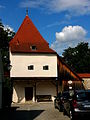
| Amtmannsdorf 22 ( location ) |
Catholic branch church of St. Nicholas | Late Romanesque choir tower , hall church with pitched roof, before 1415, extended to the west in 1896; with equipment | D-1-76-114-94 |
.JPG)
|
| Near Amtmannsdorf ( location ) |
Lady Chapel | Path chapel with open porch; 19th century, heavily renewed in recent times; with equipment ; on Wolfsbucher Weg | D-1-76-114-96 |

|
Arnbuch
| location | object | description | File no. | image |
|---|---|---|---|---|
| Arnbuch 8 ( location ) |
Schmauserhof | Farmhouse; Two-storey solid building with a lime slab roof, mid-19th century, plaster band structure and corner painting from more recent times | D-1-76-114-98 |

|
| Arnbuch 20 ( location ) |
Catholic branch church St. Rupert | Choir tower system in the core Romanesque, hall church with hipped roof, baroque style in the 18th century, extension of the nave and heightening of the tower in 1885; with equipment | D-1-76-114-97 |
.JPG) more pictures |
Ash book
| location | object | description | File no. | image |
|---|---|---|---|---|
| Agidiusstraße 6 ( location ) |
Catholic branch church St. Aegidius | Hall church with hipped roof, built in 1658, new building in 1717, tower in 1886; with equipment | D-1-76-114-99 |
.JPG) more pictures |
| Alte Zell, on the road to Eglofsdorf ( location ) |
Field chapel | Probably 18th century, recently heavily renewed | D-1-76-114-100 |
.jpg)
|
Biberbach
| location | object | description | File no. | image |
|---|---|---|---|---|
| Biberbach 114 ( location ) |
Catholic branch church St. Michael | Late Gothic choir tower , hall church with pitched roof, structurally changed in the 18th century, massive tower with arched openings in 1751; with equipment
Weir enclosure late medieval, with a stately gate tower |
D-1-76-114-101 |
 more pictures |
| Elendfeld ( location ) |
Wayside chapel | Mid 19th century; on the road to Gößelthalmühle | D-1-76-114-102 |
.jpg) more pictures |
| Wachtleite, on the street Litterzhofen-Plankstetten ( location ) |
Wayside shrine | Rock niche with a wooden tabernacle box in front, with a statuette of Our Lady, 19th century | D-1-76-114-160 |
.jpg)
|
Gösselthal
| location | object | description | File no. | image |
|---|---|---|---|---|
| Am Ludwigskanal 2 ( location ) |
Beilngries canal port | Beilngries canal port as part of the Ludwig-Danube-Main Canal, quay wall, 1836–45; Iron crane, 1836-45; Hafenmeisterhaus, two-storey solid building with flat gable roof, 1836–45; Goods shed, single-storey timber construction with flat gable roof, 1836–45. | D-1-76-114-170 |
 more pictures |
| Am Ludwigskanal 2 ( location ) |
Iron crane | 1836-45. | D-1-76-114-170 associated |
 more pictures |
| Am Ludwigskanal 2 ( location ) |
Harbor master's house | Two-storey solid building with flat gable roof, 1836–45. | D-1-76-114-170 associated |
 more pictures |
| Am Ludwigskanal 2 ( location ) |
Goods shed | Single-storey timber construction with flat gable roof, 1836–45. | D-1-76-114-170 associated |
 more pictures |
| Gösselthal 2 ( location ) |
Gösselthalmühle, former courtyard and mill, now the control center of the Ludwig-Danube-Main Canal | Two two-story pitched roof buildings at right angles to each other, 18th century, plaster and window frames from more recent times
Courtyard walling with crenellated gate entrance, marked with the year "1759" (not visible) |
D-1-76-114-104 |
 more pictures |
| Gösselthal 11, opposite the mill ( location ) |
Wayside chapel | First half of the 19th century | D-1-76-114-105 |
 more pictures |
| Rhine-Main-Danube Canal ( location ) |
Section of the Ludwig-Danube-Main Canal | Section of the Ludwig-Danube-Main Canal, an artificially created waterway between Kelheim and Bamberg over a length of 173 km with formerly 100 locks, numerous water and shipping systems and buildings to create a continuous waterway between the North Sea and the Black Sea, on request King Ludwig I of Bavaria by Heinrich Freiherr von Pechmann, 1836–45. | D-1-76-114-106 |
 more pictures |
| Rhine-Main-Danube Canal ( location ) |
Bridge channel | Bridge canal, with arched passage, natural stone, 1836–45. | D-1-76-114-106 associated |
 more pictures |
Grampersdorf
| location | object | description | File no. | image |
|---|---|---|---|---|
| Kirchstrasse 11 ( location ) |
chapel | small hall church with hipped roof and west tower, 1784; with equipment | D-1-76-114-107 |

|
| Kirchstrasse 12 ( location ) |
House 'Stoffelbauer' | former farmhouse; one and a half storey solid building with a plastered half-timbered gable and a renewed lime slab roof, built around 1720 ( dendrochronologically dated) | D-1-76-114-167 |
.jpg)
|
| Near the water tower ( location ) |
Wayside shrine | Bricked; 19th century | D-1-76-114-108 |

|
Hirschberg
| location | object | description | File no. | image |
|---|---|---|---|---|
| Hirschberg 70; Vineyard ( location ) |
Hirschberg Castle, former prince-bishop's hunting castle, diocesan retreat house since 1925, diocese house since 2003 | Elongated rectangular system on steeply sloping mountain ridge, in the core a late Romanesque hill castle, 1170–1200, with outer castle system, 15th / 16th century. Century, new buildings and renovations after fire in 1636/52? and 1729, remodeled into a summer residence and as a late baroque hunting lodge by Maurizio Pedetti , 1760–64, renovation and expansion by Karljosef Schattner , 1988–92; with equipment
Castle construction; Three-wing complex, three-storey hipped roof buildings, north wing, second half of the 16th century, extension around 1729, extension of the hall (east wing) by Jakob Engel after 1670, elevation, 1729, extension of the south wing and extension of the north wing by Gabriel de Gabrieli , around 1730 Redesign to a symmetrical palace complex with the creation of the court of honor, extension of the south wing and construction of the two gatehouses, two-storey hipped roof buildings, with baroque entrance, based on plans by Mauritio (Moitz) Pedetti, 1760–64 Furnishing of the interior (especially the palace chapel, imperial and knight's hall) by Johann Michael Franz and Johann Jakob Berg , second half of the 18th century Castle chapel St. Johann Evangelist, in the core 12th century, redesigned in Baroque style, 1764, extending over two floors, in the south wing New construction of the Marienkapelle, flat-roofed central building made of ashlar masonry over a heptagonal floor plan, by Alexander von Branca , 1967/69, integrated into the kennel on the south slope Castle complex, 13th to 15th centuries South tower, former gate tower, around 1200, with Gothic gable structure, with gatehouse and weir system, 13th century Northern tower, former keep, basement Romanesque, upper floor, 14th / 15th century century Parts of the ring walls in the north and south, in the core first half of the 13th century, reinforcement in the 14th / 15th. century Former count building, today a hall building, in the core of the 15th century, in the east Kennel complex in the south and north, 12th century, renewed in the 15th century, today preserved as terrace lining walls Neck ditch with fortification walls and bridge Outer bailey, trapezoidal complex with four towers and fortification walls, 15th / 16th centuries Century (see also house 2, 37, 38, 39, 43, 47); Ground floor wall tower with pyramid roof, so-called Pschorrturm, in the core of the second half of the 15th century, recently renewed, in the north Two-storey corner tower with a gable roof and half-timbered gable, essentially the second half of the 15th century, recently expanded into a residential building, with a fortification wall, northwest corner Two-storey fortification tower with pyramid roof, the core of the second half of the 15th century, converted into a residential building, 2001 ff., With fortification walls, in the west Two-storey wall tower with pyramid roof, the core of the second half of the 15th century, recently converted into a residential tower, with a fortification wall, in the south Former barn, now residential building, ground-floor saddle roof building made of quarry stone with half-timbered gable, first half of the 19th century, rebuilt and renewed, 1999–2001 Fortification walls in the north, west and south, second half of the 15th century, partially renewed after 2001 and the following years |
D-1-76-114-109 |
 more pictures |
| House 2 ( location ) |
Former fortification tower of the outer bailey | Second half of the 15th century, converted into a residential building
With fortification walls, at the same time, partly overbuilt; formerly part of the castle not re-qualified, not mapped in BayernViewer-denkmal |
D-1-76-114-109 associated
(formerly D-1-76-114-113) |

|
| House 37 ( location ) |
Fortification tower on the northwest corner of the outer bailey | Second half of the 15th century
Fortification walls, at the same time; formerly part of the castle not re-qualified, not mapped in BayernViewer-denkmal |
D-1-76-114-109 associated
(formerly D-1-76-114-115) |

|
| House 38 ( location ) |
Fortification tower, coat of arms | Coat of arms marked with the year "1556"
Barn, quarry stone building with half-timbered gable, first half of the 19th century, over the fortification wall of the outer bailey, second half of the 15th century Fortification tower of the outer bailey and attached fortifications, second half of the 15th century; formerly part of the castle not re-qualified, not mapped in BayernViewer-denkmal |
D-1-76-114-109 associated
(formerly D-1-76-114-116) |

|
| House 39 ( location ) |
Associated train of the fortification wall of the outer bailey | Second half of the 15th century; formerly part of the castle
not re-qualified, not mapped in BayernViewer-denkmal |
D-1-76-114-109 associated
(formerly D-1-76-114-117) |

|
| House 43 ( location ) |
Fortification tower of the outer bailey | Second half of the 15th century; Remains of the fortification walls, simultaneously; formerly part of the castle
not re-qualified, not mapped in BayernViewer-denkmal |
D-1-76-114-109 associated
(formerly D-1-76-114-118) |

|
| House 47 ( location ) |
Fortification tower of the outer bailey (Pschorrturm) | Second half of the 15th century; formerly part of the castle
not re-qualified, not mapped in BayernViewer-denkmal |
D-1-76-114-109 associated
(formerly D-1-76-114-119) |

|
| Hirschberg 70 a ( location ) |
Former bridle path, so-called Fürstenstraße | Today mostly asphalt road, 3.5 km long axis leading west from the castle courtyard, laid out by Moritz Pedetti in 1760/64 | D-1-76-114-110 |

|
| In Hirschberg ( location ) |
chapel | Small baroque building with a pitched roof, facade structure with pilasters and triangular gable, marked with the year "1713"; with equipment | D-1-76-114-111 |
 more pictures |
| At the Kappenbauer, on the Bergstrasse from Hirschberg to Beilngries, opposite the war memorial ( location ) |
Stone cross | Medieval | D-1-76-114-112 |

|
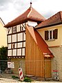
| Hirschberg 28 ( location ) |
Former farmhouse | Residential house, ground floor saddle roof building with rich half-timbered gable, first half of the 18th century, dormers from more recent times | D-1-76-114-114 |

|
| Haselfeld, on the road to Haunstetten ( location ) |
Johanneskapelle | Bricked, 18th century, recently renovated; with equipment | D-1-76-114-120 |

|
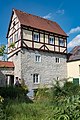
| Hirschberg 23 ( location ) |
Former farmhouse | Residential house, ground floor, solid construction with lime slab roof (renewed), with half-timbered knee and rich half-timbered configuration on the southern gable, the core around 1580 (dendrochronologically dated) | D-1-76-114-162 |

|
Irfersdorf
| location | object | description | File no. | image |
|---|---|---|---|---|
| Am Kirchplatz 1 ( location ) |
Catholic parish church St. Margaretha | Hall church with pitched roof, completed in 1437, nave redesigned in Baroque style in 1703 and 1715/16, upper floor of the tower in 1766; with equipment
Cemetery fortifications, medieval |
D-1-76-114-121 |
.JPG)
|
| At Kirchplatz 5, free-standing in the center of the village ( location ) |
Old Forge | former forge, now residential building; two-storey solid construction with lime slab roof and half-timbered gables, 18th / 19th centuries century | D-1-76-114-124 |
_Alte_Schmiede.jpg)
|
| Brunnfeld, on Feldweg ( location ) |
Wayside shrine | Bricked, 19th century, recently heavily renovated | D-1-76-114-126 |
_Bildstock_am_Feldweg.jpg)
|
| Kratzmühlstrasse 5 ( location ) |
Farmhouse | two-storey solid building with a pitched roof, first half of the 19th century, recently heavily renovated | D-1-76-114-122 |
_Bauernhaus_Kratzm%C3%BChlstra%C3%9Fe_5.jpg)
|
| Kratzmühlstraße 32, on the way to Pfraundorf ( location ) |
Wayside chapel | 18th century, recently heavily renewed; with equipment | D-1-76-114-125 |
_Kapelle.jpg)
|
| Kreisstraße 7 ( location ) |
Former small farmhouse | Ground floor residential stable house with knee floor and lime slab roof, partly with half-timbering, mainly around 1700, with a more recent dormer window | D-1-76-114-161 |
_Kreisstra%C3%9Fe_7.jpg)
|
| Kreisstraße 11 ( location ) |
Gasthaus zum Bären | former inn, now residential building; Two-storey, elongated solid building with lime-plate roof and semicircular arched window in the gable, mid-19th century | D-1-76-114-123 |
_Gasthaus_zum_B%C3%A4ren_2.jpg)
|
| Oberemmendorfer Weg, on Oberemmendorfer Weg ( location ) |
Wayside shrine | Bricked, 19th century, recently renovated | D-1-76-114-127 |
_Bildstock_am_Oberemmendorfer_Weg.jpg)
|
Kevenhüll
| location | object | description | File no. | image |
|---|---|---|---|---|
| Kevenhüller Moos ( location ) |
Lock 22 | Part of the Ludwig-Danube-Main Canal, chamber lock, natural stone, 1836–45. | D-1-76-114-171 |
 more pictures |
Church book
| location | object | description | File no. | image |
|---|---|---|---|---|
| Church book 1 ( location ) |
Catholic Parish Church of St. Blaise | Hall church with pitched roof, Gothic core, rebuilt 1924–26, former choir, now Gothic side chapel and tower; with equipment ;
The core of the cemetery wall is medieval, recently renewed Wrought iron grave cross on a stone base in the former cemetery, mid-18th century |
D-1-76-114-134 |
.JPG) more pictures |
| Church book 2 ( location ) |
Parish barn | Bricked and in half-timbered, with a limestone roof, probably from the 18th century | D-1-76-114-135 | |
| Near Grampersdorfer Weg, on the road to Aschbuch ( location ) |
Wayside shrine | Bricked; 19th century, recently renewed | D-1-76-114-136 |
.jpg)
|
Kottingwörth
| location | object | description | File no. | image |
|---|---|---|---|---|
| Alte Salzstrasse 13 ( location ) |
Catholic parish church of St. Vitus | Baroque double tower system on the medieval basis of a fortified church, hall church with pitched roof built in 1760–61 according to plans by Giovanni Domenico Barbieri, western tower in the core around 1250, eastern tower around 1310, both upper floors 16th century, onion domes 1761, with Vitus chapel; with equipment
Cemetery, formerly fortified, with gate tower with stepped gable and wall ring, late medieval |
D-1-76-114-137 |
 more pictures |
| Alte Salzstrasse 15 ( location ) |
Rectory | Two-storey gable building with flat gable roof, marked with the year "1622" by a coat of arms, renewed 1992–93 | D-1-76-114-138 |
 more pictures |
| Alte Salzstrasse 21 ( location ) |
Utility building of the former farm, so-called Trefferstadel | Ground floor massive quarry stone building with lime slab roof, arched gate entrances and ventilation hatches, late 18th / early 19th century, lime paint from more recent times | D-1-76-114-139 |
_Trefferstadel.jpg)
|
| Alte Salzstrasse 32 ( location ) |
Former farm building | Two-and-a-half-story solid building made of quarry stone masonry with a lime slab roof, probably from the end of the 18th century over an older core, plaster from more recent times | D-1-76-114-166 |
_Stadel.jpg)
|
| Dietfurter Straße 16, in the garden of house no.16 ( location ) |
Pillar of torture | Square pillar with ogival closed niche and cross, marked with the year 1494, with a coat of arms in relief (fish and horseshoe) | D-1-76-114-141 |
_Marters%C3%A4ule.jpg)
|
| In Kottingwörth ( location ) |
Stone cross | Medieval, probably; at the Altmühlbrücke | D-1-76-114-143 |
 more pictures |
| In Kottingwörth, beyond the Altmühl ( location ) |
Wayside shrine | Square stone pillar with an ogival niche top, 16./17. Century, with coat of arms (fish and horseshoe) | D-1-76-114-142 |
 more pictures |
| District road EI 24 ( location ) |
Stone pillars | 18th century; at the junction Kottingwörther Mühle | D-1-76-114-140 |
 more pictures |
Leising
| location | object | description | File no. | image |
|---|---|---|---|---|
| Leising 3 ( location ) |
Farmhouse | Broad, ground floor solid building with lime slab roof, first half of the 19th century; northern part built into the slope | D-1-76-114-145 |
_Bauernhaus.jpg)
|
| Leising 9 ( location ) |
Catholic branch church St. Michael | Hall church with pitched roof and choir tower, end of the 17th century; renovated 1966–67 and 1989; Facade painting with staggered pilasters and triglyph frieze from more recent times; with equipment | D-1-76-114-144 |
_St._Michael_1.jpg) more pictures |
Oberndorf
| location | object | description | File no. | image |
|---|---|---|---|---|
| Oberndorf 7 ( location ) |
Farmhouse | One-and-a-half-storey solid building with a high knee and plaster band structure, 19th century | D-1-76-114-149 |
_7.jpg)
|
| Oberndorf 8 ( location ) |
Catholic branch church St. Maria | Hall church with pitched roof and ridge turret, newly built in 1834; with equipment | D-1-76-114-148 |
_St._Maria_1.jpg)
|
| Oberndorf 10 ( location ) |
Farmhouse | One-and-a-half-story solid building with a high knee and lime slab roof (renewed), with plaster band structure, 19th century | D-1-76-114-150 |
_10_1.jpg)
|
Paulushofen
| location | object | description | File no. | image |
|---|---|---|---|---|
| Dorfstrasse 9 ( location ) |
Former farmhouse | Ground floor, gable-sided residential barn building with knee floor and lime slab roof, essentially the second half of the 15th century (dendrochronologically dated 1467/68), renewed around 1930 within the original structures and extended by transverse barns
Barn, timber-framed post construction with a brick base, central antenna and limestone roof, mid-18th century (dendrochronologically dated 1743/44) |
D-1-76-114-165 |
.jpg)
|
| Dorfstrasse 28 ( location ) |
Catholic parish church of St. Pauli Conversion | Hall church with pitched roof, west facade with curved gable, nave while retaining the Gothic choir tower built by Gabriel de Gabrieli 1722–23, tower and sacristy renewal in 1904; with equipment
Cemetery gate, with ball attachments, early 20th century |
D-1-76-114-151 |

|
| Forststraße 1 ( location ) |
Wayside chapel | Gable roof construction with a small porch, 18th century, recently renovated | D-1-76-114-152 |
_01.jpg)
|
Wiesenhofen
| location | object | description | File no. | image |
|---|---|---|---|---|
| Wiesenhofen 3 ( location ) |
Farmhouse | Ground floor in the core 1681 (dendrochronologically dated), structure with knee-high and gable in half-timbered construction with pitched roof, renewed in 1932 | D-1-76-114-155 |

|
| Wiesenhofen 18 ( location ) |
Catholic branch church of the Visitation of the Virgin Mary | Early Gothic choir tower church , hall building with hipped roof, extended and raised in 1884; with equipment | D-1-76-114-154 |
 more pictures |
| Wiesenhofen 29 ( location ) |
Chapel of St. Sebastian | Marked with the year "1847"; with equipment | D-1-76-114-156 |

|
Wolf book
| location | object | description | File no. | image |
|---|---|---|---|---|
| Fuchsengasse 6a ( location ) |
Former inn and farmhouse | Two-storey solid construction with a high knee and lime slab roof, first half of the 19th century | D-1-76-114-158 |

|
| Kirchgasse 11 ( location ) |
Catholic parish church of St. Andrew | Hall church with hipped roof, core 15th century, expansion 1884/86, tower Romanesque; with equipment ;
Cemetery chapel, second half of the 19th century (?), Cemetery walling, probably medieval core, recently renewed |
D-1-76-114-157 |
.JPG)
|
Further districts
| location | object | description | File no. | image |
|---|---|---|---|---|
|
Eglofsdorf 1 ( location ) |
Catholic branch church St. Martin | Hall church with pitched roof, new building in the 17th century including the Romanesque choir tower ; with equipment | D-1-76-114-103 |

|
|
Kaldorf , Grundfeld, on the road to Hirschberg ( location ) |
Limestone pillars | 18./19. Century, "naive" painting from more recent times | D-1-76-114-129 |
_Bildstock.jpg)
|
|
Kevenhüll A35 ( location ) |
Catholic parish church of St. Ulrich |
The core of the choir tower is medieval, a hall church with a pitched roof, a new nave based on plans by Giovanni Domenico Barbieri 1739–52, the tower around 1308; with equipment
Cemetery fortifications, parts of the medieval wall ring preserved |
D-1-76-114-130 |
.JPG) more pictures |
| From the front to the rear Mandlachfeld, in the Mantlacher Holz forest area ( location ) |
Wayside shrine | Limestone pillars, 19th century, empty niche | D-1-76-114-128 |
.jpg)
|
|
Litterzhofen 23 ( location ) |
Catholic branch church St. Wolfgang | Gothic complex, 15th century, hall church with pitched roof, reconstruction in 1706, extended in 1922; with equipment | D-1-76-114-146 |
 more pictures |
|
Neuzell ( location ) |
St. Mary's Chapel | Small hall building with pitched roof and ridge turret, 1794, recently renewed; with equipment | D-1-76-114-147 |
.JPG)
|
| Pfenninghof 1 ( location ) |
Holy Trinity Chapel | Small steep roof building, facade structure with pilasters and triangular gable, marked with the year "1704", renovated in 1999; with equipment | D-1-76-114-153 |
_Kapelle.jpg)
|
| Utzmühle 1 ( location ) |
Former operating and residential building of the Utzmühle, built as a pumping station for the water supply, later converted into a power station for electricity generation, today a residential building | two-storey pitched roof building to the east with forehead, protruding upper storey bay window in the reduced Heimat style, 1910/11, east engine extension at the same time;
With technical equipment as well as water supply and outlet devices Former barn, now a residential building, two-storey pitched roof building with a former stable wing attached to the south, 18th / 19th centuries century Wash house, 1910/11, with renewed lime slab roof, 1999 |
D-1-76-114-159 |
.jpg)
|
Former architectural monuments
This section lists objects that were previously entered in the list of monuments.
| location | object | description | File no. | image |
|---|---|---|---|---|
| Beilngries Ingolstädter Straße 1b, at No. 2 ( ) |
chapel | Modern; with historical equipment; not findable (2020-04-11); canceled? | D-1-76-114-60 | |
| Beilngries Mittelmühlweg 5 ( ) |
Door frame | Limestone and front door, end of the 18th century | D-1-76-114-68 | |
| Beilngries near Zinngießergasse ( ) |
Residential building | Gable construction with irregular pent roof extensions, second half of the 18th century | D-1-76-114-93 | |
| Beilngries Stadtgraben 1 ( location ) |
Defense tower | Rebuilt as a residential house, with a half-timbered upper part, 18th century, on an older basis (now listed under city fortifications, D-1-76-114-1) | D-1-76-114-87 | |
| Beilngries Stadtgraben 29 ( location ) |
Associated parts of the city wall | 15th century (now listed under city fortifications, D-1-76-114-1) | D-1-76-114-89 | |
| Beilngries Stadtgraben 32 ( location ) |
Associated parts of the city wall | 15th century (now listed under city fortifications, D-1-76-114-1) | D-1-76-114-90 | |
| Amtmannsdorf Amtmannsdorf 19 ( location ) |
Farmhouse | Ground floor eaves side building with knee floor and lime slab roof, first half of the 19th century; obviously demolished and replaced by a modern residential building (viewing 2020-04-13) | D-1-76-114-95 | |
| Kevenhüll Kevenhüll A 29 ( location ) |
Farmhouse | On the ground floor, with a high knee and lime slab roof, first half of the 19th century | D-1-76-114-132 |
See also
Remarks
- ↑ This list may not correspond to the current status of the official list of monuments. The latter can be viewed on the Internet as a PDF using the link given under web links and is also mapped in the Bavarian Monument Atlas . Even these representations, although they are updated daily by the Bavarian State Office for Monument Preservation , do not always and everywhere reflect the current status. Therefore, the presence or absence of an object in this list or in the Bavarian Monument Atlas does not guarantee that it is currently a registered monument or not. The Bavarian List of Monuments is also an information directory. The property of a monument - and thus the legal protection - is defined in Art. 1 of the Bavarian Monument Protection Act (BayDSchG) and does not depend on the mapping in the Monument Atlas and the entry in the Bavarian Monument List. Objects that are not listed in the Bavarian Monument List can also be monuments if they meet the criteria according to Art. 1 BayDSchG. Early involvement of the Bavarian State Office for Monument Preservation according to Art. 6 BayDSchG is therefore necessary in all projects.
literature
- Wilhelm Neu, Volker Liedke: Upper Bavaria . Ed .: Michael Petzet , Bavarian State Office for the Preservation of Monuments (= Monuments in Bavaria . Volume I.2 ). Oldenbourg, Munich 1986, ISBN 3-486-52392-9 .
Web links
- List of monuments for Beilngries (PDF) at the Bavarian State Office for Monument Preservation
- Bavarian Monument Atlas (cartographic representation of the Bavarian architectural and ground monuments by the Bavarian State Office for Monument Preservation (BLfD) )

Adelschlag | Altmannstein | Beilngries | Böhmfeld | Buxheim | Denkendorf | Dollnstein | Egweil | Eichstätt | Eitensheim | Gaimersheim | Großmehring | Hepberg | Hitzhofen | Kinding | Kipfenberg | Koesching | Lenting | Mindelstetten | Mörnsheim | Nassenfels | Oberdolling | Pförring | Pollen field | Schernfeld | Stammham | Titting | Walting | Wellheim | Wettstetten