
List of architectural monuments in Eichstätt
The monuments of the Upper Bavarian district town of Eichstätt are compiled on this page . This table is a partial list of the list of architectural monuments in Bavaria . The basis is the Bavarian Monument List , which was first drawn up on the basis of the Bavarian Monument Protection Act of October 1, 1973 and has since been managed by the Bavarian State Office for Monument Preservation . The following information does not replace the legally binding information from the monument protection authority.


Architectural monuments according to districts
Ensemble of the old town of Eichstätt

The episcopal town of Eichstätt is located in the narrow Altmühltal, bordered by steep slopes and Jura limestone walls, at a river knee that wraps around a mountain tongue. The square of the old Eichstätter Bischofsburg, the Willibaldsburg, dominates the rest of the cityscape and the valley landscape. Settlements from the Celtic and Roman times were found primarily in the area of the cathedral, near the probably very old ford through the Altmühl. In the vicinity of Eichstatt there were Roman military camps (Pfünz, Weißenburg) and not far to the north the Limes secured the northern border of the Roman province of Raetia. A west-east Roman road on the left edge of the valley should have particularly favored the later west-east expansion of the city in addition to the constraint of the topographical location.
St. Willibald, an Anglo-Saxon and relative of St. Boniface, founded "Eihstat", one of the main towns in the Bavarian Northern Gau, around 741 in an area where the Franconian, Bavarian and Alemannic tribe penetrated and in the border area between Franconian and Bavarian interests a mission monastery. If this foundation was certainly also initiated by the Bavarian Duke, the bishop's seat was set up at this monastery in 744/45, shortly after the defeat of the Bavarian duke by the Franconian house keepers, undoubtedly in Franconian interests, as a base against Bavaria.
The excavations in 1970/72 uncovered traces of the monastery and the church buildings of the first bishop Willibald. In the 11th century, the early Romanesque cathedral, consecrated in 1060, with the cathedral monastery and the bishop's palace on the south side and the cathedral cemetery and a baptistery on the north side rose on top of these remains from the 8th to 10th centuries. Within an oldest inner ring, given on the south side by the banks of the Altmühl, closed around the cathedral district since 10/11. Century episcopal official buildings, economic buildings of the monastery, Canon Curia with their own fortification towers and some older chapels. By the end of the 12th century, this cathedral city, which was fortified after 908 and given market and minting rights, had been expanded by a second outer ring of canon curiae. This step-by-step expansion of the cathedral city is still clearly visible in the city plan; In outline, the reconstruction and the baroque redesign after the Thirty Years War strictly preserved the spiritual character of this district.
In the 11th / 12th In the 19th century, in front of the north gate of the cathedral city, probably instead of an older merchant settlement, the town center developed in a relatively small area. This was laid out according to plan with rows of town houses along less northwest-southeast facing streets and on the sides of the triangular market square. The southern part of the market square with the parish and collegiate church, founded in 1022 and demolished in 1818, originally belonged to the cathedral city. As early as the 12th century, the bourgeois settlement reached out along the narrow banks of the Altmühl to the northwest, formed the oldest of the Eichstätt suburbs, the Westenvorstadt, and brought the large Benedictine monastery, which was already on the slope and was built in 1035 above the burial place of St. Walburga, into the Urban space. In 1199, the cathedral city, Bürgerstadt, Westenvorstadt and the Walburgakloster were enclosed by a common wall.
Church and monastery of St. Walburga, the sister of St. Willibald, developed into an important pilgrimage; the buildings set the most important urban accent in the cityscape after the cathedral. The high and late medieval expansion of the city is illustrated in the redesign of the Romanesque cathedral to a Gothic double-choir hall in the 14th century, in the establishment of the Dominican monastery in 1271 on the eastern edge of the town. in the establishment of the hospital in 1230 in front of the western head of the Altmühlbrücke and the construction of the civil town hall in 1444 on the market square. Further suburban training courses are also available in the 13th / 14th centuries, given the limited space in the walled city. Century emerged as open suburbs. The Ostenvorstadt grew into the Schottenkloster, founded in the 12th century, which was converted into a Capuchin monastery at the beginning of the 17th century, and in 1534 housed the new large east cemetery. The Sebastians- and Frauenbergvorstadt unfolded in front of the small Spitalvorstadt to the right of the Altmühl. Kugelberg, Schießstätt and Buchtalvorstadt only emerged in the 17th and 18th centuries. Century in the northeast of the town in partly sloping terrain. For all suburbs, perhaps as early as the late Middle Ages, but certainly after the Thirty Years War, the gabled residential buildings in the characteristic Altmühljura construction, originally with lime-plate roofs, became mandatory. This type of construction, mostly village-like in the suburbs, also prevailed in the bourgeois buildings of the inner city until other baroque house types appeared alongside them in the 18th century.
After major destruction in 1634, the rich century of reconstruction and the baroque redesign of Eichstatt into a prince-bishop's capital and residence between 1670 and around 1790 shaped the cityscape. The first baroque intrusion into the medieval city structure meant the establishment of the Jesuit church and the college since 1614 on the south-eastern edge of the cathedral city. The three great Baroque master builders Eichstätts, Jakob Engel, Gabriel de Gabrieli and Maurizio Pedetti , on the other hand, proceeded largely on the basis of older structures when they created canon courts and prince-bishop's offices around the cathedral, on Roßmarkt and on Leonrodplatz. The highlights of this redesign were the Baroque cathedral west facade Gabrielis and the residence Engels, Gabrielis and Pedettis on the south side of the cathedral, whose forecourt became one of the most beautiful baroque squares in Germany.
The Walburgakloster in the west suburb had already been renovated in baroque style in the 17th century, in the east suburb Gabrielis Notre-Dame-Kloster and the prince-bishop's summer residence with the court garden set new accents in the cityscape. The architectural structures and decorative forms of the Baroque and Rococo also penetrated into the inner city, but the bourgeois house had to hold on to the flat-gabled limestone roof, while the prince-bishop's and noble buildings had tiled hip and mansard roofs. This differentiated roof landscape is just as characteristic of Eichstätt as the largely undisturbed harmony of the historical urban landscape and the natural landscape. File number: E-1-76-123-1.
City fortifications of Eichstätt
The first walling of the cathedral city can only be seen in the city plan. The remaining trains of the Bering, which enclosed the cathedral city, township and Walburga monastery around 1200, were renewed several times, partially reduced and the tower crowns changed in the 19th century. The fortification of the west suburb was built around 1400. The bay gate and the inner west gate were demolished in 1816, the east gate and the hospital gate in 1817, and the outer west gate in 1831.
The following are preserved:
on the west side parts of the fortification formerly surrounding the west suburb:
- medieval defense tower (Fuchsbräugasse 3) ( location )
- Battery tower, former roundabout (Westenstrasse 31), fragment ( location )
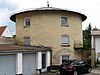
- Batterieturm, former roundabout in front of the former Westentor (Westenstrasse 91), around 1460, expanded as a three-story residential building since 1865 ( location )
- Round tower of the monastery walling of St. Walburg (Walburgiberg 6/8), 15./16. Century ( location )
- Wall move from the former Westentor (Westenstraße 82) ( location ) encompassing Kapellbuck to the round tower of the monastery walling of St. Walburg, 15th century
- a wall remnant with high water mark from 1784 (between Westenstrasse 43 and 47)
- a wall remnant between Westenstrasse 42 and 44 ( location )
- a wall section beginning at Westenstrasse 40/44 at the round tower of Walburgiberg 6/8 connected to the west suburb walling and kinking to the east up to the extension of the monastery garden (see Walburgiberg 6/8) reaching ( location )

Defense tower Fuchsbräugasse 3
Batterieturm, former roundabout, Westenstrasse 91
Round tower of the monastery wall of St. Walburg
.jpg)

on the north side:
- a long northern wall procession, 13./14. Century, partially reduced in 1877, with four fortification towers and remains of the late medieval kennels, 13th / 14th centuries. Century and early 15th century, which extends from the Walburgakloster to the former Buchtaltor (Walburgiberg 6/8, Webergasse, Am Zwinger) ( location )
- so-called garden tower near St. Walburg (behind Webergasse 36/38) ( location )
- Scharwachtturm (Walburgiberg 6/8) ( location )
- so-called Zwingerturm (Am Zwinger 3) ( location )
- Tower at the former Fronfeste between Webergasse and Am Zwinger 4 ( location )
- former kennels, 13./14. Century and early 15th century (Am Zwinger 4, 7/9) ( location )

northern wall with four towers

Garden tower


on the east side:
- Remains of kennels, weir keep and wall train with fortification towers between Salzstadel and the former Buchtaltor (Am Graben 11, 21, Luitpoldstraße 8, 10/12, Wohlmuthgasse 2) ( location )
- Wehrerker (Am Graben 11) ( location )
- Half tower (Am Graben 9) ( location )
- Tower (Am Salzstadel 4 / Am Graben 11) ( location )
- Tower (in the Wohlmuthgasse 2 area), late medieval, with a baroque crenellated crown and gate passage from 1869 ( location )
- Tower (at the garden house at Luitpoldstrasse 2) ( location )
- Tower fragment (Luitpoldstrasse 10/12) ( location )
- Tower (between Kardinal-Preysing-Platz 3 and the garden of Luitpoldstraße 8) ( location )
- Kennels (Am Graben 21) ( location )

Wehrerker Am Graben 9
Half tower Am Graben 11

Tower Luitpoldstrasse 8
Tower in the Wohlmuthgasse 2 area


in the south:
- Remnants of the wall and three fortification towers behind Residenzplatz 16, 18/30 and behind Leonrodplatz 5 ( location )
- Jakob tower at the seminary (behind Leonrodplatz 5) ( location )
- So-called Gärtnerturm (behind Residenzplatz 18, 30) ( location )
- Tower (behind Residenzplatz 16) ( location )

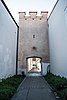
Jacob Tower

File number: D-1-76-123-1
| location | object | description | File no. | image |
|---|---|---|---|---|
| At the kennel 2; At the kennel 4; At the kennel 7; Near Am Zwinger ( location ) |
Courtyard gate | Part of the former kennel complex with a courtyard gate from the 18th century (see city fortifications). | D-1-76-123-19 |
 more pictures |
| At the kennel; At the kennel 7; Am Zwinger 9 ( location ) |
Old barracks | So-called old barracks and former customs office, a complex of three adjoining buildings, set diagonally to the west in front of the city wall, No. 9, the eastern originally two-story, later raised three-story flat hipped roof building, forms with the southern part of No. 7, which is in alignment with it the northern end of the Zwingerplatz as an elongated building, set up in the middle of the 17th century, 1786–1806 as a "Soldiers-Arrestanten-Haus" or "Stockhaus"; the southern or front part of No. 7 is two-storey with a flat gable roof, the oldest datable stands dendrologically dated around 1646, all others dendrologically dated around 1700; the north part of no. 7, which was subsequently added parallel to the first, is a two-storey residential and workshop building facing the economy courtyard, with a gable roof, dendrologically dated 1701/02, renovations in the 20th century; in the courtyard to the west, barn with two courtyard gates, 18th century (see also city fortifications). | D-1-76-123-20 |
 more pictures |
| Fuchsbräugasse 3 ( location ) |
Defense tower | Medieval defense tower of the city fortifications (see also there), surrounded by a house from the 18th century. | D-1-76-123-71 |
.jpg) more pictures |
| Westenstrasse 45/47 ( location ) |
Remnants of the city wall with high water mark | Medieval remains of the city wall with high water mark from 1784; between house number 45 and 47. | D-1-76-123-284 |
 more pictures |
Eichstatt
| location | object | description | File no. | image |
|---|---|---|---|---|
| Am Graben 17 ( location ) |
Residential building | Hipped roof construction with gable projections and plaster structures, built in 1890/91; Inside, rich decorative paintings using stencil technique, around 1900. | D-1-76-123-366 |
 more pictures |
| Am Graben 26 ( location ) |
Former monastery school | Former monastery school of Notre Dame (or schoolhouse of the external), now the second Evangelical-Lutheran rectory; Angled two-storey building with a gently sloping hipped roof and plaster structure, by Gabriel de Gabrieli , dendrologically dated 1724 (see also: Notre Dame Monastery, Notre Dame 1 and Kardinal-Preysing-Platz 8-14). | D-1-76-123-11 |
 more pictures |
| Am Graben 32 ( location ) |
Former craftsman's house | Former craftsman's house (weaver's house), gable-independent, flat-saddle roof building with half-timbered knee - height , leaning on the back against the retaining wall of the Kugelberg , built around 1700, renovated after the middle of the 18th century with lining of the former half-timbered upper floor while preserving the plank beam ceiling from the time of construction, renovation around 1970. | D-1-76-123-400 |
.jpg) more pictures |
| Am Graben 34 ( location ) |
Former town farmhouse | Gable-independent flat gable roof building, two-storey with plastered half-timbered knee floor and former threshing floor entrance on the gable side, extended over the ground floor from the late 17th century around 1792 (upper storey and roof dendrologically dated), simplified in the 20th century (renovations 1925 and around 1960). | D-1-76-123-401 |
.jpg) more pictures |
| Am Graben 36 ( location ) |
Agricultural bourgeoisie | Gable-side in Jura construction, with lime-slab roof, two-storey with knee-length floor, ground floor dendrologically dated around 1627–1634, lintel marked with the year 1635, roof structure dendrologically dated 1688, in the two-storey porch with pent roof shop window from the late 19th century. | D-1-76-123-12 |
 more pictures |
| Am Kugelberg ( location ) |
Former cathedral garden | Walled and terraced complex, probably redesigned in the last quarter of the 18th century, with a flight of stairs and three small pavilions; on the southern slope of the Kugelberg above house no.37 and 39. | D-1-76-123-389 |
.jpg) more pictures |
| Am Kugelberg 1 ( location ) |
Residential building | In Jura design, two-storey with a knee-high base, on the gable side with a straight two-flight flight of stairs and a sandstone portal with a baroque skylight, first half of the 18th century, probably on an older core. | D-1-76-123-14 |
 more pictures |
| Am Kugelberg 2 ( location ) |
Residential building | In the Jura style, small single-storey gable-independent building, marked with the year 1744. | D-1-76-123-15 |
 more pictures |
| Am Kugelberg 8 ( location ) |
Small two story house | In Jura construction, with a lime-plate roof at the gable, dendrologically dated around 1721, formerly horizontally divided with separate external closings of both floors according to the slope situation. | D-1-76-123-367 |
 more pictures |
| Am Kugelberg 31 ( location ) |
Former garden shed | Small solid building built into the steep slope with partially exposed basement, flat hipped roof and lime slab covering, built as part of the neighboring former canon garden at the end of the 18th century, later expanded for residential purposes. | D-1-76-123-463 |
.jpg) more pictures |
| Am Kugelberg 39 ( location ) |
Former town farmhouse | In the Jura construction, on the gable end, two-storey with a knee-high floor and a gently sloping gable roof, arched windows, first half of the 18th century. | D-1-76-123-16 |
 more pictures |
| Am Salzstadel 2 ( location ) |
Residential building | With a large passage through the courtyard, upper floors in half-timbering, plastered, lime slab roof, probably 18th century; structurally connected with No. 3. | D-1-76-123-18 |

|
| Am Salzstadel 3 ( location ) |
Farm building and workshop | Gable-mounted two-storey plastered solid construction with knee-high and flat sloping gable roof, the openings under the preserved crane boom changed around 2000, marked with the year 1768 on the wide arched entrance gate. | D-1-76-123-17 |
 more pictures |
| Am Salzstadel 6 ( location ) |
Former warehouse | Gable-independent saddle roof construction with crane boom over elevator hatches converted into windows, probably 17th century, upper floor expanded around the middle of the 19th century, renovation 2008. | D-1-76-123-369 |
 more pictures |
| On the Schellenberg; On the Willibaldsburg; Burgstrasse 19; Near Willibaldsburg ( location ) |
Willibaldsburg | Today the Law Museum; elongated castle complex on a mountain tongue, surrounded by fortification belts, founded in 1355 by Prince-Bishop Berthold, converted into a museum by Karljosef Schattner from 1973–1976 ; Vorburg: First facility at the end of the 14th century, gate construction with stables connected to the north, beginning of the 17th century, based on the 14th to 16th century, former hospital, probably 17th century, expanded in 1784 by Maurizio Pedetti as a penitentiary (two mansard roofs), former penitentiary chapel, rotunda, also by Pedetti; former armory, large rectangular building north of the gatehouse, second quarter of the 17th century; Foam mining (middle part of the castle), formerly (until 1870) four-sided closed complex, remnants of the building on the northeast side with bay window preserved, around 1575, now Burgschänke; at the back remains of the Dirlitz tower, late medieval; Gemmingenbau (western part of the castle), high renaissance complex based on plans by Elias Holl in 1609 and subsequent years, three-wing building closed around an inner courtyard, main wing in the west with two-tower front on the valley side (before 1829 with another upper floor and tower upper floors with onion domes), south wing with late-floor courtyard arcades in the middle, north wing , marked with the year 1495, shield wall in the east from the late Middle Ages; Fastening belt; Trenches, kennels, bastions (Schellenberg bastion and blacksmith bastion in the east, Hofmühl bastion and north bastion in the west), circular walls, curtains, lunettes, 14th to early 18th century | D-1-76-123-46 |
 more pictures |
| Antonistraße 1 ( location ) |
Stone figure | Figure of St. Anthony, late Gothic stone figure, 15th century, originally in the Capuchin monastery, placed here in the middle of the 20th century. | D-1-76-123-441 |

|
| Antonistraße 2 ( location ) |
Former summer cellar of the "Bummerlbräu" | Elongated cellar system, divided into three sections, with slightly flattened quarry stone barrel vault, probably 17th century, before 1721, on the former cellar building arched sandstone gate walls, around 1800, above it a stone tablet with the brewing coat of arms, inscribed with the year 1828. | D-1-76-123-21 |

|
| Antonistraße 4; Antonistraße 6; Antonistraße 8 ( location ) |
Former economic building of the Notre Dame monastery | Originally consisting of a barn (no. 4), stable (no. 6) and residential building of the economic manager (no. 8), stately two-storey, closed eaves-type complex in Jura construction with a large, arched barn door, 1721–1727, probably by Giovanni Domenico Barbieri , during renovation The stable building was converted into a residential building in 1966, the backs of No. 4 and No. 6 were heavily reshaped. | D-1-76-123-22 |

|
| Antonistraße 31 ( location ) |
Residential building | Jurassic construction, independent of the gable, two-storey with extended knee-length, originally with three entrance doors for each storey without internal staircase connection, on the core of the 17th century, baroque front door in stone walls with lead-glazed skylight, above it a relief of Mary as Queen of Heaven in a halo, 18th century. | D-1-76-123-24 |
 more pictures |
| Antonistraße 41 ( location ) |
"Pfarrstiftszehentstadel" | Former Zehentstadel, at the gable end with a lime slab roof, quarry stone masonry on the upper floor reinforced by an internal framework, first half of the 18th century. | D-1-76-123-370 |
 more pictures |
| Antonistraße 53 ( location ) |
Residential building | In Jura construction, ground floor with half-timbered knee floor, before 1796. | D-1-76-123-25 |

|
| Antonistraße 59 ( location ) |
Organ workshop | Broad, three-part building, single-storey eaves central part with workshop, two-storey gable end buildings with sloping gable roofs (to the west of the studio, to the east of the residential building) attached to the gable side of the central building, 1900. | D-1-76-123-26 |
 more pictures |
| Aumühle ( location ) |
Aumühlbrücke | With three barrel vaulted yokes, limestone, 1781; Bridge figure of St. Johann Nepomuk, at the same time, by Ignaz Alexander Breitenauer ; In 1977 a fourth yoke was added. | D-1-76-123-27 |
 more pictures |
| Aumühle 4 ( location ) |
crossroads | Opposite Aumühle, larger than life wooden cross with iron roof, end of the 19th century. | D-1-76-123-456 |

|
| Aumühle 7 ( location ) |
Mill building | In the core 16./17. Century, marked by Wappenstein with the year 1538, door frames marked with the year 1725, expanded into a three-storey art mill in 1922, today a sawmill; arched door walls and limestone roof, 17th / 18th centuries Century, painted windows and oval windows on the knee, 18th century. | D-1-76-123-28 |
 more pictures |
| Bahnhofplatz 1 ( location ) |
Holy Spirit Hospital Church | Early Baroque wall pillar construction with a gable roof, built by Giovanni Giacomo Engl from 1698–1703 , in structural unit with the four-storey hospital building (new building in historical form), the former stone gable turret replaced by a wooden one in 1834; with equipment . | D-1-76-123-29 |
 more pictures |
| Bahnhofplatz 12 ( location ) |
Steep gabled house | East of the former fishing settlement, quarry stone and half-timbered construction, in the middle of the 17th century; Limestone relief with the Annunciation, inscribed with the year 1704, in the wall of the house. | D-1-76-123-30 |
 more pictures |
| Bahnhofplatz 13 ( location ) |
Residential building | Former gunsmith's property, two-storey, gable-independent flat gable roof building in Jura construction with knee stick, lime slab roof, door frame numbered 1735, the core is older. | D-1-76-123-471 |
.jpg) more pictures |
| Bahnhofplatz 17 ( location ) |
Station building | Two-storey wing with corner pavilions and hipped roof, neo-baroque, built 1898–1900; Goods hall in solid construction with loading ramp and office in wood construction under a shared flat pitched roof, 1898–1900. | D-1-76-123-31 |
 more pictures |
| Brodhausgasse 1 ( location ) |
Community center | Three-storey, cantilevered over the first floor, eaves with a double gable, with a pointed arch portal and step ascent on the side of Marktplatz 9, late medieval, probably dendrologically dated in 1453, half-timbered restoration from 1988–1989. | D-1-76-123-33 |
 more pictures |
| Buchtal ( location ) |
Chapel of the Holidays | Catholic chapel Mariä Urlaub, small baroque gable building, around 1700; with equipment | D-1-76-123-38 |

|
| Buchtal 1 ( location ) |
Residential building | Narrow gable-independent corner house in Jura construction with lime slab cover, two-storey with knee-height, built in the late 17th century (roof structure dendrologically dated 1680), eaves-side shop extension with pent roof and renovation of the interior work in 1865. | D-1-76-123-371 |
 more pictures |
| Buchtal 2 ( location ) |
Community center | In the Jura construction, two-storey with a knee-length floor, probably early 18th century, the front door and door frames from the 18th century covered by a flat stand porch from 1897, from which time there were also further major remodeling as well as the installation of the house chapel, the building, the furnishings and the property fence Fundamentally renewed in 1977. | D-1-76-123-34 |

|
| Buchtal 5 ( location ) |
Community center | In Jura construction, on the gable, two-storey with knee-length floor, formerly marked with the year 1715, probably on the older core, Art Nouveau plastered facade and shop fitting of the first floor in 1906/07. | D-1-76-123-35 |

|
| Buchtal 12 ( location ) |
Residential building | Former nail smith's property, gable-independent corner house with the eaves facing Sonnenwirtsgässchen, originally vertically divided semi-detached house, upper floor and extended knee floor in plastered half-timbering, with lime-plate roof, around 1700. | D-1-76-123-372 |

|
| Buchtal 16; Buchtal 20 ( location ) |
Former inn | Former inn "Zum Stern", eaves residential building (no. 16), flat saddle roof building with a wide dwelling, attic floor 1678 ( dendrochronologically dated to), changed in 1849, front door walls with skylight marked with the year 1733, wall painting of St. Wendelin; gable-independent barn (No. 18), flat saddle roof building with a flat arched entrance, 1758 (dendrologically dated); Former Rossstall building (No. 20), two-storey, eaves gable roof structure, in the core 1693–1700 (dendrologically dated). | D-1-76-123-36 |
 more pictures |
| Buchtal 23 ( location ) |
Residential building | Gable-independent in Jura construction, two-storey, upper floor and knee floor in plastered half-timbering, with a lime-plate roof, 1690–1700 (dendrologically dated), originally shared floor. | D-1-76-123-373 |

|
| Buchtal 25 ( location ) |
Residential building | Gable-independent in Jura construction, with half-timbered upper storey and knee-high, 1690–1700 (dendrologically dated), built on older foundations. | D-1-76-123-374 |
 more pictures |
| Buchtal 28 ( location ) |
Economic building | Associated stately economic building, two-storey with knee-high floor and arched windows, classicistic, 1896. | D-1-76-123-37 |

|
| Burgstrasse 9 ( location ) |
Small hay barn | Former small hay barn of the Prince-Bishop's Hofmeisterei ("Burgstadel"), later a farmhouse, elongated saddle roof building with a residential part accessible on the gable side and a three-aisled stable / barn part, expanded into a farmhouse around 1820 based on the late 17th century; At the entrance to the property as a gate attachment Gemmingen coat of arms, two cartouches with a mascaron, around 1600. | D-1-76-123-45 |
.jpg) more pictures |
| Büttelgasse 1 ( location ) |
Community center | Narrow four-story building independent from the gable with cantilevered upper floors, structurally connected to No. 3, probably 16th century. | D-1-76-123-39 |
 more pictures |
| Büttelgasse 4 ( location ) |
Small craftsman's house | At the eaves, three-storey, wide arched window on the street side, a barrel-vaulted room on the ground floor at the rear, door frame with skylight, 18th century, raised in 1989 for loft conversion. | D-1-76-123-42 |

|
| Büttelgasse 7 ( location ) |
Craftsman House | At the top of the gable, three-storey with knee-length floor and flat gable roof, baroque painting, Escape to Egypt, 18th century. | D-1-76-123-43 |
 more pictures |
| Büttelgasse 9 ( location ) |
Craftsman House | At the top of the gable, three-storey with knee-length floor, small pent roof extension to the north, arched portal and arched window, 17th century, probably on an older core. | D-1-76-123-44 |
 more pictures |
| Domplatz ( location ) |
War memorial | Neo-Romanesque, high pedestal with a pillar supporting a lion figure, 1911 by Heinrich Waderé . | D-1-76-123-59 |
 more pictures |
| Domplatz 1 ( location ) |
Corner house | Three-storey eaves corner house facing Pfarrgasse, largely rebuilt and equipped as a canon house above a medieval vaulted cellar in the 18th century; Outward appearance simplified in the 20th century and ground floor gutted. | D-1-76-123-402 |
 more pictures |
| Domplatz 2 ( location ) |
Community center | Hipped mansard roof with diaphragm, two corner bay windows, gateway to the market square, courtyard portal marked with the year 1810. | D-1-76-123-48 |
 more pictures |
| Domplatz 3 ( location ) |
Former Domherrenhof Speth | Now the “Krone” inn; formerly fortified, closed four-wing complex; Residential building, now an inn, three-storey, baroque gable building with corner bay facing Domplatz, marked 1675, two-storey west wing with a round-arched entrance gate, by Giovanni Giacomo Engl ; to the north, five-story, medieval residential tower with a tent roof and corner cuboid, 13th century, raised in 1690, baroque stucco tower hall, at the same time. | D-1-76-123-49 |
 more pictures |
| Domplatz 4 ( location ) |
Former choir vicarage house | Small, two-story eaves side building, the upper floor protruding on the north side, in the core from 1542 (dendrologically dated), modified in Baroque style in 1763, above the entrance a late Gothic console stone. | D-1-76-123-50 |
 more pictures |
| Domplatz 5 ( location ) |
Former canon court of Arzat-Gebsattel | El-axis baroque building with mansard roof, built by Gabriel de Gabrieli around 1715 , stucco facade around 1770/80; late medieval side wing with coat of arms stones, 16th century and 1715 (see also Widmanngasse 2). | D-1-76-123-51 |
 more pictures |
| Domplatz 7 ( location ) |
Post office | Two-storey, three-winged neo-baroque complex in the manner of a city palace, the street-side eaves construction with central projection, pilaster strips, rusticated ground floor and lateral courtyard portal with aisle gate, built in 1903. | D-1-76-123-52 |
 more pictures |
| Domplatz 8 ( location ) |
Former vice cathedral office | Baroque, three-storey hipped roof building with a polygonal corner bay, built by Giovanni Giacomo Engl in 1694, including the previous buildings from 1634 and 1586. | D-1-76-123-186 |
 more pictures |
| Domplatz 10 ( location ) |
Catholic Cathedral of St. Mary of the Assumption and St. Willibald | Gothic pillar hall with transept, east choir and side rows of chapels, built around 1350 to 1396 including the Romanesque choir flank towers from 1188 to 1210 (gable and helmet on the north tower 1280/90, on the south tower probably 15th century) and the early Gothic west choir from 1256 to 69 Basis of early medieval predecessor buildings (8th to 10th centuries) and the early Romanesque cathedral (consecrated in 1060), on the north side of the nave the Gothic main portal opened as a vestibule, marked with the year 1396, with decorative figures around 1420/1440, extension of the west choir in 1471, chapter sacristy completed 1480 by Matthäus Roritzer , until 1616 transept gable in late Renaissance forms, baroque west facade of the cathedral at the Willibaldschor 1714/18 by Gabriel de Gabrieli , sacristy at the Willibaldschor 1724, renovations 1881–1893, 1939–1947 and 1971–1975; with equipment ; - connected cathedral cloister and mortuary - see Residenzplatz 5. | D-1-76-123-54 |
 more pictures |
| Domplatz 14 ( location ) |
Residential and commercial building | Originally probably Domkapiteloblei, later adjoining building of the Domkapitelsche pharmacy, three-storey solid building over 3.5 meters high, barrel-vaulted cellar, flat sloping hipped roof with mid-wings above the side window axes, marked on the sides on the northeast corner with the year 1487, shop installation 1881, conversion first floor marked with the year 1890 on the cast-iron balcony railing, roof 1949, changes to the interior around 1975. | D-1-76-123-56 |

|
| Domplatz 16 ( location ) |
Cathedral pharmacy | Free-standing baroque mansard hipped roof building, early 18th century, 1932 (marked with the year) remodeled. | D-1-76-123-57 |
 more pictures |
| Domplatz 18 ( location ) |
Former baptistery of St. John Baptist | Polygonal closed three-bay, three-aisled hall, new building 1520–1527 on the remains of the Romanesque former cathedral cemetery chapel, profaned in 1803. | D-1-76-123-58 |
 more pictures |
| Parking garage street; Frauenberg ( location ) |
Atonement Cross | Limestone in the shape of a cross, medieval; at the eastern edge of the forest towards the parking garage | D-1-76-123-64 |
 more pictures |
| Frauenberg 11; Frauenberg 13 ( location ) |
Jura house | Gabled Jura house, made up of two house parts, each with its own entrance, two-storey, dendrologically dated 1452–1462, door frames marked with the year 1548. | D-1-76-123-60 |

|
| Frauenberg 52 ( location ) |
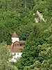
Frauenberg Chapel | Catholic Marienkapelle on the Frauenberg, small rectangular central building with rounded corners and double dome, eastern altar niche and short western vestibule, 1738–1739 by Gabriel de Gabrieli ; with equipment ; the sexton's house attached to the east was built before 1767 as a hermitage. | D-1-76-123-61 |
 more pictures |
| Frauenberg; Ochsenfelder Weg ( location ) |
Way of the Cross in Kastanienallee | 14 Stations of the Cross, wayside shrines formerly with cast iron reliefs, 1856; in Kastanienallee planted from 1875. | D-1-76-123-62 |
_-w0809.jpg) more pictures |
| Friedhofgasse 1 ( location ) |
Residential building | In Jura construction, plaster structure over half-timbering, early 18th century (before 1761), wooden door frame with skylight probably 19th century, the double door leaf 18th century. | D-1-76-123-66 |

|
| Friedhofgasse 4 ( location ) |
Residential building | Originally a free-standing two-storey eaves side house from 1616 (dendrologically dated), coat of arms stone over arched portal, marked with the year 1616, inscription stone from the building period with a quote from Psalm 127. | D-1-76-123-67 |

|
| Friedhofgasse 10 ( location ) |
Stone tablet | With a labeled cartridge, marked with the year 1557. | D-1-76-123-69 |

|
| Gabrielistraße 1 ( location ) |
Community center | Three-storey, eaves with a gently sloping gable, console bay window and plastered facade, mid-19th century, probably older in the core. | D-1-76-123-72 |
 more pictures |
| Gabrielistraße 2; Marktgasse 1 ( location ) |
Community center | Four-storey, end of the 17th century, stucco facade around 1740. | D-1-76-123-73 |
 more pictures |
| Gabrielistraße 4; Marktgasse 3 ( location ) |
Gabriel de Gabrielis house | Built in 1686, three-storey, in the middle with a two-storey bay window and a dwelling, baroque facade design by Gabriel de Gabrieli in 1733. | D-1-76-123-74 |
 more pictures |
| Gabrielistraße 6; Marktgasse 5 ( location ) |
Municipal office and city court | Residential and commercial building with a restaurant, three-storey eaves side building with a dwelling, accessed from two streets, probably by Giovanni Giacomo Engl 1683. | D-1-76-123-461 |
 more pictures |
| Gabrielistrasse 8; Marktgasse 7 ( location ) |
Community center | Three-storey with a central bay, probably end of the 17th century, baroque stucco facade marked with the year 1738. | D-1-76-123-75 |
 more pictures |
| Galgenberg ( location ) |
Executioner's chapel on the high court | On the former Galgenberg, stately gable path chapel with crucifixion group and lime slab cover, marked with the year 1788. | D-1-76-123-156 |
 more pictures |
| Gesellenhausweg 3 ( location ) |
Former garden shed | Substructure consisting of a longitudinal, barrel-vaulted cellar and high storage floor, probably first half of the 18th century, partly reaching into the slope, in 1895 apartment installation on the upper floor (former dance hall) and an extension around a knee with a flat pitched roof (originally a garden house at Kolpingstraße 3, see there). | D-1-76-123-408 |
.jpg) more pictures |
| Glass garden 4; Glass garden 8; Glass garden 12/13; Gottesackergasse ( location ) |
Garden wall | Lateral garden walls of the so-called glass garden and rear wall along Gottesackergasse, 17th century, the latter with a round arched stone portal, marked with the year 1604 (between Gottesackergasse 12 and number 16) | D-1-76-123-170 |
.jpg) more pictures |
| Glass garden 9; Glasgarten 11 ( location ) |
Garden pavilions | Two similar garden pavilions with hipped roofs, around 1782/83 (dendrologically dated), probably by Maurizio Pedetti; Glass garden 9 and 11, formerly part of the nursery property Ostenstraße 17 (see also there). | D-1-76-123-79 |
.jpg) more pictures |
| Near Gottesackergasse ( location ) |
East cemetery | Annex 1535, expanded in 1607 and in the 19th century; Enclosing wall with grave monuments from the 16th to the late 19th century; Catholic cemetery chapel Maria Schnee , formerly called All Saints Chapel , small hall building with open vestibule and roof turret, marked with the year 1535, rebuilt in 1717, changes in 1790; with equipment; Mount of Olives, 16th century; Memorial obelisk, first third of the 19th century; two classical soldier monuments, 1827 and 1832; Funeral hall, neo-Romanesque, 1886; Funerary monuments from the 16th to 20th centuries. | D-1-76-123-78 |
 more pictures |
| Gottesackergasse 12 ( location ) |
Residential building | Small two-storey house with a mansard hipped roof, in the style of the baroque garden pavilion, one-storey drawing studio from 1898, heightened and converted into a house in 1922. | D-1-76-123-390 |
.jpg) more pictures |
| Gottesackergasse 16 ( location ) |
Former garden pavilion | Two-storey above a high basement, with a hipped roof and painted architectural structure, built in 1719 (dendrochronologically dated), the north wall also part of the garden wall; Garden gate framing with two coats of arms; |
D-1-76-123-80 |
 more pictures |
| Gutenberggasse 1 ( location ) |
Residential building | Corner building facing Gutenbergstrasse with a polygonal beveled front and a protruding upper floor and knee floor, in the core 15th / 16th. century | D-1-76-123-53 |
.jpg) more pictures |
| Heidingsfelderweg 88; Zum Tiefen Tal 2 ( location ) |
Former brewery summer cellar | Wide-spread building with portal elevation and slate roof, classicistic, marked with the year 1837 | D-1-76-123-81 |

|
| Hofgarten 1 ( location ) |
Branch library III | Former state and episcopal seminar library, today branch library III of the Catholic University of Eichstätt-Ingolstadt , cube-shaped, high magazine building with flat roof, reinforced concrete construction with exposed concrete panes, divided by vertical window strips, encompassed by single-storey, connected flat roof wings, with enclosure, by Karljosef Schattner , 1963-1965 ; designed green space by Gerhart Teutsch, at the same time | D-1-76-123-687 |
.jpg) more pictures |
| Near Hofmühlstraße ( location ) |
Storage cellar | Two-storey cellar with four rooms and an entrance, according to the inscription occupied in 1787, storage cellar of the Hofmühl brewery until 1924; Step stone, marked with the year 1744, in the terrace wall |
D-1-76-123-154 |
.jpg) more pictures |
| Hofmühlstrasse 10 ( location ) |
Prince-Bishop's court mill and brewery | Multi-wing assembly with several coat of arms stones; Residential building consisting of two wings with a gable roof, essentially parts of the original building erected between 1492 and 1515/1516, restored by Pedetti and probably Matthias Seybold after the fire of 1752, gate passage and bay window marked with the years 1680 and 1860 (renewal); Economy buildings, three-part west wing with a limestone roof, marked with the year 1516 and 1707; East wing, three-storey gable building, with coat of arms stone marked with the year 1639 and coat of arms stone by Christian Handschuher with the year 1686 (modern raised), north connected long wing with gable roof and dormers, marked with the year 1515. | D-1-76-123-84 |
.jpg) more pictures |
| Ingolstädter Straße 3 ( location ) |
Grain box of the Sebastian Brotherhood | Three-story with stepped gables, inscribed with a coat of arms on the inscription board with the year 1521 (dendrologically dated 1520/21) (see also Sebastiangasse 7) | D-1-76-123-86 |
 more pictures |
| Ingolstädter Straße 8 ( location ) |
Residential building | Jura house, two-storey, gable-independent flat gable roof building, 1688 (documented), 1687 (dendrologically dated) repair of the core building from the 16th century, probably second shifted late Gothic door frames, renovations in the 19th and 20th centuries. | D-1-76-123-87 |

|
| Ingolstädter Straße 32 ( location ) |
Cobenzlschlösschen | Transversely oval central section raised by an attic with short biaxial transverse wings, built by Gabriel de Gabrieli in 1730/40 , seven-axis eastern extension, 1904, 1863–1964 gas works; to the south remains of the garden's terraces; |
D-1-76-123-88 |
.jpg) more pictures |
| Near Ingolstädter Straße 36 ( location ) |
Memorial stone | Memorial stone for the founder of the Cobenzlpark, Ludwig von Cobenzl , erected by his friend Wilhelm von Hompesch , numbered 1789, 1793. | D-1-76-123-698 |
 more pictures |
| Ingolstädter Straße 36 ( location ) |
Siechhof | Former Siechhof St. Lazarus, group of buildings connected to one another by enclosing walls consisting of a gable-independent parsonage (so-called beneficiary house), in Jura construction, 17th / 18th centuries. Century, Gothic in the basement; former infirmary, later converted into a barn, elongated ground floor building with half-timbered knee-length, dendrochronologically dated 1417; Siechenkapelle St. Lazarus and St. Magdalena, hall building with tail gables and retracted rectangular choir, 17th century, Gothic in the basement (donated in 1346) | D-1-76-123-89 |
 more pictures |
| Kapellbuck; Kapellbuck 3 ( location ) |
Courtyard gate and retaining wall | Hoftor (Kapellbuck 3), marked with the year 1568, and retaining wall at Kapellbuck, 17./18. century | D-1-76-123-90 |
.jpg) more pictures |
| Kapellbuck 4 ( location ) |
Residential building | Two-storey, with an extended half-timbered knee and lime slab roof, dendrologically dated 1723/24 | D-1-76-123-365 |
.jpg) more pictures |
| Kapellbuck 7 ( location ) |
Residential building | In Jura construction, two-storey middle-floor house with knee-high floor and lime slab roof as well as front staircase, renewed around 1700 to 1716 (dendrologically dated), on an older foundation. | D-1-76-123-91 |
 more pictures |
| Kapuzinergasse 2 ( location ) |
Capuchin Church, monastery building and monastery wall | Catholic Capuchin Church of the Holy Cross and the Holy Sepulcher, built 1623–1625, large hall building in the style of mendicant churches, emphasized simply kept hall building with drawn-in, just closed choir, the choir was increased by a library floor in 1905, to the south of the nave the almost equally high chapel for the Holy Sepulcher; with equipment ; Holy grave of the time around 1160, removed when the Schottenkapelle was torn down in 1610 and rebuilt in 1623 at the current location, now facing north-south; only the east wing of the 17th century monastery has been preserved, the others demolished in 1986 and replaced by the Munich architect Christian Kronenbitter by a new building adapted to the cubature of the old monastery by 1988; Well in the courtyard marked with the year 1621; Monastery garden with walling, 17th century; in the northern section of the garden wall figurine niche with a larger than life, colored statue of the Madonna, probably a model for the figure of Mary on the fountain column on Residenzplatz, by Johann Jakob Berg, around 1778/80. | D-1-76-123-93 |
 more pictures |
| Kapuzinergasse 5 ( location ) |
So-called Hirschbeck House | Residential house with high dormer windows and stepped gable facing the garden, in the core early 18th century, raised and reshaped in 1897. | D-1-76-123-375 |
 more pictures |
| Kapuzinergasse 1; Kapuzinergasse 3 ( location ) |
Garden wall with gate | Associated garden wall with gate, 16./17. Century, arched gate marked with the year 1560. | D-1-76-123-92 |
.jpg) more pictures |
| Kardinal-Preysing-Platz 1 ( location ) |
Hofstall | Part of a four-wing complex, early 18th century, neo-baroque extension with gable, plaster structure and portal in 1904; see also Ostenstrasse 1. | D-1-76-123-2 |

|
| Kardinal-Preysing-Platz 3 ( location ) |
Hofstall | Elongated gable structure, with plaster structures, first half of the 18th century; to the south, gate entrance and garden wall, probably mid-19th century. | D-1-76-123-3 |

|
| Kardinal-Preysing-Platz 6 ( location ) |
Farriers and gunsmiths | Corner house with flat saddle roof, core 1688/89 (dendrologically dated), portal marked with the year 1858, canopy on cast iron supports and iron fence, end of the 19th century; in the workshop fireplace, anvil, cast iron well, marked with the year 1875; on the north side of the house wall fountain, neo-renaissance, and several cast plates, probably from Obereichstätt, 18th and 19th centuries, to the rear of the Gottesackergasse courtyard gate from 1881. | D-1-76-123-5 |

|
| Kolpingstrasse 1 ( location ) |
Prince-Bishop's caretaker | From 1884 house of the Catholic journeyman's association, today Kolping House, stately Jura residential building with a street passage and a former business section at the back, probably rebuilt by Giovanni Giacomo Engl in 1692 after destruction in the Thirty Years War , marked in the coat of arms with the year 1692. | D-1-76-123-94 |
.jpg) more pictures |
| Kolpingstrasse 3 ( location ) |
So-called Hofer house | Former home of the Prince Bishop's personal physician Dr. Andreas von Starkmann, three-storey with a gently sloping lime slab roof, oval window in the knee floor, around 1730, renovation of the roof between 1789 and 1802; with garden enclosure (formerly associated garden pavilion see Gesellenhausweg 3 ). |
D-1-76-123-95 |
 more pictures |
| Kolpingstrasse 9 ( location ) |
Residential building | At the gable end with half-timbered knee-high and exposed cellar on the valley side, after fire 1794–1797 (dendrologically dated 1794/95) on an older core, stone door walls marked with the year 1612, probably from the previous building, relief panel, deposition of the cross. | D-1-76-123-376 |

|
| Leonrodplatz ( location ) |
Wittelsbacher fountain | Neo-Baroque fountain basin with aedicule by Carl Sattler , aedicule figure of the patrona Bavariae by Irene Hildebrand , inscribed with the year 1906. | D-1-76-123-100 |
 more pictures |
| Leonrodplatz 1; Leonrodplatz 3; Seminar path 3; Wiesengäßchen ( location ) |
Jesuit college with guardian angel church | Catholic Guardian Angel Church (Jesuit Church), wall pillar construction with retracted choir, facade with curved gable, tower set back to the south, probably built by Hans Alberthal 1617–1620 , rebuilt after fire 1634–1661 (re-vaulting) by Frater Oswald Kaiser, redesign inside 1717 with Rococo stucco by Franz de Gabrieli and frescoes by Johann Michael Rosner, renovation 1961–1964; with equipment ;
former Jesuit college, now episcopal seminary, complex of the 17th century, extensions with two inner courtyards in 1772 and 1930, new construction and renovation 1981–1984 by Karljosef Schattner ; with equipment; Parts of the city wall, late medieval. |
D-1-76-123-96 |
 more pictures |
| Leonrodplatz 2 ( location ) |
Hof Welden | Evangelical-Lutheran parsonage since 1886, baroque building with pilasters and mansard roof, probably by Gabriel de Gabrieli around 1720, with a connection to the parish church on the reverse (see Residenzplatz 19) and an integrated round stair tower, end of the 16th century; historicist enclosure with stone posts and cast iron fence and gate grille from the last quarter of the 19th century. | D-1-76-123-97 |
 more pictures |
| Leonrodplatz 4 ( location ) |
Former cathedral deanery | Now Episcopal Ordinariate, free-standing three-storey building with tail gable and corner core, probably built by Maurizio Pedetti, built in 1765, completely gutted inside by Karljosef Schattner in 1965/66 and the ailing outer walls partially laid down, rebuilt and changed with a new, 1.5-storey portal. | D-1-76-123-98 |
 more pictures |
| Leonrodplatz 5 ( location ) |
Former Jesuit grammar school (Konvikt) | Adjacent to the former Jesuit college, a simple three-and-a-half-story plastered building, marked with the year 1626. | D-1-76-123-99 |

|
| Leuchtenbergstrasse 1 ( location ) |
Former Großscher Domherrenhof | Residential building on Domplatz with passage to Leuchtenbergstrasse, 16./17. Century, wing building on Leuchtbergstrasse with mansard hipped roof, built by Gabriel de Gabrieli in 1737. | D-1-76-123-101 |
 more pictures |
| Leuchtenbergstrasse 2 ( location ) |
Residential and commercial building | Two-story, baroque hipped roof building, 18th century. | D-1-76-123-102 |
 more pictures |
| Leuchtenbergstrasse 3 ( location ) |
Residential building | Two-wing building, with a baroque portal and plaster structures, probably 18th century. | D-1-76-123-103 |

|
| Luitpoldstrasse 1 ( location ) |
Former Ostein-Riedheim-Hof | Rococo palace with a mansard hipped roof, central projectile and stuccoed facades, built by Gabriel de Gabrieli , around 1730; Conversion 1992–1994 to the diocesan archive by Karljosef Schattner . | D-1-76-123-104 |
 more pictures |
| Luitpoldstrasse 2 ( location ) |
Former cathedral provost house | Now the Episcopal Ordinariate, baroque two-wing corner building with a polygonal corner bay, built by Giovanni Giacomo Engl in 1672, renovation and plastered facade with pilasters in 1770; backwards, baroque garden; Garden pavilion around 1700, attached to a city wall tower (see also city fortifications); Enclosed by a piece of city wall (see city fortifications) and a garden wall facing Ostenstrasse around 1700. | D-1-76-123-105 |
.jpg) more pictures |
| Luitpoldstrasse 4 ( location ) |
Former cathedral chapter house | Three-storey eaves side building with knee stick in Jura construction, building inscription marked with the year 1553, remodeling in 1776, two relief busts, Emperor Karl V and Duke Wilhelm IV, inserted in the gable facade on Wohlmuthgasse, by Loy Hering around 1553. | D-1-76-123-106 |
 more pictures |
| Luitpoldstrasse 5 ( location ) |
Former canon court of Thurn-Valsassina | Four-story, first half of the 18th century, probably by Benedikt Ettl . | D-1-76-123-107 |
.jpg) more pictures |
| Luitpoldstrasse 8 ( location ) |
Former canon court Schönau-Schrattenbach | Simple eaves residential building, three-storey with knee-high floor; Wing structures arranged backwards around an inner courtyard, 16th century, rebuilt in 1741, hall with stucco in the garden wing; Parts of the city wall and fortification tower, late medieval, adjoining the garden (see sub-data set city fortifications). | D-1-76-123-108 |

|
| Luitpoldstraße 9 ( location ) |
Community center | Gable-independent in Jura construction, three storeys, marked with the year 1702. | D-1-76-123-109 |

|
| Luitpoldstrasse 10 ( location ) |
Former Andlau canon court | Classicist eaves side building, 1830/40; original main building in the courtyard, gable building, marked with the year 1525, on a medieval core, remodeled 18th century; Outbuilding, probably 18th century; Parts of the medieval city wall with defense tower, adjacent to the garden (see city fortifications). | D-1-76-123-110 |

|
| Luitpoldstrasse 11 ( location ) |
Community center | At the top of the gable, three-story, early 18th century, rich neo-baroque stucco facade, late 19th century. | D-1-76-123-111 |
 more pictures |
| Luitpoldstrasse 14 ( location ) |
Community center | Three-storey wide gable building, marked with the year 1718. | D-1-76-123-112 |
 more pictures |
| Luitpoldstrasse 15 ( location ) |
Community center | Mansard gable building free-standing on three sides, with plastered structure, second half of the 18th century. | D-1-76-123-113 |

|
| Luitpoldstrasse 16 ( location ) |
Bürgerhaus (birthplace of Max von Widnmann ) | Three-storey with knee-high floor and horizontal band division, grown together from components from different periods, the core building erected before the middle of the 15th century over the cellar of a Romanesque residential tower, walled-in late Gothic relief stone Maria and John, inscribed on the walled-in cathedral chapter coat of arms with the year 1613, roof framework around 1700. | D-1-76-123-114 |
 more pictures |
| Luitpoldstraße 18 ( location ) |
Community center | On the eaves side, with gable and plaster structures, marked with the year 1748. | D-1-76-123-115 |
 more pictures |
| Luitpoldstraße 19 ( location ) |
Community center | Broad gable-independent Jura house, two-storey with knee-length floor, two corner cores and plaster structures, built by Benedikt Ettl in 1727. | D-1-76-123-116 |
 more pictures |
| Luitpoldstrasse 20 ( location ) |
Residential building | Corner building with risalit bay and triangular gable, built by Matthias Seybold over the older core, coat of arms stone marked with the year 1744. | D-1-76-123-117 |
 more pictures |
| Luitpoldstraße 22 ( location ) |
Community center | Narrow corner building, marked in the door arch with the year 1587, with a high, round mansard gable from the 18th century, heavily overformed. | D-1-76-123-118 |
 more pictures |
| Luitpoldstraße 23 ( location ) |
basement, cellar | Arched with a longitudinal barrel made of limestone, medieval. | D-1-76-123-377 | |
| Luitpoldstraße 26 ( location ) |
Residential building | Gabled semi-detached house with two entrances, plastered half-timbering, marked with the year 1576, on the cellar area 13./14. Century. | D-1-76-123-119 |
 more pictures |
| Luitpoldstraße 29 ( location ) |
Community center | Three-storey saddle roof building, corner building with a polygonal corner bay, built around 1695 by Giovanni Giacomo Engl . | D-1-76-123-121 |
 more pictures |
| Luitpoldstraße 34 ( location ) |
Community center | Eaves side, with protruding half-timbered upper storeys, crane hatch and arched gate entrance, probably 16th century. | D-1-76-123-123 |

|
| Luitpoldstrasse 35 ( location ) |
Statue of St. Willibald | Probably 17th century, perhaps by Christian Handschuher, on the front of the house. | D-1-76-123-124 |

|
| Luitpoldstraße 36 ( location ) |
Prince-Bishop's Oberstjägermeisterei | Eaves baroque palace with stucco facade and flat hipped roof as well as wide central projection with elaborate portal (marked with the year 1722), Ionic pilasters and triangular gable, by Gabriel de Gabrieli 1722; Rear building along Dominikanergasse, ground floor with Renaissance walls, 16th century, first floor probably baroque, in 1892 the second floor was added. | D-1-76-123-125 |
 more pictures |
| Luitpoldstrasse 38; Luitpoldstrasse 40 ( location ) |
Former Dominican monastery | Secularized 1806, from 1834 teacher training institute, from 1950 grammar school, since 1965 called Gabrieli grammar school , three-wing complex connected to the north of the church, arranged around a courtyard, 1649 and 1661, in the course of new construction and repair measures 1903-06 of the north wing (1903/04 ) built, east wing renewed after fire (1918) 1919–1921; Former Dominican Church of St. Peter and Paul (Dominikanergasse 1), early Gothic, around 1278, redesign and baroque facade in 1713 and subsequent years by Benedikt Ettl, restored after destruction by fire (1918) 1919–1924, further changes 1977–1979. |
D-1-76-123-127 |
 more pictures |
| Marktgasse 2 ( location ) |
Community center | Right on the gable, four-storey, with a structured plastered facade and high gabled portal, first half of the 18th century. | D-1-76-123-128 |
 more pictures |
| Marktgasse 8 ( location ) |
Community center | Four-storey, with plastered structure, inset spoilage and portal, marked with the year 1743, to Widmanngasse. | D-1-76-123-131 |

|
| Marktgasse 9 ( location ) |
Residential building | Three-story, three-sided free-standing corner building facing Luitpoldstrasse with two corner cores, built by Giovanni Giacomo Engl 1680–1685, elaborate stucco facade around 1740, opulent front door with skylight around 1900. | D-1-76-123-132 |
 more pictures |
| Marktgasse 10; Marktgasse 12 ( location ) |
Community center | Gable and eaves-side part connected by a uniform plaster structure, probably early 18th century, plaster structure from 1900. | D-1-76-123-133 |
 more pictures |
| Marktgasse 14; Marktgasse 16; Winkelwirtsgasse 1 ( location ) |
Basement | Cellar of a former brewery, under the buildings Marktgasse 14, 16 and Winkelwirtsgasse 1, branched, multi-storey complex with connecting stairs, low-set barrel vault made of stone, medieval. | D-1-76-123-696 | |
| Marktgasse 20 ( location ) |
Residential and commercial building | Corner building, three-storey with a mansard hipped roof, corner bay window on lion consoles, mid-17th century, rich plaster structure and mural around 1900. | D-1-76-123-135 |
.jpg) more pictures |
| Marketplace ( location ) |
Willibaldsbrunnen | Quadruple-shaped basin, 1695 by Giovanni Giacomo Engl , bronze figure of St. Willibald by Hans Krumpper on the fountain pillar . | D-1-76-123-153 |
 more pictures |
| Marketplace 1 ( location ) |
Former canon court | Three-storey corner building with a two-storey flat bay window and Renaissance portal on Gutenberggasse, marked with the year 1581, stone Neidkopf at the corner, plastered facade with mural, Maria Immaculata, on the eaves side 18th century, renovations in 1912 and second half of the 20th century. | D-1-76-123-136 |
 more pictures |
| Marketplace 2 ( location ) |
Residential and commercial building | Elongated three-storey building wing with knee-high floor and two polygonal corner cores, marked with the year 1894. | D-1-76-123-137 |
 more pictures |
| Marketplace 3 ( location ) |
Former canon house | Baroque building on the eaves, 18th century, from this time the high portal crowning, the core building from a conversion dated 1541. | D-1-76-123-138 |
 more pictures |
| Marketplace 5 ( location ) |
Former canon court in Pappenheim | Corner building with polygonal corner bay window and arched portal to Loy-Hering-Gasse, oldest parts perhaps around 1484, many changes, coat of arms stones above the entrance portal marked with the years 1699, 1725 (Chronistchon) and 1902. | D-1-76-123-139 |
 more pictures |
| Marktplatz 6 ( location ) |
Community center | Classicist building on the eaves, three-storey, portal on the gable side, end of the 18th century; perhaps on an older core, wrought iron balcony grating on the first floor marked with the year 1895, at the same time the roof parapet, ground floor, second half of the 20th century gutted. | D-1-76-123-140 |
 more pictures |
| Marketplace 7 ( location ) |
Remains of the former collegiate and parish church of Our Lady | Preserved in a new bank building, late Gothic, built 1472–1546 by Magnus Dreer and Erhard Reich, demolished in 1818, built over by a four-wing complex built after 1818. | D-1-76-123-141 |
 more pictures |
| Marktplatz 9 ( location ) |
Community center | Free-standing on three sides, two-storey with a tail gable, dendrologically dated in the core 1313, with an 18th century facade, the massive ground floor totally changed in 1970. | D-1-76-123-142 |
 more pictures |
| Marketplace 10 ( location ) |
Community center | Three-storey with a tail gable facing the market square, 18th century. | D-1-76-123-143 |
 more pictures |
| Marktplatz 11 ( location ) |
town hall | Free-standing gable building with a side tower attached to the pile road, 1444, facade with pilaster strips and tail gable as well as the tower crowning 1823–1824. | D-1-76-123-144 |
 more pictures |
| Marktplatz 12 ( location ) |
Community center | Corner building, 16./17. Century, faded pilaster structure and plaster facades with tail gables, 18th / 19th century. Century. | D-1-76-123-145 |
 more pictures |
| Marktplatz 13 ( location ) |
Community center | Gable-independent building, marked on the southeast side with the year 1665 and 1805, facade structure around 1900. | D-1-76-123-146 |
 more pictures |
| Marktplatz 14 ( location ) |
Former town house | Four-storey, free-standing, with hipped roof and two corner cores, 1696 based on plans by Jakob Engel , plastered facade 19th century. | D-1-76-123-147 |
 more pictures |
| Marktplatz 15 ( location ) |
Marienapotheke | Corner building with classical gable front, 1797, on an older basis. | D-1-76-123-148 |
 more pictures |
| Marktplatz 16 ( location ) |
Former normal school | Simple three-storey gable-independent building with a gently sloping gable roof, 18th / 19th centuries Century, normal school from 1787 to 1804, in the core probably 17th century. | D-1-76-123-149 |
 more pictures |
| Marktplatz 18 ( location ) |
Hotel grape | Gable building with cantilevered upper floors, flat bay windows on the east side, early 17th century (marked with the year 1615), expansion in the 18th century, upper floor and stepped gable in 1929. | D-1-76-123-150 |
 more pictures |
| Marktplatz 22 ( location ) |
Hotel Adler | Eaves side building, second floor cantilevered, 17./18. Century; perhaps on the older core, plastered facade and wide window installation on the ground floor at the end of the 19th century; structurally connected to house no.24. | D-1-76-123-151 |
 more pictures |
| Marktplatz 24 ( location ) |
Hotel Adler | Corner house with high tail gable, 17th / 18th centuries Century, perhaps on an older core, plaster facade at the end of the 19th century; structurally connected to house No. 22. | D-1-76-123-152 |
 more pictures |
| New way 1 ( location ) |
Former executioner's house | Town peasant estate, former executioner's house; three buildings lined up along the street; the slightly recessed, gable-facing two-storey residential building in Jura construction with a limestone roof and a loading hatch with elevator boom, 18th century, perhaps on an older core; to the north, a two-storey stable building in the Jura construction, probably 18th century; to the south adjoining the eaves barn with a muddy half-timbered upper part, with a limestone roof, probably 18th century. | D-1-76-123-155 |

|
| Notre Dame 1; Kardinal-Preysing-Platz 14; Gottesackergasse 1; Kardinal-Preysing-Platz 8/10/12 ( location ) |
Former Augustinian women's choir and monastery church | Former Augustinian women's choir and monastery church de Notre Dame du Sacre Coeur, today Altmühltal Nature Park Information Center, central building with a convex facade and dome, flanked by two three-storey side wings each with three window axes with pilasters, built by Gabriel de Gabrieli from 1719, inside frescoes by Johann Georg Bergmüller , secularized in 1809; structurally connected to the former convent building (Kardinal-Preysing-Platz 14), baroque hipped roof building, three-storey, arched portal with explosive gable, marked on the coat of arms stone in the gable field with the year 1713, above niche with Nepomuk figure from 1760; then further monastery buildings: Gottesackergasse 1, rear four-story pavilion extension, built in 1714 ff., fundamentally rebuilt in 1964 and 1971; Kardinal-Preysing-Platz 8/10/12, classrooms until 1719, then girls' boarding school, four-storey baroque mansard roof building, 1714–1716 by Gabriel de Gabrieli; see also: Am Graben 26 (former schoolhouse of the external), Antonistraße 4,6,8 and Notre-Dame-Weg 5. | D-1-76-123-9 |
 more pictures |
| Notre-Dame-Weg 5 ( location ) |
pavilion | Two-storey hipped roof building, belonging to the former Notre Dame monastery, around 1721, rebuilt in 1984 , probably according to plans by Giovanni Domenico Barbieri or Gabriel de Gabrieli (see also Notre Dame 1). | D-1-76-123-157 |

|
| Ostenstrasse 1 ( location ) |
Auditorium | Part of the former court stable, at the beginning of the 18th century, converted into an auditorium in 1868/69 and 1903/04, with a neo-baroque plaster structure (see also Kardinal-Preysing-Platz 1, 3). | D-1-76-123-158 |
 more pictures |
| Ostenstrasse 2 ( location ) |
Residential building | Small two-storey saddle roof building, eaves, part integrated into the Ostentor as a flank building until 1876, in the core probably 15th century, renewed around 1718 towards the middle of the 19th century, reconstruction in 1993 | D-1-76-123-159 |

|
| Ostenstrasse 4 ( location ) |
Former bakery | Two-storey massive eaves side building, in Jura construction, originally with lime slab roof, early 18th century, rear extension with lime slab roof in the southeast and arbor with oriel protrusion on the eaves side to the garden from 1888, ground floor gutted during renovation in 1964. | D-1-76-123-161 |

|
| Ostenstrasse 5 ( location ) |
portal | Profiled stone portal wall with two-winged, richly carved front door, around 1769. | D-1-76-123-162 |

|
| Ostenstrasse 7 ( location ) |
Bakery and residential building | At the top of the gable, two-storey with a high knee and a flat pitched roof, round window in the gable, 1691 (documented), roof structure 1689/90 (dendrologically dated), plaster structure changed in 1925, interior renovations in the 1950s and 1960s, ground floor gutted. | D-1-76-123-164 |

|
| Ostenstrasse 11 ( location ) |
Community center | Two-storey corner building with a steep gable, 1708 (dendrologically dated), remodeling in 1933 and 1968. | D-1-76-123-165 |

|
| Ostenstrasse 13 ( location ) |
Residential and commercial building | Three-storey, independent from the gable, with rich plastering, ground floor and first floor probably 17th century, renovation with addition of the second floor and roof structure started in 1767/68 (dendrologically dated) by Maurizio Pedetti (in structural connection with No. 15, see there), Modifications in 1897 and 1938. | D-1-76-123-166 |

|
| Ostenstrasse 14 ( location ) |
Residential building | Stately gable-independent central corridor house with a steep gable roof and richly crafted double-winged front door with skylight, 1706 (dendrologically dated), older in core. | D-1-76-123-167 |

|
| Ostenstrasse 15 ( location ) |
Monopitch roof construction | Connected to No. 13 (see there), with a blind balustrade in front of the lime-slab pent roof, rich plaster structure, 1768, originally the outbuilding from No. 13, separated in 1895. | D-1-76-123-168 |

|
| Ostenstrasse 17 ( location ) |
Plant nursery estate | Former “late gardening” for the prince-bishop; Gable-independent house with a steep pitched roof, built in 1707 (dendrologically dated), renovations from 1961 to 1966 and 1972/73; originally associated wall sections from the 16th century to the neighboring property on the side and two late baroque garden pavilions (see glass garden no. 9 and no. 11) on the northern property wall to Gottesackergasse; Comprehensively renovated in 2016/2017. | D-1-76-123-392 |
.jpg) more pictures |
| Ostenstrasse 22 ( location ) |
Former cavalier house | Formerly a three-wing mansard hipped roof, today reduced to the wing facing the street, probably by Gabriel de Gabrieli , 1737/38, connected to the prince-bishop's summer residence (Ostenstraße 26) through a courtyard entrance with rusticated pillars and formerly connected to the orangery building (Ostenstraße 24) through the wings . | D-1-76-123-169 |
 more pictures |
| Ostenstrasse 25 ( location ) |
Former orphanage | Two three-storey gable-independent houses from the 16th century, combined by Giovanni Domenico Barbieri according to plans by Maurizio Pedetti in 1758 to form a four-wing complex with a high three-storey gable facing the street and a pent roof facing the inner courtyard, marked with the years 1695 and 1715, in the course of the conversion to the Institute for Psychology Catholic University 1985–1988 by Karljosef Schattner added a new staircase to the rear. | D-1-76-123-172 |
 more pictures |
| Ostenstrasse 26 ( location ) |
Former prince-bishop's summer residence with courtyard garden | Former summer residence of the Prince-Bishop, university since 1977, elongated Baroque complex, symmetrical with a central raised corps de logis and narrow gallery wings that end in corner pavilions, built by Gabriel de Gabrieli 1735–1737 ; to the south adjoining courtyard garden with three garden pavilions by Gabriel de Gabrieli connected by fencing walls, central pavilion 1736, redesigned into a belvedere with fountain by Maurizio Pedetti, 1779–1781, garden figures, 18th century, two of which were signed by Johann Jakob Berg in 1765; Orangery (Ostenstraße 24) around 1740. | D-1-76-123-171 |
 more pictures |
| Ostenstrasse 27 ( location ) |
Hofbeamtenhaus | Three-storey hipped roof building, formerly with dormers and a dwarf house, dendrologically dated 1719/20, entrance door around 1790. | D-1-76-123-173 |
 more pictures |
| Ostenstrasse 28; Ostenstrasse 28a ( location ) |
College building | Group of cuboid structures in reinforced concrete skeleton with infill made of quarry stone masonry in Jura limestone, arranged around the central courtyard area, partly connected with corridors, planned around 1960 by Karljosef Schattner , Eichstätt, and Josef Elfinger, Ingolstadt: seminar building / lecture hall building (1962), house of the administrator or Caretaker (1962–1965), art building (1965, supplemented 1979/80), sports building (1963), music building (1967), auditorium (1967); Open space with fountain courtyard and open-air stage, by Gerhart Teutsch, 1960–1965.
(For the associated cafeteria, see Universitätsallee 2 ) |
D-1-76-123-684 |
.jpg) more pictures |
| Ostenstrasse 29 ( location ) |
Late medieval assembly | Small late medieval assembly in half-timbered stand construction with baroque renovation of the street-side facades in plastered masonry; gable-independent main building, two-storey with knee-length floor and lime slab roof, built around 1442/43 and extended on the eastern long side around 1562, changes in 1699, 1756–1766 and 1887 (data dendrologically dated), extensively rebuilt in 2000; To the east, a narrow eaves extension, two-storey with a knee-high floor and a steep gable roof, around 1572 (dendrologically dated). | D-1-76-123-393 |
 more pictures |
| Ostenstrasse 31a ( location ) |
Former Spethsch canon court | Three-storey hipped roof building with corner bay window, built in 1690 by Giovanni Giacomo Engl , furnished and expanded as a seminary in 1710, side wing with chapel in 1763, as a workhouse in 1783, as a hospital in 1841; with equipment. | D-1-76-123-174 |
 more pictures |
| Parking garage street; Back facet ( location ) |
Cross stone | Medieval; am Frauenberg, about 600 m southeast of the Frauenberg chapel in an open field in the direction of the airfield west of the road to the parking garage. | D-1-76-123-65 |
 more pictures |
| Parking garage street; Posterior facet; ( Location ) |
Wayside shrine with Vesper picture | Under the northern avenue trees on Parkhausstraße between Vogelherdweg and the multi-storey car park, two sides with inscriptions and two relief sides, inscribed with the year 1689. | D-1-76-123-63 |
 more pictures |
| Parkhausstraße 28 ( location ) |
Deer parking garage | So-called “deer park house”, late Classicist-Biedermeier hipped roof building, built as a Herzoglich-Leuchtenberg forest house around 1820/30, used as a state forester's residence after 1854; with agricultural outbuildings. | D-1-76-123-404 |
.jpg) more pictures |
| Pater-Philipp-Jeningen-Platz 1 ( location ) |
Residential building | Gable-sided, two-storey flat gable roof building with knee floor, half-timbered upper storey, 1467/68 (dendrologically dated). | D-1-76-123-586 |
.jpg) more pictures |
| Pater-Philipp-Jeningen-Platz 2 ( location ) |
Former cathedral school | Three-storey building, 15th century, baroque style, with late Gothic portal to the cloister and arched portal from the 17th century (see also Domplatz 12). | D-1-76-123-175 |
 more pictures |
| Pater-Philipp-Jeningen-Platz 3 ( location ) |
Episcopal palace | Former canon court Schönborn, two- to three-storey baroque four-wing complex with rusticated ground floor and corner bay window facing Leonrodplatz, built after 1736 by Gabriel de Gabrieli with the inclusion of older parts, rebuilt in 1970/71 by Karljosef Schattner . | D-1-76-123-176 |
 more pictures |
| Pater-Philipp-Jeningen-Platz 4 ( location ) |
Cathedral Parish Office | Former cathedral chapter drinking room, now cathedral parish office, free-standing three-storey baroque building on three sides based on the previous buildings from 1649 and 1510, with tail gables, risalit, bay window and stucco facades, built by Giovanni Domenico Barbieri in 1749/50 . | D-1-76-123-177 |
 more pictures |
| Pater-Philipp-Jeningen-Platz 6 ( location ) |
Ulm court | Former canon court in Ulm, now part of the Eichstätt University, three-storey four-wing complex with corner oriel tower, built around 1625, design to a baroque palace by Giovanni Giacomo Engl in 1688, courtyard entrance marked with the year 1578, conversion 1978–1980 by Karljosef Schattner to the department library theology of the catholic University. | D-1-76-123-178 |
 more pictures |
| Pedettistraße 13a; Westenstrasse 10 ( location ) |
Community center | Assembly group surrounding an inner courtyard with side and rear buildings; eaves-standing, three-storey steep saddle roof structure, the 2nd floor as a half-timbered warehouse, 1411 (dendrologically dated), roof structure 1587 (dendrologically dated) reinforced; Side wing, two-story monopitch roof, 1553 (dendrologically dated), renovated in the 18th century; Rear building facing Pedettistraße, three-storey monopitch roof building with upper half-timbered floor, protruding towards the inner courtyard, on the 2nd floor Bohlenstube, 1457 (dendrologically dated), on an older core; over an extensive, deep cellar that crosses Pedettistraße, 14th century. | D-1-76-123-695 |
.jpg) more pictures |
| Pedettistraße 14 ( location ) |
archway | Archway with grapes in relief, marked with the year 1786. | D-1-76-123-179 |

|
| Pedettistraße 15; Westenstrasse 12 ( location ) |
Residential and commercial building | Assembly on an angular floor plan of originally three individual buildings in closed development, two buildings facing Pedettistraße gable side frame an eaves side building, pent roof facing Westenstraße or hunched over four-story late classicist facades around 1860, the core of the buildings probably 18th century, ground floor gutted. | D-1-76-123-271 |

|
| Pedettistraße 16 ( location ) |
Residential building | Three-storey corner building, 18th century, on an older core. | D-1-76-123-180 |
.jpg) more pictures |
| Pedettistraße 18 ( location ) |
Former smithy and community center | Three-storey corner building with cantilevered upper storeys, probably the 16th century core, wrought-iron balcony around 1900; Comprehensively renovated in 2017–2019. | D-1-76-123-181 |
.jpg) more pictures |
| Pedettistraße 24 ( location ) |
Community center | Two-storey side eaves building with high knee and flat saddle roof, late medieval core, later modified. | D-1-76-123-464 |
.jpg) more pictures |
| Pedettistraße 38 ( location ) |
Residential building | Eaves-sided, two-storey flat gable roof building with a high knee floor and extensive vaulted cellars, 17th / 18th centuries Century, marked on the house stone portal 1773 (dendrologically dated); Comprehensively renovated in 2016/2017. | D-1-76-123-182 |
.jpg) more pictures |
| Petersleite 9 ( location ) |
Former Sölden property | Gable-independent residential house with half-timbered knee-height, 1718/19 (dendrologically dated), attached to the eaves side barn from the 19th century with walled courtyard with stables, on the residential building limestone relief with coat of arms, marked with the year 1760, above that Madonna figure from the 18th / 19th century. Century. | D-1-76-123-184 |
.jpg) more pictures |
| Pfahlstrasse 1 ( location ) |
Former prince-bishop's cavalier house | Three-storey baroque corner building with two-storey polygonal corner bay window , stucco facade and high tail gable, in the core 17th century, Baroque redesign by Giovanni Domenico Barbieri or Matthias Seybold, first half of the 18th century, in a window field in 1913 with a relief representation of the hospital gate from 1673 after a drawing by Johann Maurer. | D-1-76-123-185 |
 more pictures |
| Pfahlstrasse 4 ( location ) |
Community center | Across the gable, three-storey, with two-storey bay window, 17th / 18th century Century. | D-1-76-123-188 |

|
| Pfahlstrasse 5 ( location ) |
Community center | Three-storey gable building with a mansard roof and tail gable, in the core 16./17. Century, rich stucco facade around 1730, probably by Giovanni Domenico Barbieri . | D-1-76-123-189 |
 more pictures |
| Pfahlstrasse 6 ( location ) |
Community center | Two-storey with a steep gable roof and flat console bay window, 17th century. | D-1-76-123-190 |

|
| Pfahlstrasse 7 ( location ) |
Community center | Three-story, with a steep gable, 18th century, probably on an older core, renovations at the beginning of the 19th century. | D-1-76-123-191 |
.jpg) more pictures |
| Pfahlstrasse 9 ( location ) |
Gable-independent plaster construction | Three-storey with a gently sloping gable roof, 17th century (plank ceiling, staircase, roof structure) and 18th century (facades partially renewed), arched portal and two door leaves, early 19th century; Outbuilding to the Altmühlufer. | D-1-76-123-192 |
.jpg) more pictures |
| Pfahlstrasse 16 ( location ) |
Community center | Three-storey corner building with a gently sloping hipped roof, built around 1820–1840 while retaining the outer walls of the former west vestibule of the medieval parish church, on the ground floor a vaulted room with 2 × 4 bays above pillars with belt arch separation, a door wall walled up on the garden side as a spolie, in the arched chronogram marked with the year 1758. | D-1-76-123-193 |

|
| Pfahlstrasse 18 ( location ) |
Community center | Stately corner building, four low storeys, the upper storeys protruding, limestone roof, 15th / 16th c. Century, probably on an older core. | D-1-76-123-194 |
 more pictures |
| Pfahlstrasse 23 ( location ) |
Residential building | Until 1789 so-called Eich-Bad, stately saddle roof construction, probably in the 17th / 18th. Century renewed using older building fabric; with included part of the city wall from the 13th century on the gable side of the Altmühl. | D-1-76-123-378 |

|
| Pfahlstrasse 25 ( location ) |
So-called Heimbäckenhaus | Corner building with mansard roof and rococo plaster facade, marked with the year 1727, by Gabriel de Gabrieli . | D-1-76-123-196 |

|
| Pfahlstrasse 27 ( location ) |
Bummerlbräu | Former Bummerlbräu brewery, a gable-independent building protruding from the street, with a flat pitched gable roof, three-storey with knee-length floor, upper floors overhanging, essentially early 14th century (dendrologically dated 1322–1327), in 1727 the second floor and knee-height floor were added, converted in 1919/96 . | D-1-76-123-197 |
 more pictures |
| Pfahlstrasse 29 ( location ) |
Weißes Rößl | Former inn Weißes Rößl, three-storey side eaves building with richly structured plastered facade, neo-renaissance, around 1870, protruding wing older, ground floor completely gutted during modern renovation. | D-1-76-123-198 |

|
| Pfahlstrasse 35 ( location ) |
Herzogbräu | Gasthof Herzogbräu, gable building, 18./19. Century, with neo-renaissance facade, around 1900. | D-1-76-123-199 |
.jpg) more pictures |
| Pfahlstrasse 39 ( location ) |
Community center | In the core of the 18th century, independent from the gable, three-storey with knee-high floor and flat gable roof, with neo-renaissance front door and neo-baroque plastered facade, around 1870. | D-1-76-123-200 |

|
| Pfahlstrasse 41 ( location ) |
Town hall and craftsman house | (Formerly wax drawing shop), three-and-a-half-storey gable building in Jura construction, stucco facade over two storeys, inscribed in the portal with the year 1747. | D-1-76-123-201 |

|
| Pfahlstrasse 45 ( location ) |
So-called Pappenheimer House | Stately corner building in Jura design, plastered half-timbered building with cantilevered upper floors, 15th century. | D-1-76-123-202 |

|
| Pfahlstrasse 51 ( location ) |
Community center | Gable-mounted mansard roof building with stucco facade in bandwork forms, around 1730, in the core probably older. | D-1-76-123-203 |

|
| Pfarrgasse 3 ( location ) |
Community center | Corner building, with a protruding upper floor, 16th century, probably after a renovation marked with the year 1765, baroque figure niche on the corner. | D-1-76-123-204 |
 more pictures |
| Pietenfelder Straße ( ) |
Landmark | Around 1720/30. | D-1-76-123-205 | |
| Pirkheimerstraße 3 ( location ) |
Jäger barracks | Staff building of the former Jägerkaserne, now the II. Riot police department Eichstätt, elongated, symmetrically structured plastered building, middle part two-storey with gable roof and gable, connected on both sides three-storey head buildings with tent roof and two-storey stand core at the corners, built in reduced-historicizing forms in 1915. | D-1-76-123-462 |
.jpg) more pictures |
| Rebdorfer Straße 14 ( location ) |
Residential building | Former residential and farm building of the English Garden, residential building, two-storey flat gable roof building with knee stick, 15./16. Century, barn, one-ten-ten flat saddle roof construction with knee sticks and slate roof, partly made of second-hand wood, 1752/53 (dendrochronologically dated), in the 19th century a stable was installed. | D-1-76-123-694 | |
| Rebdorfer Strasse 16-20; Clara-Staiger-Straße 33f ( location ) |
Former English garden | Designed by Giovanni Domenico Barbieri in 1750/51, with two garden pavilions, wall and gate; Garden pavilion Rebdorfer Straße 18, two-story, with a gently sloping hipped roof; Garden pavilion Rebdorfer Straße 20, two-storey, with a gently sloping hipped roof; Wall and gate; Adjacent building (Clara-Staiger-Straße 33f), originally probably an orangery, later part of the beer tavern located here, on the ground floor with a limestone roof and an extension on the gable side (now a studio), late 18th / early 19th century. | D-1-76-123-206 |
 more pictures |
| Rebdorfer Straße 66 ( location ) |
Lower hunter's house | Former lower (newer) hunter's house, stately saddle roof building, marked on the Wappenstein with the year 1687, high water mark marked with the year 1845. | D-1-76-123-207 |

|
| Rebdorfer Straße 68 ( location ) |
Upper hunter's house | Former upper (older) hunter's house, two-storey saddle roof building with stepped gables and arched door walls, coat of arms stone over the main entrance marked with the year 1605. | D-1-76-123-208 |
 more pictures |
| Residenzplatz ( location ) |
Place closure | Ornamental square, bordered by stone steps, eight iron vases on stone pedestals and two rows of linden trees, laid out like an apse around the Marian column, around 1730. | D-1-76-123-442 |
 more pictures |
| Residenzplatz ( location ) |
Marienbrunnen | Curved basin with set monumental Marian column, ornamental figures and chain surround, 1777 to around 1780, by Maurizio Pedetti, figures by Johann Jakob Berg, the statue of the Virgin copper-drifted and fire-gilded | D-1-76-123-229 |
 more pictures |
| Residenzplatz 1 ( location ) |
Formerly Prince-Bishop's Residence | Former prince-bishop's residence, now district office, large baroque three-wing complex attached to the south side of the cathedral, west and east wing built by Giovanni Giacomo Engl , three-storey with a rustic ground floor, elaborate risalits, polygonal corner cores and guard houses on the side in front of the portals, marked with the year 1702, South wing 1725/27 by Gabriel de Gabrieli , magnificent staircase and hall of mirrors 1767/68 by Maurizio Pedetti, redesign of the south facade in 1791 by Pedetti; with equipment. | D-1-76-123-210 |
 more pictures |
| Residenzplatz 2 ( location ) |
Former prince-bishop's chancellery building | Baroque three-storey three-wing complex with a central projectile, rusticated ground floor and opened in arcades in the middle, built by Gabriel de Gabrieli in 1728 . | D-1-76-123-211 |
 more pictures |
| Residenzplatz 3 ( location ) |
Former syndicate house | Three-storey corner building between residence and mortuary, with rounded corner and storage dormer, marked with the year 1613, roof structure around 1467 (dendrologically dated). | D-1-76-123-212 |
.jpg) more pictures |
| Residenzplatz 4 ( location ) |
Land surveying office | Former vicariate general, now surveying office, three-storey cubic baroque building with mansard hipped roof and stucco facade, built by Gabriel de Gabrieli after 1730. | D-1-76-123-213 |
 more pictures |
| Residenzplatz 5; Pater-Philipp-Jeningen-Platz; At the cathedral ( location ) |
Cathedral cloister and mortuary | Gothic four-wing complex on the south side of the east choir of the cathedral, two-storey, north wing 1410/20, east and south wing 1460/70, west wing as a mortuary, two-aisled hall, around 1480 to 1510; with equipment. | D-1-76-123-55 |
 more pictures |
| Residenzplatz 6; Residenzplatz 8; Residenzplatz 10; Residenzplatz 12 ( location ) |
Former cavalier courts | Four uniformly grouped baroque residential buildings with 28 window axes, with portals and gables, built by Gabriel de Gabrieli around 1730/36 . | D-1-76-123-215 |
 more pictures |
| Residenzplatz 7 ( location ) |
Diocesan Museum | Former grain box of the cathedral chapter, so-called Kipfenberger Speicher, four-and-a-half-storey eaves side building, 16th century, converted into a diocesan museum by Karljosef Schattner in 1979–1982 . | D-1-76-123-216 |

|
| Residenzplatz 9; Residenzplatz 11; Residenzplatz 13; Residenzplatz 15 ( location ) |
Former canonical courts | Two baroque semi-detached houses with a mansard hipped roof, connected by a portal with a heraldic cartouche, by Gabriel de Gabrieli around 1732 . | D-1-76-123-218 |
 more pictures |
| Residenzplatz 14 ( location ) |
Former canon court in Pfürdt | Later Domdechantei, three-storey Baroque eaves side building with a gable and stucco facade, built in 1730/40 perhaps by Giovanni Domenico Barbieri over the older core; Garden with pavilion, wrought-iron garden portal, rebuilt around 1760, 1976–1978 by Karljosef Schattner ; Train of the city wall, medieval, in the property. | D-1-76-123-223 |
 more pictures |
| Residenzplatz 16 ( location ) |
Former canon court Dietrichstein | Maria Ward secondary school for girls until 2014, elongated complex, eastern part in 1732 by Gabriel de Gabrieli , modified at the end of the 18th century, increased to a three-storey complex with curved gables in 1905/06 and extended to the west; Parts of the city wall with tower, medieval, in the property (see city fortifications). | D-1-76-123-225 |
 more pictures |
| Residenzplatz 17 ( location ) |
Huttenstadel | Former prince-bishop's grain box, today a cinema, elongated, steep gable building with the eastern eaves side closing Holbeinplatz, three-storey with corner blocks, on the western side a stair tower, after 1545. | D-1-76-123-85 |
 more pictures |
| Residenzplatz 19 ( location ) |
Church of the Redeemer | Evangelical Lutheran parish church (Erlöserkirche), neo-Romanesque basilica brick building, with a tower placed behind the polygonal vestibule as a counterpart to the 5/8 choir with an open loggia to the rectory at the side, built by August Thiersch in 1885–1887 . | D-1-76-123-226 |
 more pictures |
| Residenzplatz 30a; Seminar path ( location ) |
Former garden pavilion | Established today as a memorial to the fallen of both world wars, around 1730, probably by Gabriel de Gabrieli , formerly part of the Domdechantei (see Leonrodplatz 4); two rebuilt defense towers and part of the city wall, medieval. | D-1-76-123-228 |
 more pictures |
| Römerstrasse 10 ( location ) |
villa | Hipped roof building with two side projections suggesting gables on the strictly symmetrical street front, Heimatschutz style, marked with the year 1914. | D-1-76-123-230 |
 more pictures |
| Römerstrasse 17 ( location ) |
Door frame | 17th century. | D-1-76-123-231 | |
| Römerstrasse 26 ( location ) |
villa | One-storey with a gently sloping hipped roof and central projection, plastered building with brickwork, historicistic, marked with the year 1910; Enclosure wall with tin turrets. | D-1-76-123-232 |
 more pictures |
| Rot-Kreuz-Gasse 1 ( location ) |
Residential building | Freestanding gable structure on three sides, upper floor and knee floor in half-timbered construction, built around 1700; divided into storeys in the 18th century. | D-1-76-123-379 |

|
| Rot-Kreuz-Gasse 3 ( location ) |
Former farm house | At times also an inn, stately two-storey, gable-independent side-corridor house with extended knee-height and flat sloping gable roof, 1706/07 (dendrologically dated), facade characterized by renovation in 1860; with a barn and former servants' house built on the back, two-storey with a flat saddle roof. | D-1-76-123-388 |
 more pictures |
| Rot-Kreuz-Gasse 8 ( location ) |
Residential and farm buildings | In Jura construction, on the gable, two-storey with a crane hatch, around 1724, dendrologically dated | D-1-76-123-233 |

|
| Rot-Kreuz-Gasse 9 ( location ) |
Former Blatterhaus | Double dwelling on the eaves, the southern part of the house in the core probably around 1640; the northern part of the house is a new building from 1964 with an older lintel, this one with three coats of arms and marked with the year 1640. | D-1-76-123-234 |
 more pictures |
| Rot-Kreuz-Gasse 17 ( location ) |
Craftsman House | Small former craftsman's house, eaves, two-storey, with a gently sloping lime-plate roof on the portal with a donkey's back arch, marked with the year 1606, roof structure around 1658 (dendrologically dated). | D-1-76-123-235 |
.jpg) more pictures |
| Schießstättberg 4 ( location ) |
villa | Two-storey, broad-based building with plaster structure and a gently sloping hip, the main front to the south of the garden emphasized by a narrow central projection, 1783 by Domenico Sale; Remains of the former terrace garden, end of the 18th century; Garden wall to Schießstättberg, 18./19. Century. | D-1-76-123-236 |
.jpg) more pictures |
| Schießstättberg 8 ( location ) |
Former shooting range | Former shooting range and inn, free-standing plastered building with a gently sloping mansard hipped roof, first half of the 18th century, heavily reshaped and gutted during thorough renovation in 1979/80; with forecourt (formerly tavern garden) and rear tavern garden, 18./19. Century. | D-1-76-123-237 |
.jpg) more pictures |
| Impact bridge ( location ) |
Nepomuk figure | Figure of St. Johann Nepomuk, stone sculpture probably by Matthias Seybold, around 1730, on a slender late Gothic column. | D-1-76-123-238 |
.jpg) more pictures |
| Schottenau 6 ( location ) |
Residential building | Single-storey building with a steep gable roof, wooden post construction with brick wall infills, patio with pent roof and flat-roofed garage, by Karljosef Schattner with the collaboration of Anton Nitsch, 1968/1969; Garden with enclosure, designed by Gerhart Teutsch, at the same time. | D-1-76-123-677 |
.jpg) more pictures |
| Sebastiangasse 1 ( location ) |
Former red tanner property | In Altmühl-Jura construction with half-timbered knee-height and lime slab roof, front part 1660, rear part 1736/37. | D-1-76-123-380 |

|
| Sebastiangasse 6 ( location ) |
Former craftsman's house | Side hallway house with a lime-slab roof, upper floor and knee-high in plastered half-timbering, 1690/91 (dendrologically dated and according to written sources). | D-1-76-123-385 | |
| Sebastiangasse 7 ( location ) |
Former brother house St. Sebastian | Profaned, two-storey eaves-standing residential building with drawn-in polygonal chapel extension , core 1513 ff., Roof structure renewed in 1635, remodeling after secularization in 1816/17, changed and reshaped several times since 1948, including loft extension in 1963 (see also Ingolstädter Straße 3). | D-1-76-123-239 |
.jpg) more pictures |
| Sebastiangasse 16 ( location ) |
Former inn | Stately, free-standing, gable-independent Altmühl-Jura building with knee-high floor and lime slab roof, slightly set back on an embankment and connected to the street by an outside staircase, built from 1687 (dendrologically dated 1686). | D-1-76-123-381 |
.jpg) more pictures |
| Spitalbrücke ( location ) |
Bridge figure | St. Johann Nepomuk, by Matthias Seybold , 1725. | D-1-76-123-240 |

|
| Stadtweg ( location ) |
crossroads | North-west of the Frauenberg chapel, slim metal construction with a Baroque crucifixion, late 19th century. | D-1-76-123-447 |

|
| Turmgasse 5 ( location ) |
Residential building | Three-storey, originally eaves flat gable roof building with cantilevered upper storeys, built around 1300 and the second half of the 14th century, including a previous building (dendrologically dated to 1297, 1367 and 1384), ridge rotation with street-side gable 18th century; associated wooden shed, two-storey post construction, 18th century. | D-1-76-123-243 |

|
| Turmgasse 13 ( location ) |
Residential building | Half-timbered construction with a cantilevered upper floor on the eaves side, knee floor, essentially the second half of the 14th century, remodeled from the Baroque period and around 1900. | D-1-76-123-409 |

|
| Ulrichsteig 1 ( location ) |
Farmhouse | Two-storey, originally gable-split residential barn with a lime slab roof, 17th century core; Large barn with lime-slab roof built on to the rear, 18th century. | D-1-76-123-386 |
 more pictures |
| Ulrichsteig 2a ( location ) |
Heraldic panel | 18th century, at the front. | D-1-76-123-246 |
.jpg)
|
| Ulrichsteig 4 ( location ) |
Former garden pavilion | On the valley side, two-storey, with knee-length floor and lime slab roof, pilaster strips and grisaille paintings on three plaster fields each on both sides of the eaves, around 1780/81 (dendrochronologically dated) | D-1-76-123-394 | |
| Universitätsallee 2 ( location ) |
canteen | Two-storey building with a flat roof, reinforced concrete construction, with a curtain aluminum facade, glazed porch, by Karljosef Schattner with Jörg Homeier, Norbert Diezinger , Wilhelm Huber, 1985–1988.
( For related college buildings, see Ostenstraße 28 ) |
D-1-76-123-684 (cafeteria) |
 more pictures |
| Front facet; Frauenberg ( location ) |
1000 year stone | Memorial stone for the 1000th anniversary of the city, erected in 1908, between Willibaldsburg and Frauenberg chapel | D-1-76-123-183 |

|
| Walburgiberg 1 ( location ) |
Residential building | Later Marienheim, independent of the gable, two-storey, with a gently sloping gable roof, 18th century, later changes, structurally connected by the portal with number 3 | D-1-76-123-247 |
 more pictures |
| Walburgiberg 2 ( location ) |
Rectory | Eastern part of the former box building of the Walburga monastery (compare Walburgiberg 4), now a rectory, three-storey, on the western edge of the eaves side a former loading hatch in the form of a diaphragm, four entrances and arched driveway, marked with the year 1711 (see also Walburgiberg 4 and number 6/8) | D-1-76-123-248 |
 more pictures |
| Walburgiberg 3 ( location ) |
Former judges' office | Former judges' office of the monastery, later Marienheim, single-storey mansard roof with hipped roof, three-storey on the valley side, built by Benedikt Ettl around 1747, probably on an older core | D-1-76-123-249 |
 more pictures |
| Walburgiberg 4 ( location ) |
Elementary school | Western part of the former box building of the Walburgi monastery, four-storey wing with a rusticated base, marked with the year 1711, outer end of the 19th century, now elementary school (see also Walburgiberg 2 and number 6/8) | D-1-76-123-250 |
 more pictures |
| Walburgiberg 5 ( location ) |
Former monastery judge's house | Former monastery judge and guest house, four-story, otherwise three-story two-wing building with a mansard roof and plastered facade, the St. Anna chapel integrated in the basement, 1746–1748 by Benedikt Ettl, 1758/1759 reconstruction of the 2nd floor by Giovanni Domenico Barbieri and construction of the bridge to the church, (see also Walburgiberg 2/4 and number 6/8). | D-1-76-123-251 |
 more pictures |
| Walburgiberg 6; Walburgiberg 8; Westenstrasse 36; Westenstrasse 44 ( location ) |
Benedictine monastery of St. Walburg with pilgrimage church and monastery garden | Catholic Benedictine monastery church St. Walburg, wall pillar system by Martin Barbieri , built from 1629 to 1631 on a medieval basis, crypt of St. Walburga, medieval, tower by Johann Benedikt Ettl , 1746 with Walburga statue by Franz Thaddäus Lang , staircase and vestibule by stonemason Georg Rößler according to plans by Ettl 1746; with equipment ;
Benedictine monastery, extensive grounds on a medieval basis; in the east two-winged abbey with former box buildings, marked 1711 (see Walburgiberg 2 and 4), in the west three-winged, monumental convent building, 1688/1690, with parts from the 17th century; north and west train of the city wall with three defense towers, 13th / 14th centuries Century (see also Westenstrasse and Webergasse); Summer house, two-storey hipped roof building over the basement, built with the inclusion of a fortification tower on the city wall, 18th century; Monastery garden: to the west with terracing, layout from the 18th century, with preserved parts of the walling; north on the slope, with neo-Gothic monastery wall, 1901. |
D-1-76-123-252 |
 more pictures |
| Walburgiberg 7 ( location ) |
Craftsman House | Three-storey in the corner between Westenstrasse and Walburgiberg with a slightly bent gable front, built around 1710 over an older vaulted cellar, probably from the 17th century, the roof structure dendrochronologically dated around 1733 | D-1-76-123-448 |
.jpg) more pictures |
| Walburgiberg 7; Westenstrasse 24 ( location ) |
Walburgistiege | Outside staircase to the monastery and pilgrimage church of St. Walburg, 17th century, renewed by Giovanni Giacomo Engel , 1971/72; between Westenstrasse 24 and 26 |
D-1-76-123-273 |
.jpg) more pictures |
| Webergasse 1 ( location ) |
Community center | Two-storey, at the gable end with a gently sloping gable roof, with a high knee-height, building-time door jambs with skylight and door leaf, early 18th century | D-1-76-123-253 |
 more pictures |
| Webergasse 3 ( location ) |
Community center | At the gable end with a gently sloping gable roof, two-storey with a high knee, according to the chronogram on the skylight of the front door marked with the year 1754 | D-1-76-123-254 |
 more pictures |
| Webergasse 13 ( location ) |
Residential building | Baroque flat gable roof building with eaves, three storeys with stucco facade, around 1743 (dendrologically dated), on two basement storeys. | D-1-76-123-255 |
 more pictures |
| Webergasse 15 ( location ) |
Residential building | At the gable end, with a high knee and stucco facade, according to the chronogram marked with the year 1737 | D-1-76-123-256 |
 more pictures |
| Webergasse 34 ( location ) |
Heraldic panel | Heraldic plaque on the house, inscribed with the year 1603 | D-1-76-123-257 |

|
| Webergasse 38 ( location ) |
Small residential building | Single-storey gable building with asymmetrical roof pitch, probably 17th century | D-1-76-123-258 |

|
| Weißenburger Strasse 1 ( location ) |
front door | Limestone walls, from 1687, with a paneled front door, around 1820 | D-1-76-123-260 |

|
| Weißenburger Strasse 2 ( location ) |
So-called lean house | Residential house on the former courtyard laundry area, gable-independent two-storey side hallway house with a gently sloping gable roof and stone stairway, renovated in the core around 1700, 1793 and mid-19th century, Biedermeier front door, around 1840/50, further modifications and remodeling since the 1960s | D-1-76-123-261 |

|
| Weißenburger Strasse 3 ( location ) |
Former farm laundry | With the eaves side to a former courtyard washing area formed from Weißenburger Straße 1 to 4, two-storey Jura house with a high knee and loading hatch, documented in 1689 (dendrochronologically dated 1690), instead of the old Remisentor a neo-Gothic standing bay on a triangular floor plan with a copper shed roof and gargoyle added around 1903 | D-1-76-123-262 |

|
| Weißenburger Strasse 6 ( location ) |
Essigmayer House | So-called vinegar Mayer House, broad-mounted two-storey baroque Mansardwalmdachbau with plaster subdivisions in the form of profiled belt and Traufgesimse, korbbogiges Kalksteinportalgewände with forged fanlight and two wings portal to 1735/38 for the Hofkastner Josef Anton Gulden, designed by de Gabriel Gabrieli by Giovanni Domenico Barbieri built | D-1-76-123-263 |
 more pictures |
| Weißenburger Strasse 7 ( location ) |
Correctional facility | Former regional and local court prison, today a correctional facility, complex over a T-shaped floor plan, broad three-storey administrative building in neo-classical forms with a central projection, elongated cell wing at the rear, Haustein, built 1899–1900; Inside the prison chapel from 1901 with furnishings |
D-1-76-123-264 |
 more pictures |
| Weißenburger Strasse 28 ( location ) |
Granary | Three-storey, massive gable roof, built between 1781 and 1808/09 | D-1-76-123-265 |

|
| Westenstrasse 1 ( location ) |
City provost | Former city judge building, later city provost, free-standing mansard hipped roof building on three sides with corner core and stucco facade with antique heads, by Gabriel de Gabrieli 1735, in the core the city judge building mentioned in the 17th century | D-1-76-123-267 |
 more pictures |
| Westenstrasse 2 ( location ) |
Residential building | Three-storey corner building with corner bay window on stone lions, connected to number 4 by a high hipped roof, marked with the year 1686 | D-1-76-123-268 |
 more pictures |
| Westenstrasse 4 ( location ) |
Residential building | Three-storey eaves side building with elevator dormer, probably 1686, connected to number 2 by a high hipped roof | D-1-76-123-269 |

|
| Westenstrasse 6a / 6b ( location ) |
Former "Baptist Brew" | Three-storey corner house complex with a flat gable roof, consisting of a residential building with an inn (number 6a) and a former brewery building (number 6b); Residential house, newly built as a residential and inn in half-timbered construction around 1453/54 (dendrochronologically dated), Baroque renovation in the mid-18th century with walling of the half-timbered facades with solid masonry; |
D-1-76-123-403 |
 more pictures |
| Westenstrasse 8 ( location ) |
Community center | Eaves three-storey Jura house with mid-gable and flat gable roof, the upper floors protruding, in the core half-timbered, 1451 (dendrochronologically dated), gable 1719 (dendrochronologically dated), the roof changed in 1888 (dendrochronologically dated),
Modifications in the 18th and 19th centuries Century, on medieval, barrel-vaulted cellars. |
D-1-76-123-270 |

|
| Westenstrasse 9 ( location ) |
Cast iron fountain | Polygonal well stock with rectangular trough, 19th century | D-1-76-123-443 |
 more pictures |
| Westenstrasse 15 ( location ) |
Craftsman House | Three-storey gable building with a high knee and saint niche, the core probably 17th century | D-1-76-123-272 |

|
| Westenstrasse 21 ( location ) |
Former craftsman's estate | Narrow three-storey gable building with half-timbered knee-high and flat sloping gable roof, end of the 17th century; Two-storey rear building with pent roof, partly in half-timbered construction, end of the 17th century |
D-1-76-123-460 |

|
| Westenstrasse 26 ( location ) |
Community center | Three-storey eaves corner building, lower storeys 1687–1689 (dendrochronologically dated), heightening of the top storey 1777–1779 (dendrochronologically dated); extensively renovated in 2017-2019 | D-1-76-123-274 |
.jpg) more pictures |
| Westenstrasse 28 ( location ) |
Community center | Three-storey gable building with a high knee and lime slab roof, door frames with skylight dating from the time of construction, early 18th century | D-1-76-123-276 |
 more pictures |
| Westenstrasse 30 ( location ) |
Former locksmith's property | Side corridor house, with a flat pitched gable roof, two-storey with a high knee floor 1687, door frames with skylight from this construction period, stuccoed corner pilasters in 1914, renovation of the interior in 1960 | D-1-76-123-278 |
 more pictures |
| Westenstrasse 31 ( location ) |
Community center | Eaves side building, probably 18th century, plastered pilaster structure early 19th century; In the courtyard of the battery tower of the former city fortifications, 1460 |
D-1-76-123-279 |

|
| Westenstrasse 35 ( location ) |
Former inn | Three-storey, with a curved gable and facade stucco, in the core 1687 (dendrochronologically dated), major renovations after 1729 (documented), roof truss renewal in 1737 (dendrochronologically dated), remodeling in 1939 | D-1-76-123-281 |

|
| Westenstrasse 37 ( location ) |
Community center | Two-storey gable building with a high knee and a gently sloping saddle roof, marked with the year 1688, House Madonna perhaps by Christian Handschuher 17th century, plaster decor around 1909/10 | D-1-76-123-282 |
 more pictures |
| Westenstrasse 56 ( location ) |
Former barn | Later expanded into a two-storey side-corridor house, gable building with a high knee floor, built in 1696, residential building extension and partial addition in the second half of the 18th century | D-1-76-123-285 |

|
| Westenstrasse 66 ( location ) |
Benefit house | Former beneficiary house or "Caplanhaus" of St. Maria Hilf, now Pfarrmesnerhaus St. Walburg, stately two-storey gable-independent building with flat gable roof, structurally connected to the Maria Hilf chapel by wall and sacristy, 1707 (dendrochronologically dated) on foundations from the 15th century | D-1-76-123-287 |

|
| Westenstrasse 68 ( location ) |
Catholic chapel Maria Hilf | So-called water chapel, hall structure with pilaster structure, gable roof turrets and a retracted Gothic choir surrounded by buttresses, 1457, renewed in 1656; with equipment ; |
D-1-76-123-288 |
 more pictures |
| Westenstrasse 83 ( location ) |
Westenmühle | Former Westenmühle (Lindighaus), set-back eaves-standing building with a gently sloping gable roof and gabled side projections, two-storey with knee-length floor, the flat projections only protruding through the plastered side blocks, dendrologically dated 1793–1795, inscribed with the year 1794 | D-1-76-123-290 |
 more pictures |
| Westenstrasse 88 ( location ) |
West Cemetery with Michael's Chapel | Catholic cemetery chapel St. Michael, on the terrace above street level, with two outside staircases, hall building with a steep gable roof and gable roof turret, 1536, interior redesign around 1710; with equipment ; |
D-1-76-123-292 |
 more pictures |
| Westenstrasse 94 ( location ) |
Barn | Eaves, two-storey flat saddle roof construction with knee floor, lime slab roof, quarry stone and framework, dendrologically dated 1697/99 | D-1-76-123-467 |
 more pictures |
| Westenstrasse 121 ( location ) |
Jura house | Residential house, gable-independent, two-storey flat saddle roof construction, partly half-timbered, roof on the northeast side towed away, roof structure 1691 (dendrochronologically dated). | D-1-76-123-667 |

|
| Westenstrasse 124 ( location ) |
villa | In the English country house style, two-storey building with saddle roofs, irregular floor plan, plastered building with irregular rustication of the basement, limestone window frames and half-timbered elements, 1912/13 by Karl Hochhäusler ; with equipment |
D-1-76-123-451 |
.jpg) more pictures |
| Westenstrasse 125 ( location ) |
Residential building | Two-storey gable building with knee floor, core 17th century, bay window, 1905, on figural console stones 17th century, components from 17th / 18th century. Reused in the 19th century | D-1-76-123-294 |

|
| Westenstrasse 144 ( location ) |
Former stable house | Two-storey with a high knee and flat gable roof, partly solid, partly half-timbered, 18th century | D-1-76-123-395 |

|
| West road; Near B13 ( location ) |
Cross stone | Medieval, on the traffic island between Westenstrasse and Bundesstrasse 13 | D-1-76-123-209 |
 more pictures |
| Widmanngasse 1 ( location ) |
Door frame | Door frame with skylight, door leaf and cast iron coat of arms, marked with the year 1785 | D-1-76-123-296 |

|
| Widmanngasse 2 ( location ) |
Housing | Former canopy of Arzat-Gebsattel, cathedral vicar and sacristan apartment, stately late-Gothic residential building with steep-gable roof and built-in house chapel, around 1500 (see also Domplatz 5) | D-1-76-123-297 |

|
| Winkelwirtsgasse 4 ( location ) |
Residential building | Eaves, two-storey saddle roof building from the 17th century with protruding upper floors, knee floor and loft extension 1932, impressive building-deep cellar vault accessed via a steep staircase, barrel vaulted, with transverse barrel on the back of the house, walled passage to the basement of Winkelwirtsgasse 6, limestone, 15./16. Century. | D-1-76-123-298 |
.jpg) more pictures |
| Winkelwirtsgasse 6 ( location ) |
Residential building | Three-storey side eaves building with high knee and cantilevered upper storeys, house coat of arms marked with the year 1599 | D-1-76-123-299 |

|
| Wohlmuthgasse 2 ( location ) |
Residential building | Two-storey hipped roof building with lime slab cover, early 18th century, attached to the city wall section with fortified tower (see city fortifications), associated garden wall along the street to the west and south parallel to the former Dompropsteigarten (Luitpoldstraße 2) | D-1-76-123-300 |
.jpg) more pictures |
Beech cover
| location | object | description | File no. | image |
|---|---|---|---|---|
| Buchenhüll 6 ( location ) |
Catholic pilgrimage church of the Assumption | Gothic layout from the late 13th century, nave expanded in 1616, upper floor of the tower with hood and lantern around 1700, window enlargements in 1770, sacristy under a sloping roof on the north side; with equipment ; walled cemetery with gate and grave of Christ, around 1680/1700 and mid-19th century; baroque grave monument Kraus, classicist grave monument hot. | D-1-76-123-302 | |
| Bürgerholz ( location ) |
Way of the Cross | 14 stone pillars southwest of the church, in the hallway and in the forest, the first, fourth and sixth station in 1591, the others from the time of the restoration of the Way of the Cross, 1851, along the way from Buchenhüll to Eichstätt. | D-1-76-123-305 | |
| Bürgerholz ( location ) |
crossroads | Cast figure of the crucified under a three-pass bracket, probably second half of the 19th century, in the Bürgerholz at the crossroads on the path coming from the Ziegelhof before the beginning of the Way of the Cross. | D-1-76-123-453 | |
| Near the old town path ( location ) |
Mary's Grotto | 1904, southwest on the edge of the forest. | D-1-76-123-303 | |
| Near the old town path ( location ) |
Sacred Heart Grotto | 1904; southwest at the edge of the forest. | D-1-76-123-304 | |
| From Buchenhüll to the district road EI 21 ( location ) |
crossroads | Cross with iron roof, the crucified and Mary as metal reliefs, marked with the year 1896, west of the village on the road from Buchenhüll to the district road EI 21. | D-1-76-123-452 |
Landershofen
| location | object | description | File no. | image |
|---|---|---|---|---|
| Doktorberg; Staatsstrasse 2225 ( location ) |
Field of figures from Wünsche-Mitterecker | Memorial against war and violence, 78 larger-than-life concrete cast figures by Alois Wünsche-Mitterecker , in abstract-expressionist-cubist forms of human and animal figures such as military equipment, designed by the artist from 1950 for a display integrated into the Jura landscape in and around the basin east of the City established 1958–1977. | D-1-76-123-399 |
 more pictures |
| Lindenstrasse 15 ( location ) |
Former small farmhouse | “Weber-Söldhaus”, ground floor with knee-high floor and plastered half-timbered gable, end of the 18th / beginning of the 19th century, adjoining the younger part of the barn. | D-1-76-123-406 |
.jpg) more pictures |
| Lindenstrasse 17 ( location ) |
St. Benedict | Catholic branch church St. Benedikt, the core is Romanesque choir tower church with semicircular apse, consecrated around 1190, renewed in the 18th century, top of the tower with transverse gable roof in 1843; with equipment ; Cemetery wall, 18th century. | D-1-76-123-308 |
.jpg) more pictures |
| Pfünzer Strasse ( location ) |
Stone cross | Medieval, at the parking lot on Pfünzer Straße, west of the wayside cross. | D-1-76-123-309 |
.jpg) more pictures |
| Pfünzer Strasse ( location ) |
crossroads | Lime pillars, marked with the year 1845, with an iron crucifix, at the parking lot on Pfünzer Straße. | D-1-76-123-310 |
.jpg) more pictures |
| Pfünzer Strasse ( location ) |
Two stone crosses | Medieval, on Pfünzer Straße, Haselberg junction. | D-1-76-123-311 |
.jpg) more pictures |
| Near Lindenstrasse ( location ) |
Stone cross | Stone cross, medieval | D-1-76-123-312 | |
| Untere Au 6 ( location ) |
Small farmhouse | Former small farmhouse (so-called Schneidersölde), eaves, middle-floor house with access to the gable side with former longitudinal stable, upper floor and gable half-timbered, mid-18th century. | D-1-76-123-384 |
.jpg) more pictures |
Ventilation
| location | object | description | File no. | image |
|---|---|---|---|---|
| Wimpasing 11 ( location ) |
Ventilated chapel | Wegkapelle, so-called ventilation chapel, small chapel with gable roof and wall paintings, 1712. | D-1-76-123-313 |
 more pictures |
| Wimpasing 11 ( location ) |
Cross stone | probably 17th century, left in front of the ventilation chapel. | D-1-76-123-314 |
 more pictures |
| Wimpasing 11 ( location ) |
crossroads | marked with the year 1859; near the ventilation chapel. | D-1-76-123-357 |
 more pictures |
| Wimpasing 11 ( location ) |
Cross stone | medieval, formerly north-east on the country road, today on the right in front of the ventilation chapel. | D-1-76-123-358 |
 more pictures |
Marienstein
| location | object | description | File no. | image |
|---|---|---|---|---|
| Between the cloister courtyard, Rebdorfer Straße and the cloister garden ( location ) |
Former Augustinian convent Marienstein | A simple structure, arranged around several courtyards, consisting of the church and the residential and farm buildings Klosterhof 1–6, 8, 10, 12, Rebdorfer Straße 71, 75a, 77, 86, founded around 1460, monastery construction 1470/1471, after destruction (1634) Reconstruction of the church and monastery buildings in baroque form from 1669, dissolution of the monastery in 1806, demolition of the convent building and church choir in 1838, re-consecration in 1843, the monastery buildings are profaned today; former monastery church of St. Maria, today a Catholic branch church of St. Anna, 1470/71, changed to Baroque style in 1669; Residential and farm buildings in the south wing of the former monastery, second half of the 17th century; 17th century gatehouse; Gatehouse and residential building of the former north-western farm yard, second half of the 17th century; former monastery wall, several preserved walls, probably second half of the 17th century. | D-1-76-123-320 |
.jpg) more pictures |
| Rebdorfer Feld ( location ) |
Field barn | Stately, strictly symmetrical limestone block building with a gently sloping gable roof, central passage and coupled slot-like ventilation openings, around 1860. | D-1-76-123-440 |
.jpg) more pictures |
| Rebdorfer Straße 84 ( location ) |
Former residential and workshop building | In unplastered limestone masonry with corner blocks and segmented arched windows, pillars on the ground floor (former stonemasonry), built around 1870. | D-1-76-123-383 | |
| Rebdorfer Straße 92 ( location ) |
Former farmhouse | Flat gable roof building with wide-spread, gable-sided access with integrated former stable part, probably end of the 17th century, with a younger barn extension parallel to the ridge with roof towing and expansion details from the early 19th century on the upper floor. | D-1-76-123-405 |
Pietenfeld ad Leithen
| location | object | description | File no. | image |
|---|---|---|---|---|
| Near An der Leithen ( location ) |
Wayside chapel | Small hall with gable roof turret, around 1900; located on the slope above Pietenfeld an der Leithen. | D-1-76-123-459 |
.jpg) more pictures |
| At the Leithen ( location ) |
Stone bridge | Over a former side arm of the Altmühl, arched with two bays, marked with the year 1783, on the west side parapet with Nepomuk figure, probably 19th century, on a baroque base. | D-1-76-123-328 |
.jpg) more pictures |
Rebdorf
| location | object | description | File no. | image |
|---|---|---|---|---|
| Johann-Herden-Weg 8 ( location ) |
Former parish church of St. John | At its core a Gothic hall building with a slightly drawn-in rectangular choir under a common steep gable roof, 13th / 14th centuries. Century, baroque in 1601, profaned after 1806 and expanded to a two-storey residential building, corner blocks plastered on the former choir. | D-1-76-123-329 |
.jpg) more pictures |
| Near Kilian-Leib-Strasse; Weinleite 13 ( location ) |
Walling up the cemetery | Walling of the cemetery, 1857 | D-1-76-123-338 | |
| Near Pater-Moser-Straße ( location ) |
Path pillar | Baroque with reliefs of the Crucifixion and St. Ignatius, inscribed with the year 1776. | D-1-76-123-336 |
.jpg) more pictures |
| Pater-Moser-Strasse 3 ( location ) |
Former Augustinian Canons of Rebdorf | Founded in 1156, Baroque expansion in the first half of the 18th century by Gabriel de Gabrieli and Matthias Seybold , abolition of the monastery in 1806, 1857 conversion to a "police workhouse" with agriculture, since 1958 branch of the Sacred Heart Missionaries and secondary school, since 2014 secondary school center;
former Augustinian Canons' Collegiate Church of St. Johannes d. T., now Catholic parish church and monastery church of the Sacred Heart Missionaries, elongated Romanesque pillar basilica without transept, second half of the 12th century, double tower facade around 1230, new construction of the originally semicircular central apse with polygonal choir closure, first quarter of the 14th century, arching of the naves 1317–1336 , Baroque expansion of the complex (pilasters, octagonal tower structures with curved cranked hooded lanterns, tail gables between the towers) 1732–1734 by Matthias Seybold, classicist tower portal by Maurizio Pedetti , inscribed with the year 1793, above the statue of Johannes d. T .; with equipment ; Monastery building: |
D-1-76-123-330 |
 more pictures |
| Pater-Moser-Strasse 12 ( location ) |
villa | Villa of the directors of the Rebdorf work house, two-storey late classicist cube with a mezzanine floor and gable project with triangular gable, flat sloping hipped roof, built after 1857; Enclosure wall of the associated orchard, probably after 1857; Garden pavilion in the plantation, two-storey with a gently sloping pyramid roof, 18th century; Enclosure, fence made of cast iron lancets, around 1860. | D-1-76-123-337 |
.jpg) more pictures |
| Rebdorfer Steg ( location ) |
Flood jetty | Stone footbridge, about 250 m long, 1 m wide and about 60 cm high, made of limestone slabs of different sizes, from 78 cm to 3.80 m long on stone supports, some of which are underpinned with bricks, most of them hand-made slabs before 1800, in the 19th century Century supplemented with sawn panels, repaired with concrete panels in the 20th century. | D-1-76-123-465 |
.jpg) more pictures |
| Weiheracker ( location ) |
Stone bridge | Zweijochig, over the Altmühl, marked with the year 1847. | D-1-76-123-339 |
.jpg) more pictures |
Wasserzell
| location | object | description | File no. | image |
|---|---|---|---|---|
| Altmühlstrasse 17 ( location ) |
Former small farmhouse | Jura construction method, broad-based, ground-floor building with a gently sloping lime slab roof and two-row, roof-bearing, substantially preserved internal stud frame, erected in 1436 (dendrologically dated), marked with the year 1803. | D-1-76-123-341 |
.jpg) more pictures |
| Altmühlstrasse 19 ( location ) |
Former barn | In the Jura construction method, formerly belonging to No. 17, now expanded as a residential house, limestone and half-timbered, with a gently sloping limestone roof, the half-timbered part 1693/94 (dendrologically dated), the quarry stone building 1858/59 (dendrologically dated).
See also: Monument Protection Medal 2018 |
D-1-76-123-342 |
.jpg) more pictures |
| Altmühlstrasse 40 ( location ) |
Farmhouse | Stately farmhouse, two-storey above a high cellar with a gently sloping gable roof, under the gable oval oval oculi, early 19th century. | D-1-76-123-344 |
.jpg) more pictures |
| Bahnhofstrasse 6 ( location ) |
Eichstätt railway station (long-distance train station) | Entrance building, two-and-a-half-storey pavilion with a gently sloping hipped roof and symmetrically attached single-storey wing structures, plastered brick, platform canopy with veil boards facing the platform, late Classicist, around 1865/70; Associated freight hall, last quarter of the 19th century. | D-1-76-123-396 |
.jpg) more pictures |
| Brückenstrasse 1 ( location ) |
Former farmhouse | In Jura construction, stately two-storey corner building with partially completed baroque door frames, 18th century. | D-1-76-123-345 |

|
| Brückenstrasse 5 ( location ) |
barn | Associated barn in Jura construction, limestone building with lime slab roof, first half of the 19th century. | D-1-76-123-346 |
.jpg)
|
| Near Eichstätter Straße ( location ) |
crossroads | South-east below the Frauenberg chapel at a fork in the path on the footpath to Wasserzell, iron cross on a stone base, marked with the year 1909. | D-1-76-123-446 |
.jpg) more pictures |
| Hauptstrasse 1 ( location ) |
Subsidiary church of St. Fourteen Holy Helpers | Late Gothic hall building with polygonal choir, completed in 1489, tower from 1610 on the north side of the choir, renovation in the first quarter of the 18th century, western nave extension and addition of the narrow, low aisle in 1927; with equipment | D-1-76-123-340 |
.JPG) more pictures |
Wimpasing
| location | object | description | File no. | image |
|---|---|---|---|---|
| Wimpasing 2 ( location ) |
Relief stone | Embedded in the gable front, 18th century. | D-1-76-123-350 |
_(05).jpg)
|
| Ziegelhof Äcker ( location ) |
Cross stone | probably 17th century, on the road to Eichstätt, turn-off at Ziegelhof. | D-1-76-123-351 |
 more pictures |
Wintershof
| location | object | description | File no. | image |
|---|---|---|---|---|
| Geisberg ( location ) |
High cross | So-called High Cross or Cholera Cross, on the Geisberg above the Schönblick parking lot, 1854, with a monumental cast iron figure of Christ from 1901. | D-1-76-123-360 |

|
| Geisberg ( location ) |
Wayside shrine | With donor inscription, marked with the years 1633 and 1648. | D-1-76-123-454 |
 more pictures |
| In the basic field ( location ) |
Moier Cross | So-called Moier Cross, at the crossroads to Langensallach, crucifixion group with figures made of cast iron, second half of the 19th century. | D-1-76-123-359 |

|
| Kirchenfeld ( location ) |
crossroads | On a baluster-like stone base, painted cast iron reliefs of Mary and the Crucified, inscribed with the year 1841, with an iron cross, formerly on the city path, today on the slope in the extension of the wolf thrush. | D-1-76-123-362 |
.jpg) more pictures |
| Kreut ( location ) |
Wayside shrine | On the road to Lüften (next to the so-called Vogelbauernkreuz), with three reliefs (crucifixion, male and female figure) and an inscription, marked with the year 1665. | D-1-76-123-355 |
 more pictures |
| Kreut ( location ) |
crossroads | So-called bird farmer's cross, on the road to Lüften, iron on a stone pillar, 19th century. | D-1-76-123-361 |

|
| Near wolf thrush ( location ) |
Wayside chapel | With a gently sloping gable roof, 18th century, next to Figurweg 8 at the branch into the dead end Wolfsdrossel. | D-1-76-123-353 |

|
| Prinz-Max-Straße 2 ( location ) |
Church of the Holy Cross | Catholic branch church, simple hall church with hipped roof and west tower, second half of the 20th century; with historical equipment. | D-1-76-123-352 |
 more pictures |
| Stone pit ( location ) |
crossroads | Cast iron reliefs of Mary and the Crucified, probably second half of the 19th century. | D-1-76-123-455 |

|
Brick yard
| location | object | description | File no. | image |
|---|---|---|---|---|
| Wimpasing 6 ( location ) |
Manor and manor chapel | Gutshof Ziegelhof, manor house, stately rectangular complex in Jura construction, marked with the year 1725;
Manor chapel with ridge turret, 1899; with equipment. |
D-1-76-123-363 |
_(11).jpg)
|
| Ziegelhof Äcker ( location ) |
Field chapel | 19th century, south of Ziegelhof; with equipment | D-1-76-123-364 |
 more pictures |
Further districts
| location | object | description | File no. | image |
|---|---|---|---|---|
| Blumenberg, Willibaldstrasse ( location ) |
Border pillar | In the manner of a wayside shrine, marked with the year 1606. | D-1-76-123-301 |
.jpg) more pictures |
| Blumenberg, Willibaldstraße 13 ( location ) |
Field chapel | Small massive gable roof building, with plaster structure, marked 1876, with equipment. | D-1-76-123-700 |
_(8).jpg) more pictures |
| Häringhof, Wimpasing 8 ( location ) |
Enclosure wall | Corresponding enclosure wall of the manor, probably 18th century. | D-1-76-123-307 | |
| Häringhof, Ziegelhof fields ( location ) |
Wayside chapel | 19th century; with equipment | D-1-76-123-306 |

|
Former architectural monuments
Eichstatt
| location | object | description | File no. | image |
|---|---|---|---|---|
| Am Graben 11; Am Graben 9 ( location ) |
Two soldiers | Two barracks of the city fortifications, half-cylinder with conical roof, late medieval; Defense tower, rectangular, with battlements, late medieval (see city fortifications). See under D-1-76-123-1 . |
D-1-76-123-7 |
 more pictures |
| Am Graben 21 ( location ) |
Parts of the kennel | At the former Buchtaltor, late medieval, partly overbuilt (see city fortifications). See under D-1-76-123-1 . |
D-1-76-123-10 |
 more pictures |
| Büttelgasse 3 ( location ) |
Arched door frames | Numbered with the year 1625. | D-1-76-123-41 |

|
| Clara-Staiger-Straße 33f ( location ) |
Orangery | Adjacent building of the former “English Garden”, originally probably an orangery, later part of the beer tavern located here, ground floor with a lime-slab roof and an extension on the gable side (now a studio), late 18th / early 19th century; see also Rebdorfer Straße 16–24. See at D-1-76-123-206 . |
D-1-76-123-407 |
 more pictures |
| Gottesackergasse ( ) |
Garden wall | To the east at no. 12 adjoining garden wall, inscribed with the year 1604 in a round arched stone portal; originally part of Ostenstraße 23. See under D-1-76-123-170 . |
D-1-76-123-391 |
.jpg) more pictures |
| Herzoggasse 4 ( location ) |
Inscription panels | Marked with the year 1767 and 1825. | D-1-76-123-82 |

|
| Hofmühlstrasse 6 ( location ) |
Residential building | Two-storey flat gable roof building with lime slab cover, knee and rear gable in plastered framework, around 1720 (roof structure dendrochronologically dated 1718/19).
Registered in the list of monuments in October 2012, demolished in 2016. |
D-1-76-123-466 |
.jpg) more pictures |
| Kardinal-Preysing-Platz 4 ( location ) |
Stone coat of arms | Marked with the year 1588; above the entrance. | D-1-76-123-4 |

|
| Kardinal-Preysing-Platz 8/10/12 ( location ) |
Part of the former monastery de Notre Dame | Classrooms until 1719, then girls' boarding school, four-story baroque mansard roof, 1714–1716 by Gabriel de Gabrieli ; compare Cardinal-Preysing-Platz 14, Notre Dame 1. See under D-1-76-123-9 . |
D-1-76-123-6 |
 more pictures |
| Kardinal-Preysing-Platz 14 ( location ) |
Former convent building | Convent building of the former monastery de Notre Dame, baroque hipped roof building, three storeys, arched portal with explosive gable, on the coat of arms stone in the gable field marked with the year 1713, above niche with Nepomuk figure from 1760; compare Kardinal-Preysing-Platz 8/10/12, Notre Dame 1. See under D-1-76-123-9 . |
D-1-76-123-8 |
 more pictures |
| Luitpoldstrasse 32 ( location ) |
Residential building | On an irregular floor plan, four-storey, three-axis main building with a flat gable roof and two-axis side extension with a sloping roof, with plaster band structures and rustication on the ground floor, dendrologically dated 1432, modified 17th century, cored in 1985. | D-1-76-123-122 |

|
| Luitpoldstraße 38 ( location ) |
Church of St. Peter and Paul | Former Dominican Church of St. Peter and Paul, early Gothic, around 1278, redesign and baroque facade in 1713 and subsequent years by Benedikt Ettl, restored after being destroyed by fire (1918) 1919–1924, further changes 1977–1979. See at D-1-76-123-127 . |
D-1-76-123-126 |
 more pictures |
| Marktgasse 3 ( location ) |
Southern part of the Gabrieli House | Stucco facade 1733 (see Gabrielistraße 4). See D-1-76-123-74 . |
D-1-76-123-129 |
 more pictures |
| Marktgasse 14 ( location ) |
Community center | Three-storey with a gable, marked with the year 1820. | D-1-76-123-134 |

|
| Turmgasse 6 ( location ) |
Niche figure | Niche figure of St. Walburga, probably 17th century. | D-1-76-123-244 |

|
| Webergasse ( location ) |
City wall with defense towers | Train of the city wall, 13./14. Century, partially reduced in 1877, with four defensive towers, between Walburgakloster and the former Buchtaltor (Am Zwinger); Remains of the kennel, late medieval; see also Walburgiberg 6/8 and Am Zwinger. See under D-1-76-123-1 . |
D-1-76-123-259 |
 more pictures |
| Westenstrasse 42/44 ( location ) |
city wall | Associated parts of the city wall, medieval. See under D-1-76-123-1 . |
D-1-76-123-283 |
 more pictures |
| Westenstrasse 82 ( location ) |
city wall | City wall procession, 15./16. Century, from Westenstrasse 82 eastwards on the slope to the Walburgakloster, with round tower from 1634; see also Walburgiberg 6/8. See under D-1-76-123-1 . |
D-1-76-123-295 |
 more pictures |
| Westenstrasse 91 ( location ) |
Battery tower | Battery tower of the former city fortifications, 15th century, converted into a residential building (see city fortifications). See under D-1-76-123-1 . |
D-1-76-123-293 |

|
| Westenstrasse 114 ( location ) |
Residential stable house | At the top of the gable, one-storey with plastered half-timbered knee-length, late 17th / early 18th century, rear barn extension before 1814, both with lime-plate roof.
Demolished on August 6, 2020 due to dilapidation and acute risk of collapse. |
D-1-76-123-387 |
 more pictures |
Districts
| location | object | description | File no. | image |
|---|---|---|---|---|
| Marienstein, monastery garden ( location ) |
Enclosure wall | Former enclosure wall of the Marienstein monastery, several preserved wall sections, probably second half of the 17th century. | D-1-76-123-315 (see D-1-76-123-320) |
.jpg) more pictures |
| Marienstein, Klosterhof 1 ( location ) |
Gatehouse | Eaves side building, in Jura construction with a limestone roof, part of the western long wing of the former monastery, marked with the year 1603. See under D-1-76-123-320 . |
D-1-76-123-317 |
 more pictures |
| Marienstein, Klosterhof 2/4/6 ( location ) |
Residential and farm buildings | Eaves side building, in Jura construction with lime slab roof, part of the western long wing of the former monastery (south-western farmyard), second half of the 17th century. See at D-1-76-123-320 . |
D-1-76-123-318 | |
| Marienstein, Klosterhof 3 ( location ) |
Former priory | With a steep gable roof, elevator gable and bay window, connecting building between the western long wing and the church, second half of the 17th century. See at D-1-76-123-320 . |
D-1-76-123-319 | |
| Marienstein, Klosterhof 8/10/12 ( location ) |
Residential and farm buildings | Eaves side building with limestone roof, south wing of the former monastery (south-western farmyard), second half of the 17th century. See at D-1-76-123-320 . |
D-1-76-123-321 |
 more pictures |
| Marienstein, Klosterhof / Rebdorfer Straße ( location ) |
Former Augustinian convent Marienstein | Founded around 1460, destroyed in 1634, rebuilt in 1669 and subsequent years, simple complex arranged around several courtyards, convent building demolished after 1838, dissolution of the monastery in 1806. See under D-1-76-123-320 . |
D-1-76-123-316 |
 more pictures |
| Marienstein, Rebdorfer Straße 71 ( location ) |
Gatehouse and residential buildings | Eaves side building with limestone roof, part of the western long wing of the former monastery (northwestern farmyard), second half of the 17th century; subsequent rest of the enclosure wall, 17th century. See at D-1-76-123-320 . |
D-1-76-123-322 |
 more pictures |
| Marienstein, Rebdorfer Straße 75 a ( location ) |
Residential and farm buildings | Gable construction, part of the western long wing of the former monastery (northwestern farmyard), second half of the 17th century. See at D-1-76-123-320 . |
D-1-76-123-324 |
 more pictures |
| Wasserzell, Brückenstraße 11 ( location ) |
Well trough | Associated stone fountain trough, marked with the year 1775; front of the house. | D-1-76-123-347 | |
| Wasserzell, Hauptstrasse 12 ( location ) |
Former farm | Hook-shaped complex, residential part on the ground floor, end of the 18th century. | D-1-76-123-348 | |
| Wayside cross ( ) |
crossroads | Stone pillar with iron crucifix, second half of the 19th century; next to the wayside shrine on the road to airing. | D-1-76-123-356 |
See also
Remarks
- ↑ This list may not correspond to the current status of the official list of monuments. The latter can be viewed on the Internet as a PDF using the link given under web links and is also mapped in the Bavarian Monument Atlas . Even these representations, although they are updated daily by the Bavarian State Office for Monument Preservation , do not always and everywhere reflect the current status. Therefore, the presence or absence of an object in this list or in the Bavarian Monument Atlas does not guarantee that it is currently a registered monument or not. The Bavarian List of Monuments is also an information directory. The property of a monument - and thus the legal protection - is defined in Art. 1 of the Bavarian Monument Protection Act (BayDSchG) and does not depend on the mapping in the Monument Atlas and the entry in the Bavarian Monument List. Objects that are not listed in the Bavarian Monument List can also be monuments if they meet the criteria according to Art. 1 BayDSchG. Early involvement of the Bavarian State Office for Monument Preservation according to Art. 6 BayDSchG is therefore necessary in all projects.
Individual evidence
- ↑ Row of houses Gabrielistraße - Marktgasse - Homepage of the City of Eichstätt
- ^ Maria Lisa Schiavone: Memorial medal for the Unger family. Science minister gives award - restoration of a jurassic aristocracy in Wasserzell. Donaukurier , June 29, 2018, accessed on July 7, 2018 .
- ↑ BLfD: Monument Protection Medal 2018 , page 56, accessed on July 3, 2018.
- ^ Statement and appraisal BLfD , meeting October 18, 2012 Eichstätt planning and building committee (2012 / BA / 0008), protocol no. 70 (template 2012/282), p. 6f.
- ↑ New construction of an apartment building with underground parking (Hofmühlstrasse 6) , meeting March 10 , 2016, Eichstätt construction committee (2016 / BA / 0003), protocol no. 25 (template 2016/106), p. 3f.
- ↑ Eva Chloupek: Monument in the west road 114 demolished . Donaukurier, August 7, 2020
literature
- Wilhelm Neu, Volker Liedke: Upper Bavaria . Ed .: Michael Petzet , Bavarian State Office for the Preservation of Monuments (= Monuments in Bavaria . Volume I.2 ). Oldenbourg, Munich 1986, ISBN 3-486-52392-9 .
Web links
- List of monuments for Eichstätt (PDF) at the Bavarian State Office for Monument Preservation
- Eichstätt in the Bavarian Monument Atlas

Adelschlag | Altmannstein | Beilngries | Böhmfeld | Buxheim | Denkendorf | Dollnstein | Egweil | Eichstätt | Eitensheim | Gaimersheim | Großmehring | Hepberg | Hitzhofen | Kinding | Kipfenberg | Koesching | Lenting | Mindelstetten | Mörnsheim | Nassenfels | Oberdolling | Pförring | Pollen field | Schernfeld | Stammham | Titting | Walting | Wellheim | Wettstetten