List of architectural monuments in Perl
In the list of architectural monuments in Perl , all architectural monuments of the Saarland municipality of Perl are listed according to their districts. The basis is the publication of the state monuments list in the Saarland official gazette of December 22, 2004 and the current sub-monuments list of the Merzig-Wadern district in the version of August 9, 2017.
Complaint
| location | designation | description | image |
|---|---|---|---|
| Auf'm Großer Triesch, hall 2, parcel 338/16 location |
War cemetery "Besch Ehrenfriedhof" | The park-like facility is the largest cemetery of honor in Saarland and is located within a former chain of bunkers in what was then the West Wall. 2,460 dead lie here, 1,510 of them German soldiers and civilian war victims. 950 war dead, mostly forced laborers and prisoners of war, come from other nations. Most of the fallen died in the winter of 1944/45 in the battle for the "Orscholz-Riegel". The first dead were buried on the site as early as 1939. In the years 1953 to 1963, the cemetery was laid out according to the designs of Johann Daniel Thulesius . |

|
| Deichstrasse 12 location |
Residential stable house | from 1814 | |
| Friedhofstrasse location |
Grave and cemetery chapel | The open grave chapel was laid out as a small square building with a gable roof in 1869. The facade merges into the cemetery wall. Two cast iron plates commemorate the dead of the First World War who came from the place. Two other panels are figure reliefs with scenes of a soldier leaving his family. A dark square window with a white cross and a purple halo adorns the back wall of the chapel. Including a tombstone of Johannes Peter Rur. |

|
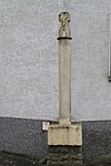
| Friedhofstrasse 2 (at) Lage |
Plague cross | Simple plague cross on an embossed base. Above it, a round column with the year 1616 . A bead closes the column. A wide crucifix with a gilt figure of Christ at the top. |
|
| Friedhofstrasse 19 (at) Lage |
Plague cross | The plague cross from 1688 is supported by a cube-shaped base. Above it stands a rectangular column, tapering towards the top, on the front of which a putti has a cartouche with a tassel hanging around its neck, on which the year of construction and the first letters MD of the founder are written. The cross is completed by a crucifix with a cast iron figure of Christ. |

|
| Kirchstrasse 5 location |
Courtyard house of the St. Maximin Abbey in Trier, monastery property, mill | The building was built in the 18th and 19th centuries. Century as the courtyard house of the Imperial Abbey of St. Maximin directly on the Moselle. | |
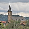
| Kirchstrasse 7 location |
cath. St. Margaretha Church | The church was built in 1848/49 according to plans by the architect Alexius Faure under the direction of the Trier master builder Josef Weis. The hall building with high windows is completed by a retracted choir with a five-sided end. The flat ceiling ends with a wide hollow. The narrow church tower was easily pushed into one gable end. There is a round arch portal on both sides of the tower. In the tower itself, a similar portal is set as a niche in which a crucifix stands. |
|
| Schulstrasse 1 location |
Plague cross | Simple wayside cross from 1616 with a gilded figure of Christ on the crucifix in the top. On the shaft a cartridge with the name of the donor and the year. |

|
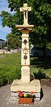
| Tettinger Strasse location |
Norman cross | Lorenz Surwin von Besch had the Norman cross set up in 1688, as explained by an inscription in the lower part of the shaft. This shaft is supported by an embossed base, which is closed at the top by a cantilever canteen. On it a crucifix with Christ. On the tapering part of the shaft, putti with a cartridge around the neck, with the year 1688 and the letters LSW. A cone and a tassel also hang from the cord. |
|
Borg
| location | designation | description | image |
|---|---|---|---|
| Johannesstrasse 21 location |
cath. Church of St. John | The church was built in 1921/22 according to designs by Josef Monz from Trier. Shortly after the beginning of the Second World War, the church tower was blown up, and the nave was also destroyed. Between 1948 and 1951 the church was rebuilt according to the original plans. The gable portal with closed vestibule and portico above it is striking . The basilica is dominated by a strongly vaulted barrel vault. A baroque high altar stands in the semicircular choir. There are two baroque side altars on the choir wall. |

|
Büschdorf
| location | designation | description | image |
|---|---|---|---|
| Im Brühl 3 location |
cath. Chapel of St. Michael | St. Michael was built in 1867 by the civil parish as a hall with a semicircular choir with neo-Romanesque and neo-Gothic style elements. Arched friezes decorate the building, buttresses also structure it. In the south side of the gable sits a simple round arched portal made of red sandstone with a rose window. Above that is a gable made of yellow sandstone in the gable roof. |
Eft-Hellendorf
| location | designation | description | image |
|---|---|---|---|
| Efter street location |
cath. Chapel of St. Maternus | The chapel was built in 1855 and rebuilt in 1905. The small hall building with a gable roof was built over a narrow sandstone base and is plastered. A large courtyard building was added on the north side at the beginning of the 20th century. So only three arched windows of the original six have been preserved on the southern long side. The entrance portal with the ocular above is on the gable side in the east. On the gable is an open gable made of red sandstone with a bell. | |
| Kirchenstrasse 13 location |
cath. Church of St. Philip and Jacob with furnishings by André Streng | The first church was built in 1569, but only the tower remains. The nave dates from 1724/25, in 1908 it was extended by an axis in romanized forms by the architect André Streng. The church has two baroque altars. |

|
| Merziger Straße |
Wayside shrine | 18th century |
Keßlingen
| location | designation | description | image |
|---|---|---|---|
| Kapellenstrasse 8 location |
cath. Filial church St. Jakobus with equipment | The original church is believed to be from the 14th or 15th century. Only the choir remains of her. In 1796 this was expanded to include a sacristy. In addition, the ship and a tower on the west side were rebuilt. In the 19th century the church received a neo-Gothic portal. St. James was destroyed in World War II and rebuilt in the 1950s. St. Jakobus is a simple, flat-roofed, rectangular hall with two window axes. A square tower with a baroque dome and a round arched portal was placed in front of the nave. |

|
| Kapellenweg |
Wayside cross | 1736 |
Münzingen
| location | designation | description | image |
|---|---|---|---|
| Gliederbachstrasse location |
Wayside cross | 18th century |
Nennig
| location | designation | description | image |
|---|---|---|---|
| Bübinger Strasse location |
Water tower and pump house | 4th quarter of the 19th century |

|
| Bübinger Strasse location |
Signal box Nennig | 4th quarter of the 19th century |

|
| Kirchplatz 1 |
catholic rectory | 1754 | |
| Kirchplatz 2 location |
cath. St. Martin Church | From the first church in Nennig only the Romanesque west tower remained. In 1740 a new nave was built, but it was torn down again in 1790. Between 1803 and 1805 a new nave was built and the tower was raised by a fourth storey. In the 1870s the tower was raised again. The hall building with a three-sided choir closure is clearly characterized by classicism. |

|
| Roman road location |
Mount of Olives Chapel | The first Ölberg chapel was built in 1787, and today's chapel was built in 1868. The furnishings include a Rochus statue in a niche above the arched entrance in the top of the gable, as well as a relief on a massive base on the front wall, which shows the fearful scene on the Mount of Olives. |

|
| Römerstrasse 11 location |
Roman villa Nennig | Only the foundations of the former Villa urbana have been preserved. The most important find of the portico villa is the almost completely preserved floor of the reception hall. The approximately 160 m² mosaic was arranged around a water basin and consists of six octagons and one rectangle, which depict scenes from the Roman battle arena. The protective structure dates from around 1874. |

|
| Schlossstrasse |
Farmhouse with barn | 18th century | |
| Schlossstrasse location |
Berg Castle , Upper Castle and Lower Castle | The origins of the Renaissance castle go back to the 9th / 10th centuries. Century back. In 1580 the moated castle was expanded into a palace. In the war winter of 1944/45, the castle was almost completely destroyed. The Saarland became owners in 1950, had the castle rebuilt from 1955 and used it as a school camp until the 1980s. In 1986 Saarland Sporttoto GmbH acquired the castle and had it converted into a hotel under the architects Bernhard Focht and Erich Fisabre and the interior designer Siegward Graf Pilati. |

|
| Sinzer Strasse location |
Bübingen castle ruins | Bübingen Castle was originally a moated castle from around 1340. It was destroyed in 1635 and 1668 and rebuilt at the beginning of the 18th century. In the late 18th century, the von Maringh family bought the ruins and rebuilt the castle. At the end of the Second World War, the castle was destroyed again and has been in ruins ever since. Of the former three-storey structure with two side projections and two round towers on the other long side, only the foundation walls have been preserved. The plastered building had three to nine axes and was covered with a hipped roof. |

|
| Weinbergstraße |
Wayside cross | 1744 | |
| Wieser Straße |
Wayside cross | 18th century | |
| Wieser Strasse 15 location |
cath. Chapel of St. Sebastian | The chapel, built in 1877, has three window axes with round arches. A high arched portal sits on the gable side. A square slate roof turret sits enthroned above it. In a round arch niche above the portal stands a figure of St. Sebastian. The furnishings include a baroque altar. |
Pearl
| location | designation | description | image |
|---|---|---|---|
| Bahnhofstrasse location |
Ensemble railway settlement | During the First World War, the Moselle route from Koblenz to Metz was interrupted by the new German-French border. After 1918, larger train stations for customs clearance were built on both sides. The Perl station building, designed by the architect Vossbeck from Trier, was rebuilt from 1926 onwards. The new station required significantly more staff than before. The required living space was created with the railway settlement. In 1926/27, the architect Voßbeck created nine axially symmetrical two-storey semi-detached houses with slate-hip roofs and dormers. House number 45/63 stands above the cul-de-sac and, as a gatehouse to the settlement, forms the entrance to the other residential buildings. | |
| Double house at Bahnhofstrasse 37/39 | |||
| Double house at Bahnhofstrasse 41/43 | |||
| Double house at Bahnhofstrasse 45/63 | |||
| Double residential building at Bahnhofstrasse 47/49 | |||
| Double house Bahnhofstrasse 51/53 | |||
| Double house at Bahnhofstrasse 55/57 | |||
| Double house at Bahnhofstrasse 59/61 | |||
| Double house at Bahnhofstrasse 65/67 | |||
| Double house at Bahnhofstrasse 69/71 | |||
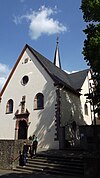
| Biringerstraße 1 location |
cath. Church of St. Gervasius and Protasius | From the original church, a Romanesque tower with a late Gothic choir on the south side has been preserved to this day. In 1716 a new nave was built. In 1928, the church was extensively expanded according to plans by the Trier architect Julius Wirtz and a new main nave with barrel vault was added to the old nave to the north. The old nave became a transept and the apse became a side chapel. The new choir was designed as a rectangular choir with space for a baroque high altar. To the left and right of this there is a round window and an arched window above. The square tower is covered by a pointed and high dome. |
|
| Biringerstraße 9 location |
cath. Chapel of St. Quirinus | The current source was built in 1712 and soon became a destination for pilgrims. In the course of secularization after the French Revolution, the chapel belonged to the von Nell family from 1803, who donated the church to the Catholic parish of Perl in 1936. The chapel has been a war memorial site since 1950. The small hall has a choir with a three-sided end from which a breakthrough leads into the oldest part of the chapel from the 17th century. The two sides of the eaves are pierced by two window axes each and are supported by buttresses. A roof turret with a high hood sits on the slated gable roof above the choir. The entrance is on the north gable side in a round arched portal with an inscription. Above it is a coat of arms with the year 1712. |

|
| Biringerstraße 12 location |
Palais von Nell , courtyard house with press house and equipment | The baroque castle was built in 1733 and a wine press house was added at the end of the 18th century. During this time, the Trier merchant and banker Georg Friedrich Job von Nell acquired the building. It remained in the family's possession until 1982. After 1945 it was a restaurant for a few years and then from 1961 to 1980 it was an educational and leisure center of the Saarland youth welfare organization. It has been privately owned since 1982. The originally nine-axis building with two storeys and corner blocks is completed by a high mansard roof. In the north, the old wine press house connects with a large arched gate. |

|
| Katzenberg location |
Cat house | The cat house is a pleasure house built around 1850 by Christoph Bernhard von Nell on a vineyard. The tower-like building with two floors is covered by a pyramid roof. You enter the building via an opposite staircase on the upper floor. While the upper floor has tall rectangular windows, the lower floor only has small square windows. |

|
| Quiriniusstraße 1 |
Residential building | 1817 | |
| Wiesenweg 1 |
Old abbey, residential building | 1733 | |
Sehndorf
| location | designation | description | image |
|---|---|---|---|
| Niederborn |
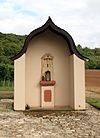
Plague cross | The plague cross was created in 1666. On a high plinth is a small cafeteria on which a wayside shrine with scenes of the crucifixion and the year of construction is depicted. The cross is protected by a small, open chapel with a roof shaped as a keel arch. |
|
| Marienstraße 27 location |
cath. St. Mary's Chapel | The Marienkapelle was built in 1843 by the entrepreneur Johann Peter Mersch and his wife Anna and given to the Catholic parish. Access to the white-painted plastered building with a gable roof is via a portal with a round arch. The long sides each have three window axes with round arches. |

|
Sinz
| location | designation | description | image |
|---|---|---|---|
| Hauptstrasse 13 location |
cath. St. Dionysius Church | The first Dionysius Church was built in 1653. The current church was built in 1844, but was destroyed in the Second World War. In 1950 the architect H. Ulrich from Perl rebuilt and converted it. the hall, built in neo-Romanesque forms, has a square tower on the choir side. On the opposite side of the gable is the arched portal with oculus. The long sides have eight window axes, of which the four outer ones were designed as small arched windows, the middle ones as larger ones. |

|
Tettingen-Butzdorf
| location | designation | description | image |
|---|---|---|---|
| Zerwasstrasse 4 location |
cath. Church of St. Remigius with furnishings | The single-nave neo-Romanesque plastered building was built in 1851 by Josef Weis from Trier. A square tower with the main portal was pushed into one of the stepped gable ends. In each of the long sides there are four axles with arched windows. |

|
Weekers
| location | designation | description | image |
|---|---|---|---|
| Outside of the location |
Plague cross | 1666 | |
| Donatusring 8 layer |
Dundeshof with farm building | The Dundeshof in the center of the village originally belonged to the Rettel Monastery and was built with the farm building in 1767. Today's facade has six axes, three of which are designed as doors on the ground floor. The entrance to the business section is now a simple, upright rectangular door. The middle door is located in a slightly profiled segment arch portal. Another portal is in the baroque style. It has a blown gable with a niche with a statue. A coat of arms with the Lorraine double cross indicates that the monastery was the builder. |

|
| Nikolausstrasse location |
Wayside cross | The wayside cross, made of sandstone in 1812, stands on a base converted into a cafeteria. The multi-part shaft consists of a small base, a cube with an inscription, above a curved stone with the heart of Jesus and on top of it the actual crucifix with body. |

|
| Nikolausstrasse 7 location |
Farmhouse | 1851 |

|
| Nikolausstrasse 9 location |
Farmhouse | 1842 | |
| Nikolausstrasse 14 location |
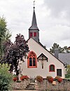
catholic chapel of St. Bernhard and St. Nicholas | The origins of the St. Nicholas and St. Bernard Chapel go back to the 15th century. The choir comes from this time. In 1789 the current nave and sacristy were built and the choir arch was then broken through. Another renovation took place in 1816 and the church got its roof turret. The small hall with a rectangular choir is covered by a steep and deep roof with a turret. In the east wall of the choir there is a two-part Gothic tracery window. The ribbed vault is supported by narrow services without capitals. |
|
| Nikolausstrasse 13 location |
Farmhouse | 19th century |

|
| Nikolausstrasse 23 location |
Farmhouse |

|
Web links
Commons : Architectural Monuments in Perl - Collection of images, videos and audio files