List of cultural monuments in Großolbersdorf
The list of cultural monuments in Großolbersdorf contains the cultural monuments in Großolbersdorf .
This list is a partial list of the list of cultural monuments in Saxony .
Legend
- Image: shows a picture of the cultural monument and, if applicable, a link to further photos of the cultural monument in the Wikimedia Commons media archive
- Designation: Name, designation or the type of cultural monument
-
Location: If available, street name and house number of the cultural monument; The list is basically sorted according to this address. The map link leads to various map displays and gives the coordinates of the cultural monument.
- Map view to set coordinates. In this map view, cultural monuments are shown without coordinates with a red marker and can be placed on the map. Cultural monuments without a picture are marked with a blue marker, cultural monuments with a picture are marked with a green marker.
- Dating: indicates the year of completion or the date of the first mention or the period of construction
- Description: structural and historical details of the cultural monument, preferably the monument properties
-
ID: is awarded by the State Office for the Preservation of Monuments in Saxony. It clearly identifies the cultural monument. The link leads to a PDF document from the State Office for the Preservation of Monuments in Saxony, which summarizes the information on the monument, contains a map sketch and often a detailed description. For former cultural monuments sometimes no ID is given, if one is given, this is the former ID. The corresponding link leads to an empty document at the state office. The following icon can also be found in the ID column
 ; this leads to information on this cultural monument at Wikidata .
Grossolbersdorf
| image | designation | location | Dating | description | ID |
|---|---|---|---|---|---|
 |
Großolbersdorf town hall | Am Rathaus 8 (map) |
1924 | Municipal office building, representative plastered building, still in the reform and Heimat style of the time around 1910, of architectural and local significance
Good original inventory, with a semicircular central balcony on pillars. |
09236695
|
 |
Gasthaus "Zur Linde" | At the church 2 (map) |
re. 1819 | with half-timbered upper floor, once a bakery and distillery, of local and architectural importance
Half-timbered upper floor, half-hipped roof, corresponding roof structures, massive ground floor, eaves-side extension, roof house on the east gable, bakery and distillery since 1799 - owner at that time hereditary lease miller Carl Gotthard Lohwinkler from Scharfenstein |
09236697
|
 More pictures |
Church (with furnishings) , churchyard with churchyard wall, tombstone Fam. Mey and war memorial for those who fell in the First World War | At the church 4 (map) |
around 1400, later expanded | Basically a Gothic hall church with a polygonal choir, over-molded in baroque style, a striking roof turret as a church tower, of local and architectural significance
Erected as a chapel around 1400, current chancel from this construction phase, the rest of the church was destroyed by Sweden under General Königsmark in 1643, gradually renovated without any decoration, in 1707 the church was expanded by half, in 1834 a tower, star vaults in the choir, single-nave church, closed on three sides, built-in galleries on the long side, Altar: crucifixion group with flanked central relief, donor figures v. Einsiedel, hipped roof with attached tower, gravestone in the churchyard: badly weathered |
09236698
|
| Former church school | At the church 6 (map) |
in the core 1579 | Upper floor half-timbered, school until 1889, later bakery and residential building, of local and architectural importance
Expanded in 1844, classicist porphyry tufa door frame from this time, former boys' school, from 1889 bakery, external building structure from 1844, original door and window walls, solid gable and one eaves side, crooked hip roof. The building was probably expanded in 1844 (eastern gable side). The roof structure (double standing, partly later supplemented with central supports) and the strong foundation walls point to the core of the house from the 16th century. |
09236699
|
|
| Former factory owner's villa, gate entrance and villa garden (garden monument) | Grünauer Strasse 14 (map) |
1905 | representative plastered facade with ornamental framework, corner tower, good original condition, in the neo-renaissance style with Art Nouveau decoration, gate entrance with two gate pillars and ornamental grille, garden with path system, water basin and space-creating planting, built for the Heymann family of manufacturers, significance in terms of local history, architectural history and garden art
Villa: good original condition inside and outside, lead glass windows, front door and windows, banisters, bars, plastered facade with ornamental framework, concrete window frames with ornamental decoration, garden: see garden monument conservation inventory: south of the villa in front of the villa, well preserved, curved path system, tuff-edged water basin with fountain and a small waterfall running over three steps made of tuff stone, structure and space-forming woody stock (rhododendron, lilac, chestnut, maple, linden as well as Douglas fir and white pine) |
09236701
|
|
| Residential stable house, barn and side building of a farm | Grünauer Strasse 32 (map) |
1769 | Stable house on the upper floor high-end timber-framing, boarded barn, of architectural significance
Half-timbered upper floor, massive ground floor, gable roof, both gables covered with wood |
09236703
|
|
| Mine tunnel and mouth hole | Grünauer Strasse 59 (near) (map) |
1558-1636 | of importance in terms of local history and mining history |
09236679
|
|
| Residential house of a mill estate | Grünauer Strasse 71 (map) |
around 1800 | Upper floor half-timbered, partly plastered, former grinding mill, of local history
Half-timbered upper floor, massive ground floor, oven, a massive gable, hipped roof, original door walls and original front door, sliding windows |
09236704
|
|
| Residential house, with enclosure | Grünauer Strasse 73 (map) |
around 1900 | Historic plastered building, with floating gables, historically important.
Floating gables, window frames, plastered facade with pilaster strips, plaster ashlar on the ground floor, original front door, windows are currently being replaced, wooden vestibules with window glass etchings |
09236705
|
|
| Residential building, former school | Hauptstrasse 9 (map) |
marked 1825 | Upper floor half-timbered, former girls' school from 1825–1888, of local historical importance.
1825–1888 school, then residential building, massive gable, half-timbered upper floor, original door and window frames, dated on the window frames, beautiful front door |
09236706
|
|
| Residential building | Hauptstrasse 38 (map) |
around 1830 | Upper floor half-timbered, of architectural significance.
With original window and door walls, half-timbered upper floor, both gables partly solid, gable triangles half-timbered, gable roof |
09236707
|
|
| Residential building | Hauptstrasse 130 (map) |
around 1800 | Upper floor half-timbered, partly slated, of architectural significance.
Half-timbered upper floor, solid ground floor, windows on the street side clogged, original door walls, gable roof |
09236708
|
|
| Residential building | Hauptstrasse 151 (map) |
in the core probably 1756 | Upper floor half-timbered, partly slated, of architectural significance.
Half-timbered upper floor, massive ground floor, gable roof, original door frames |
09236709
|
|
 |
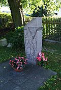
Gravesite of Karl Stülpner and OdF memorial stone in the cemetery | Heinzebankstrasse 2 (map) |
after 1841 (Karl Stülpner's grave) | Historically significant.
Karl Stülpner : died 1841, OdF memorial stone for two concentration camp prisoners murdered by the SS in 1945, cemetery chapel inaugurated in 1906 |
09236700
|
| Residential building | Scharfensteiner Strasse 9 (map) |
1902 | Wilhelminian style clinker building, belonged to the former Heymann stocking factory, of architectural and local significance.
Yellow clinker brick, original front door and windows, rich interior fittings including stairwell lighting, apartment doors, lead glass windows with Art Nouveau ornamentation, belonged to the former Heilmann stocking factory |
09236710
|
|
 |
House, now a museum | Schulstrasse 16 (map) |
inscribed 1839, later reshaped | Upper floor partly in half-timbered, former craftsman's house (Sättler Karl-Haus), today village museum, of local history.
Dated ground floor, half-timbered upper floor probably from the second half of the 18th century, both solid gables |
09236711
|
| Guild drawer in the museum | Schulstrasse 16 (near) (map) |
1851 founding year of the guild | Historically significant.
Elm wood drawer, lathed, two handles for carrying, lid decorated with inlays, three keys, lock has brass fittings, drawers were used to store papers and money, today bills and statutes of the former funeral society "United Craftsmen" |
09235773
|
|
| Residential building | Seilergasse 1 (map) |
marked 1903 | With built-in shop, Gründerzeit plastered facade with volute gable, in the style of historicism, of architectural significance.
Plastered facade with corner cuboid, drawer from the time of origin, windows partly original, decorative gable, volute-like with shell ornament |
09236712
|
|
| Schnitzberg with scenes from the life of Karl Stülpner | Warmbadstraße 19 (near) (map) |
1936-1938 | Set up in the Schnitzerheim since 1957/58, of importance in terms of craftsmanship and local history.
100 carved figures of the carving and crib association, idea and some figures by Kurt Seidel. Landscape around Scharfenstein and historical buildings (no longer preserved today), high-quality carved figures, solid craftsmanship in traditional forms, 13 m² area, local historical value based on the documentation of the life of Karl Stülpner |
09236680 |
Grünau
| image | designation | location | Dating | description | ID |
|---|---|---|---|---|---|
| Manor house of a Vorwerk | Am Hof 2 (map) |
18th century, probably older in the core (manor house) | Plastered building with mansard roof, part of the former Grünauer Hof, Vorwerk of Scharfenstein Castle, architectural value and local historical importance
Six-axis solid construction, two-storey, expanded mansard roof, small skylights |
09207050 |
Hohndorf
| image | designation | location | Dating | description | ID |
|---|---|---|---|---|---|
 |
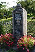
War memorial for the fallen soldiers of the First World War | Dorfstrasse 22 (near) (map) |
1922 | Local historical significance.
Small grove of honor with artificial stone monolith and black marble plaque, in the base an iron cross in an oak wreath, top end crowned with a steel helmet |
09207055
|
 |
Mill building with attached side building | Mühlweg 4 (map) |
Mentioned in 1812, probably older | Picturesque mill in the Tischau valley, upper floor half-timbered, construction typical of the time and landscape, significance of local history.
Multi-section building, main building two-storey, massive, only the gable side still original with Prussian half-timbering, porphyry walls, boarded up in the roof area, auxiliary building: solid ground floor, upper floor half-timbered, boarded up |
09207054
|
| milestone | New Main Street - (map) |
marked 1831 (milestone) | At the crossroads to Krumhermersdorf, regional and traffic historical importance.
Porphyry column on a rectangular base, inscribed "Hohendorfer Flur 1831", on the side Kurschwerter, the column inscribed "Zschopau, Chemnitz, Leipzig, Marienberg, Reitzenhain, Prague, Schellenberg, Oederan, Frankenberg" |
09207058
|
|
 More pictures |
Former school | Way to school 4 (map) |
1897–1898, later expanded | Wilhelminian style building with tower, significance for the local history and the townscape.
A stately, two-storey solid construction with 9: 2 axes, single-axis central projection, above the ground floor cornice, profile strips under eaves as the end of curved gable with clock and bell tower with weather vane |
09207056 |
Hopfgarten
| image | designation | location | Dating | description | ID |
|---|---|---|---|---|---|
| War memorial for those who fell in World War I | At the sports field - (map) |
after 1918 | Local historical significance.
High quarry stone stele with an iron cross and two bronze plaques, today for those who died in the First and Second World Wars |
09207051
|
|
| Residential stable house and barn of a two-sided courtyard, with a connecting passage between the two buildings over the field path | Hauptstrasse 3 (map) |
18th century, later reshaped | Buildings typical of the time and the landscape, in a location that shapes the townscape, of architectural significance.
Two-storey stable house, ground floor quarry stone, upper floor after 1892 in brick, gable roof, barn: high quarry stone base, wooden construction |
09207047
|
|
| Inn with hall extension | Hauptstrasse 9 (map) |
1900 | Stately building, in the late historical style, characterizing the local image and the local history.
Stately, two-storey solid construction with 5: 3 axes, arched portal and windows, stone walls, on the upper floor with curved ends, dormer windows with adjoining dormer windows, two-story hall extension, ground floor garages, upper floor four large round-arched hall windows with stone walls, hipped roof |
09207046
|
|
| Former factory owner's villa and villa garden (garden monument) | Hauptstrasse 16 (map) |
around 1920 | Plastered building, in reform and Heimat style, part of the Wendler wood pulp and cardboard factory, architectural value and local historical significance.
Stately, multi-section building over a high polygon base, single-storey solid construction with a loft, rich roof landscape, original front door and partly original windows, recorded (1999) as part of the former Zickner wood grinding factory, probably referring to the Wendler factory |
09207044
|
|
| Road bridge over the Zschopau | Heidelbach - (map) |
Mid 19th century | Stone arch bridge, importance for traffic history (see also the municipality of Wolkenstein, Heidelbachstraße - Obj. 09207708).
Single arched round arch bridge, the bridge is part of the old Drebach – Wolkenstein road, the current Heidelbachstraße. The corridor boundary is in the middle of the river. As a result, the eastern half of the bridge (district of Wolkenstein, Heidelbachstrasse) belongs to the city of Wolkenstein and the western half of the bridge (district of Hopfgarten, Heidelbach) belongs to the community of Großolbersdorf. |
09305379
|
|
| Kalkwerk Heidelbach , totality of the Royal Kalkwerk Heidelbach | Heidelbach 57 (map) |
around 1500 and later | Remains of the complex of regional and industrial historical importance. Material entity, consisting of the individual monument: civil servants 'residence (see individual monument list - Obj. 09207052, Heidelbach 57) furthermore consisting of the material entirety parts: mouth hole of the driveway, barn, workers' house, powder tower, wall remains of the conveyor shaft, fume cupboard and terraced area with retaining walls and stairs |
09207053
|
|
| Residential building | Heidelbach 57 (map) |
around 1850 | Individual monument of the totality of the Königliches Kalkwerk Heidelbach: Former civil servants' residence (see also the list of objects as a whole - Object 09207053, Heidelbach 57), building typical of the time and landscape, of local importance. Heidelberg
Two-storey, massive house, ground floor former stable with garage extension, porphyry walls, twin windows in the gable, protruding gable roof on decorative wooden consoles, dormer windows |
09207052
|
|
 |
Former school | Uferstrasse 4 (map) |
re. 1889 | Typical plastered building with tower, significance for the local history and the local image.
Stately, two-storey solid construction of 7: 2 axes, single-axis central projection, slightly protruding, flat arch portal, keystone marked (1889), at the end a curved gable with clock and bell tower, saddle roof |
09207045 |
Remarks
- ↑ The list may not correspond to the current status of the official list of monuments. This can be viewed by the responsible authorities. Therefore, the presence or absence of a structure or ensemble on this list does not guarantee that it is or is not a registered monument at the present time. The State Office for the Preservation of Monuments in Saxony provides binding information .

